Tag Archives: Geology

Eolian Deposition

Loess Caves in China

While studying a geography unit in grade school I was fascinated by the extensive deposits of loess in China.  Loess is fine wind-deposited soil.  In China, the loess covers a huge area in central China and is an important agricultural region.  The soil is fertile, easy to work, and when it erodes it can form steep cliffs.  People have carved homes into the cliffs for centuries, long enough to be included in geography books in western Colorado.  I lived in western Colorado cliff country, probably responsible for my interest in loess.

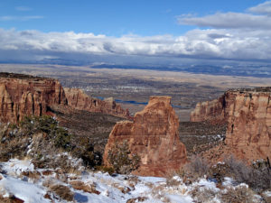
Loess is eolian soil, meaning it is wind deposited.  There is also wind deposited sand.  The Colorado National Monument, across the Colorado River from Fruita where I grew up has lots of eolian sandstone.  The cliff forming Wingate and the arch forming Entrada Sandstone are ancient sand dunes turned to stone.  My fascination for wind deposited cliffs comes naturally.

I now live east of the Rocky Mountains.  The mountains are tall and rugged, but are in the process of wearing away.  The Rockies have had several glacial periods.  Glaciers form, grind the mountains, then melt and leave their grinding as sand, silt, and gravel called glacial till. The more coarse debris often was carried in huge quantities onto the plains.  The  smaller particles, sand and silt, were blown onto the plains east of the eroding mountains.

The sand has created extensive sand hills on much of the plains in Colorado.  The sandy soil is thin and fragile, poor for farming, but fine for livestock grazing.  Interspersed among the sand hills are loess deposits now farmed extensively with water drawn from the Ogallala Aquifer in the Ogallala Sandstone, which was washed out of the mountains as the glaciers melted. The Ogallala extends from the mountains into Nebraska and south into the Texas Panhandle.
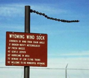
You may be aware the wind blows in Wyoming.  The entire atmosphere passes through Wyoming in any 24 hour period.  You have seen the Wyoming Wind Gauge?  It’s a logging chain hanging from a post.  I may exaggerate here, but not much.

While blowing, wind carries sand eastward out of the mountains. It also erodes the prairies in eastern Wyoming.  The sand ends up in the Western Nebraska Sand Hill country, covering over a quarter of the state.  The silt blew farther east, building loess deposits along the rivers.

In the dust bowl years in southeastern Colorado, northeastern New Mexico, southern Kansas, and the Texas and Oklahoma panhandles, the dust storms sent silt as far as Washington D.C.  Wind blown stuff is a big deal everywhere.  In North Africa, the sandy deserts are getting sandier as the silt is picked up and blows across the Atlantic Ocean, fertilizing the Amazon Basin.

In Denver, a car sitting outside for several days acquires a significant coat of wind blown dirt.  A couple of years ago, the dirt was red, meaning it originated in eastern Utah.   I notice my sidewalk is lower than the lawn by a couple of inches.  How much of it is organic accumulation and how much is eolian silt and sand?

I went for a long time thinking water is responsible for most of erosion.  It may be true, but don’t discount the wind, especially in Wyoming.
The Urban Oil Field

Oil and Gas Wells in Part of Weld County

Weld County, Colorado is one of the richest agricultural counties in the nation.  It is also rich in oil and gas, leading to hundreds of wells extracting petroleum.  With all that money around, Northern Colorado is booming, with people moving and subdivisions being built on what was farmland.  The houses and wells are often neighbors, close neighbors.  As oil companies put profit ahead of proper well management, disasters ensue.  Colorado has lots of fires in the urban-wild land interface.  In Weld County it is the urban-oil field interface.

Colorado is home to 48,000 active wells and 52,000 abandoned wells.  All of them are potential  fire and explosion hazards, and can release methane into the atmosphere.  Think about that when your furnace comes on in the morning before you head out to your car.  We need renewal energy.

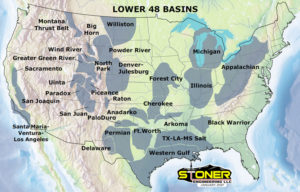
The Denver Basin is a huge geologic feature extending along the eastern front of the Rocky Mountains.  As the Rockies were uplifted, the Denver Basin subsided while filling with debris washing out of the mountains.  There is a 22,000 feet difference between the bottom of the Basin and the summits of the mountains.  That is a lot of gravel.

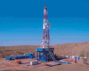
When there is a lot of structure in geologic formations, there is opportunity for oil and gas to migrate into the rocks.  The Denver Basin is one of the largest gas fields in the United States.  Oil and gas extraction started in 1901 in Boulder County.   Trillions of cubic feet of gas and millions of gallons of oil have come out of the ground since then.  Most of the production has come from sandstone or fractured shale.  The development of horizontal drilling and fracking has accelerated the process.  In Weld County, sites with as many as five wellheads and the installations to process the gas are next to residential areas.

Oil Fire Near Homes

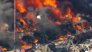
The result is spectacular explosions and fires near where people live.  Local fire departments, once used to fighting grass and barn fires, have sprayed thousands of gallons of firefighting foam on the fires and spent days on the fire scenes.  Attempts to increase regulation of the industry mostly fail due to the political clout of the oil and gas industry.  The politics may change with the election of Democrats to most of the state offices.

Keep in mind the oil bonanza is a major source of Colorado’s economy and growth.  The move to renewables is also a source of revenue to the region, but there will be inevitable disruption during the transition.  The oil and gas industry seems to be focused on keeping the wells flowing, regardless of the environmental consequences.  They do not seem to be shifting into renewals themselves, which may be a death knell.  Market forces will probably prove to accelerate the shift to renewables.  They are much cheaper than dragging fossil fuels out of the ground and pouring tremendous amounts of carbon into the atmosphere.  The remains of dinosaurs and ancient swamps need to stay in the ground.

Kilauea

Kilauea

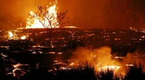
We are living in a momentous time.  The island of Hawai’i is growing.  The entire island is volcanic.  The northern portion of the island is dormant, the south is more active.  It is called the big island, appropriate as it is still growing.  The current eruption started sending lava into the ocean on May 22 and continues as of this writing, August 3.

It seems volcanos are popular places to settle.  Worldwide, people are killed or forced to leave as the earth starts emitting hot stuff near their homes.  Kilauea has forced more than 2000 evacuations.  When Mt. Pinatubo in the Philippines erupted in 1991, more than 60,000 people had to leave.  Fortunately, they had some warning which saved many lives.

It is a mystery to me why development was allowed on Kilauea where lava covered the land as recently as 1960.  Yes, people have property rights, but government has the power to zone property.  It rains a lot in Hawaii, and volcanic soil is fertile, so evidence of lava flow is quickly obscured.

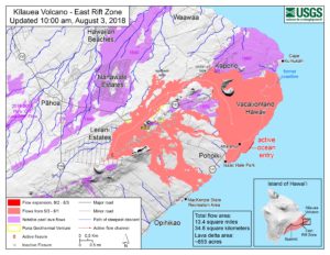
I enjoy looking at the daily USGS reports and maps.  The flows go where they will, without any discernible pattern.  For a week a boat ramp becomes more vulnerable to the encroaching lava, then more lava decides to enter the ocean nearby.  It also seems strange the lava travels so far from the rift before spreading.  The channel from the rift is well established and the levees on either side are growing. The channel is rising and I expect breakouts much closer to the rift, but nothing seems to happen.  I just looked at yesterday’s map.  Lava has broken out upstream from the ocean entry.  I feel vindicated.

Asks usual, government agencies insist on limiting access to the lava flows.  Yes, I understand many people will put themselves in harm’s way and need rescue, but here in Colorado people regularly kill themselves in the mountains and access is allowed.  I would love to put on my heavy boots and look down on a lava stream.   As it is, I read online accounts of people sneaking into closed areas to look at a volcano at work.


Caldera Eruption

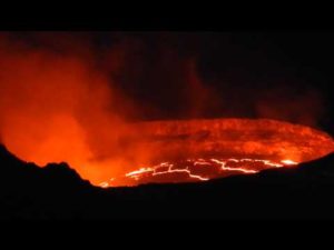
The crater is another phenomenon worth seeing.  Before this eruption the lava lake in the crater fluctuated in elevation due to varying supply from the magma reservoir below.  Once the fissures opened some distance from the caldera the lava lake began dropping.  The amount of lava now flowing down the channel exceeds the supply that was in the crater.  Thus, magma is flowing up from the deep.  The Hawaiian Hotspot is alive and well and the archipelago continues to grow.  Pele is not at all concerned about people scurrying around on her rocks.

El Volcan De Fuego

Fuego

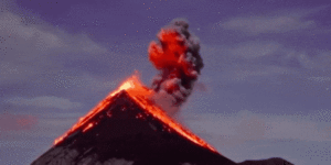
I no more than post about Kileaua, a shield volcano, when Fuego, a stratovolcano, lets loose.  Guatemala is part of a string of beautiful Central American countries harboring many volcanos.


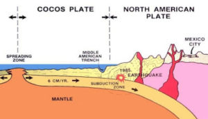
The Cocos tectonic plate is smashing into the North American Plate just north of the Caribbean Plate.  As the Cocos dives below the North American, its rock containing lots of water goes down (subducts) and is heated by the hot magma in the mantle.


Pyroclastic Flow

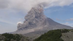
New, lighter magma is formed which then rises and erupts.  The volcano’s lava doesn’t just flow out as in Hawaii.  Stratovolcano magma is more viscous, sticks and plugs the magma channel until pressure builds up and it blows in an explosive, destructive eruption.  The hot stuff rises into the atmosphere (ash), and also flows down the mountain as a  pyroclastic flow of superheated rock and ash, the killer.  Pinatubo in the Philippines, Pompeii, Etna, Mt. St.Helens,

Rainier, Lassen, Hood, and El Volcan de Fuego (Fuego=Fire).  The volcanos ring most continents and island arcs.

Kileaua has been erupting for a month with just a few injuries, and Fuego has probably killed hundreds in one day.  Don’t live too close to a stratovolcano.

Draining the Colorado Plateau

Grand Canyon

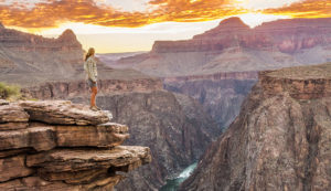
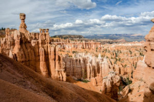
About 600 Million years old, the Colorado Plateau has been relatively stable throughout it’s history.  It has uplifts, interesting laccolithic mountains, lava flows, and In the last six million years or so, produced some of the most spectacular scenery on the earth.  Canyons.  Many canyons carved into many layers of rock, much of it red.  The canyons grew upstream from the Grand Canyon, the most spectacular of the canyons.

Some of the Colorado Plateau, Bryce Canyon

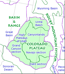
The Plateau is big, about 130,000 square miles.  It could swallow some of those little Eastern states with hardly a belch.  Utah east of the Wasatch mountains just east of Salt Lake.  Colorado west of the Rocky Mountains, south of the Uintah mountains and north of that rough country in northern New Mexico and Arizona.

For much of its history the Colorado Plateau was drained interiorly, no outlet to the oceans and surrounded by highlands.  The rivers then flowed north from now gone highlands in Arizona into a succession of mostly fresh water lakes.  The lakes left signatures such as the Green River Formation with its oil shale and landslides.  The Piceance and Uinta basins are examples. I grew up on a margin of the Piceance Basin.

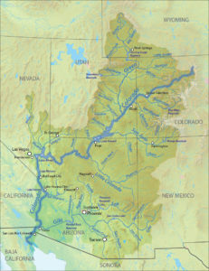
Colorado River

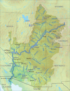
Around six million years ago, the Colorado River flowed south, found its way onto the Basin and Range Province and eventually to the Gulf of California.  It is ironic such a powerful river responsible for carving all those canyons seldom reaches the sea, diverted onto land by recent despoilers, us.  The shift from internal drainage to the Colorado River with all the canyons carved by the river and tributaries is something of a mystery.

The answer is elevation change.  The Colorado Plateau ended up higher than the Basin and Range province to the west.  Was the Plateau uplifted or did the Basin and Range subside?  The change in elevation is relatively recent and gave the Colorado River the opportunity to begin draining the Plateau.

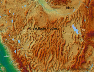
The Basin and Range With Stretch Marks

The Basin and Range is known as an extensional region.  As the Pacific Tectonic Plate slides northward along the North American Plate, it is stretching and pulling the Basin and Range to the west.  As it pulls apart, some big blocks stay at about the same altitude while adjacent blocks drop down to fill the void.  Thus we have basins and ranges.  There are theories that the entire province subsided as well.

This is probably not the case, as the crust under the region is thinner, a function of stretching, not uplift.  With uplift, we would expect the crust to be thicker.  The crust is thicker under the Colorado Plateau, suggesting uplift created by the remnant of the Farallon Plate subsiding and allowing lighter rock to rise and allow uplift.

I won’t go into detail about the various layers in the crust responsible for all this.  It is complex and all the stuff is way down there. Some are thicker, some thinner, as some rise their chemistry and density changes, and my eyes start glazing over.  Take it this way, that big thick and somewhat dense Plateau has stayed in one place and has had several periods of uplift.

The most recent uplift left the Plateau higher than the Basin and Range.  A stream on the western margin cut its way into the highland to the east and the Plateau started draining through the new canyon.  What a canyon it is, 6000 feet deep.  As the river cut its way down, all the tributary streams followed suit by making their own canyons.  The region is arid and has lots of cliff forming rocks, so deep, narrow canyons formed, some so narrow you can stand on the bottom and touch each wall.

I wanted the Basin and Range to sink, but is too thin and lightweight so it stretches.  The Colorado Plateau is also being pulled by that Pacific Plate, but instead of stretching, that big thick slab is rotating clockwise.  I am going to dig around and try to figure out why the Plateau stays in-one piece with all the activities going on all sides, but it is for later.  My working hypothesis is since the Colorado Plateau houses the center of the universe, it has stayed intact out of respect.

The Enigma of the Colorado Plateau


Although I have lived somewhere along Front Range Colorado most of my life, I still think of the Colorado Plateau as home.  I am dedicated to the region because of its Geology.  All that rock is just sitting there looking at you.  There aren’t too many plants to get in the way.  I grew up looking at the red rock of the Colorado National Monument just across the river from home.

Thing is, the red rock is mostly from the Mesozoic.  There is a lot of boring buff colored rock from the Cenozoic, notably the Green River Formation.  The Green River Isn’t much to look at, but it has a huge present day impact.  Look at my piece on the Formation in Categories.

I am currently interested in the time after the Green River Formation was deposited.  The literature on this time on the Plateau is relatively sparse, mostly because it was more a time of erosion, not deposition.  A large part of the deposition was in fresh water lakes with only remnants of the sediments today.  Those red rocks forming canyons and arches get all the press.

For most of its existence, the Colorado Plateau had no outlet to the sea.  Then, a bit less than six million years ago. The Colorado River decided to head for  Baja California.  There have been lots of explanations for this happening, but they boil down to elevation change.  The Plateau ended up higher than the Basin and Range province to the west.  That area was once a highland, but big tectonic forces changed everything. Then, a stream eroding east carved enough of a canyon to capture the Colorado Plateau drainage which became the Colorado River.

As you are aware, the Pacific Plate is colliding with the North American plate.  The collision is not at right angles, the Pacific Plate is headed northeast.  As it slides along, it pulls on the North American plate, somewhat pulling it apart.  The area east of the Sierras known as the Basin and Range is being stretched.  As it stretches, big blocks called grabens drop down, leaving mountain ranges between them.  The area ended up lower than the Colorado Plateau.

The Basin and Range Stretched

It’s not entirely clear if The Plateau was uplifted during this time by remnants of the same forces responsible for creating the Rocky Mountains.  It seems to me the uplift was earlier, but my reading on the issue is not conclusive. The fact is the Plateau ended up higher than the Basin and Range.  Erosion then began digging away in the area west of Grand Canyon, hooking up with the internal drainage of the Plateau.  Canyon cutting began.

All those spectacular canyons are younger than six million years.  An interesting sidelight is that the stretching of the Basin and Range continues, and the Colorado Plateau is slowly rotating clockwise.  The question for me is why is the Plateau still in one piece?  Compression, stretching, rising magma, new mountains, collapsing Nevada, huge volcanic fields, Arizona mountains wearing away, all this stuff going on all over the neighborhood, but this one slab mostly stays in one piece. Why?

My personal hypothesis is, as the Plateau houses the Center of  the Universe, it necessarily stays in one piece.  I haven’t found anything in the literature to support this, so we will look at some other explanations.  By the way, the Center of the Universe is within a 100 mile radius from the confluence of the Green and the Colorado.  Let me know if you find it.

In the meantime we will see what the geologists have to say.  Usually they reach some consensus, except here.

If you want to explore all this on your own: Carving Grand Canyon, by Wayne Ranney and Geological Evolution of the Colorado Plateau of Western Colorado and Eastern Utah… by Robert Fillmore.

Kodel’s Canyon

Geologic Time Scale

Growing up in Fruita, Colorado on Colorado’s Western Slope I had rich opportunities for exploration.  The area is amazingly diverse, offering the 10,000 foot elevation Grand Mesa to the east, the stark Bookcliffs to the north, and the spectacular red rock canyons of the Colorado National Monument just south of town.  All this surrounds the Grand Valley where I grew up. These areas and others were within short driving distance, with the Monument in bicycle range just across the Colorado River.

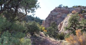
My friends and I used to take our .22s across the river and assault hundreds of rocks.  Our wandering took us across the National Monument boundary into Kodel’s Canyon.  Nobody went there in those days so we didn’t worry about having illegal guns in the park.  The canyon was smaller than the others, but we had the place to ourselves.  The approach is a deeply eroded plain of Dakota Sandstone from the river to the canyon.  The Cretaceous Dakota grades off to the Mancos Shale of the Grand Valley floor.

Kodel’s Canyon

That Mancos Shale is usually called Stinking Desert by many.  It is somewhat infertile unless well drained, and results in mostly barren gray flats.  Lots of barren gray flats from central Utah to Delta, Colorado.  With water and good drainage to carry the salt away, it can be farmland.  We would leave home on the valley floor and climb into the red rock Kodel’s Canyon.  At the mouth of the Canyon is the Kodel’s Canyon fault, where the Uncompahgre Uplift shoved all those Older Jurassic red rocks above the Cretaceous Valley.

Looking at the Grand Valley from Colorado National Monument

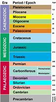
The bottom of the canyon is smooth rounded granite and schist geologists call basement rocks.  They are seldom found exposed on the Colorado Plateau, covered by thousands of feet of sedimentary rocks.  The time gap between those old basement rocks and the sedimentary rocks sitting on them is over a billion years.  It’s called the Great Unconformity, where all the rocks deposited during that billion years were eroded away.  This gap is found in many places worldwide, but there are also many places where the rocks missing in our canyon were deposited and remain to be seen and enjoy.  Think the Flatirons, Red Rocks, and the Garden of the Gods, all Cambrian.  Those rocks sit on Precambrian Gneiss and Schist 1.7 billion years old.

Those old rounded black rocks are great for climbing and we did it.  Today it’s called bouldering.  We didn’t have climbing ropes, so we used our .22s as climbing aids.  Dangerous?  Yes. Fun? You bet.

Among the guys I grew up with, only one had any injury running around across the river.  Jerry had a seriously sprained ankle.  The two guys with him helped him down to the road and help.  He exploited the ankle to excess.  At Boy Scouts we always played Capture the Flag after the meeting.  Jerry would hobble down to get the flag defying anyone to stop him.  I walked over and pushed him down.  I don’t think he ever forgave me.

Terremoto

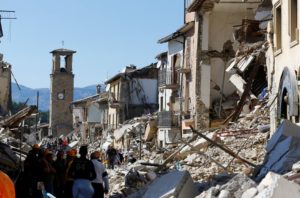
I was sitting in a building in the San Jose, Costa Rica airport waiting for my luggage when the building shook.  A soccer game was on the TV, and the guys just looked up and grinned at one another.  It wasn’t much of an earthquake, but Costa Rica has had some big ones.  It’s a mountainous country, and in 1991 a big one closed the road and railroad from San Jose to the Caribbean coast for weeks.

Typically, earthquakes happen where tectonic plates collide.  In Costa Rica it is the Cocos Plate diving (subducting) under the Caribbean Plate.  The  Cocos is headed east, the Caribbean is moving west.  The combined motion makes for some real fireworks.  The boundary is marked by a string of Volcanos.  The only active volcano I have visited is Irazu, northeast of San Jose.  It is a big tourist attraction and showered ash on President Kennedy in March of 1963.  I developed more of an appreciation of a volcano’s power when I looked into the crater.

Volcanos and earthquakes release energy on a scale that overwhelms the human imagination.  The nation of Japan moved about eight feet east feet during the 2011 earthquake which caused the tsunami responsible for inundating the east coast of the island.  Sea level rose about ten feet.  Now that, folks, is one hell of a shove.

Economic loss was in the neighborhood of $235 billion, the costliest natural disaster ever.  The magnitude was 9.1, about as big as they get.  Remember the scale is logarithmic, with the amplitude increasing by a factor of ten when moving from number to another.  Thus a magnitude increase from four to to nine is 500 times more intense.  The energy release is not on the order of ten times, but closer to thirty times.  You do the math.  It is enough energy to change the rotational speed and tilt of the earth.

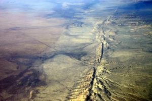
The southern end of our old friend the San Andreas fault is overdue for a major slip.  The northern portion is less likely as several good sized quakes have released much of the stored energy.    Estimates of the magnitude of a big one on the southern segment are in the range of 8.0.   Not as bad as the Japan shake, but enough to more than $200 billion, with major loss of life.  That Los Angeles Basin is full of people and stuff.  A big quake would trap most of the people there with no power or water.  Can you imagine no superhero movies for many months?

Christmas brought me several good books, including one on earthquakes and one on wildfire.  Brace yourself for disaster stories.  What is clear to me from my studies on wildfire and earthquakes is that there is risk to living on this planet.  Humanity only serves to magnify the rise.   We want our surroundings to be fairly steady state.  Not so, the driving force is change.  Whether natural phenomena or human caused. It will all change and then we die.  The key is to make life worthwhile, accepting the inevitability of change.  In the meantime, try to avoid Southern California if you can.

Weird Wyoming

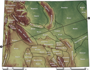
Along with having the entire atmosphere pass through the state in any 24 hour period, Wyoming has some other attributes beside the wind.  I like Wyoming for its diversity and the fact it doesn’t have too many people.  The diversity also extends to the geology. Prairie in the east, Devil’s Tower and the beautiful country around there to some of the most spectacular alpine country anywhere, even if the mountains are lower than ours in Colorado.  Oh, and Yellowstone, our first National Park.

Wyoming Geology

I especially like the deserts, like the Great Divide Basin, aka the Red Desert, a depression rimmed by the Continental Divide.   Yellowstone is the largest and most dangerous volcano in the country.  There is coal, iron ore, oil and gas, uranium, and trona, to name a few.  Those resources are a double edged sword, leading to a boom and bust economy.  Ranching just soldiers along,  but it is a hard way to make a living.

A good portion of the economy comes from Greens (Coloradans, known for their green license plates).  It’s the topography that draws me.  Rivers flowing north, through mountain ranges, fed by hot springs.  A range of hills known as the gas hills, where methane comes out of the ground.  Mountain ranges running north and south as God intended, but the Snowy Range runs east-west and is the boundary between the ancient island arcs known as Colorado and the much more ancient Wyoming Craton.

The Wyoming Craton has some of the oldest rocks in North America, sharing the antiquity with the Canadian Shield.  Ages vary but are around 2.6 to 2.8 billion years old.  The oldest rocks in Colorado are around 1.7 billion years old and arrived as an island arc smashing into Wyoming, much as Indonesia and the Philippines are headed to Asia.

Wyoming has had a lot of activity down deep, shoving mountains up and sliding them around.  That pushing and shoving means areas where oil and gas get concentrated in the bends and corners, thus all the oil patch work there.  There is a lot of coal. The Union Pacific got its coal right near the tracks, and there is a tremendous amount of coal in the Powder River basin.  Coal is out of favor now, so Gillette is hurting, people leaving.

The reason Wyoming got famous is for two reasons, unruly Indians and the livestock business.  There was a lot of Indian fighting in the middle of the nineteenth century, what with the Oregon Trail crossing the region.  When the Indians were whipped, all that empty country became home to cattle and sheep.  The livestock people still hold most of the political power – they also have oil and gas leases, so they aren’t very environment friendly.  Lots of cowboy legends came out of the place.

My favorite things are the rivers running through mountain ranges.  The textbook example are the Wind and Bighorn rivers.  They got their names because early explorers didn’t realize they are the same stream bisected by the Hot Springs Mountains.  The Bighorn flows south through Thermopolis and its hot springs and roses into a beautiful narrow canyon.  The Wind River flows out of the canyon.  The river was there, the mountains came up, and the river (rivers?) stayed in the same place, cutting the canyon as the uplift occurred.

Do I need to say the Wind River is aptly named?  Years ago in Colorado Springs I met a bicyclist doing a ride across the country.  He came across Wyoming.  He looked at me and in awe said,  “The Wind”.  He rode into the wind all across the state.  Another time I was driving from Laramie to Fort Collins after dark. It was Christmas time and the ground blizzard was in full song. I saw a VW bus along the road near Tie Siding. In conditions like that, you stop.  The occupant was from Australia and said “I’ve never encountered weather like this.”  It was around zero with 50 mph wind.  The VW had quit, probably a frozen gas line, and his wife got a ride into town to get help.  Shock and awe.  I just laughed and saw he was OK.  You know about the Wyoming Wind Gauge.  It’s a length of heavy chain hanging from a post.

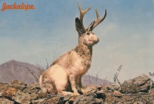
Jackalope,, Wyoming State Animal

There is usually a Jackalope colony nearby.

There are three books I recommend:

Rising From the Plains, John McPhee; Roadside Guide to Wyoming Geology; and Wyoming Geologic Highway Map

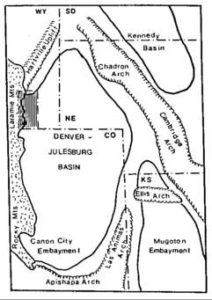
Denver Basin

Denver Basin

The Denver Basin is a deep syncline just east of the Southern Rocky Mountains.  It started around 300 million years ago when the Ancestral Rocky Mountains were uplifted.  A little plate tectonics here, folks.  A tectonic plate is a huge plate of rock slowly moving on the earth’s mantle at or near the surface. When two tectonic plates collide, one of them often dives beneath the other.  As the plate subsides, it runs into hotter rocks at depth.  The subsiding plate has lots of water which lowers the melting point of the rock.  Then things really go on the move.

The subsidence zone, usually along a coastline, gets pretty active, meaning earthquakes, volcanos, and the intrusion of huge blobs of granite known as plutons.  New rock coming in from below means the overlying rocks get uplifted into mountain ranges.  The other side of this mountain building is known as the foreland and usually subsides as its mass goes into the new mountains.  As it subsides, the new basin fills with debris eroding from the mountains.

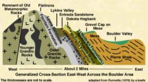
The Flatirons, Dakota Ridge, the Garden of the Gods, all are built from rocks buried thousands of feet deep just a few miles from the outcrops.  I am sitting here writing atop thousands of feet of mountain debris.

The mountains eventually get hauled away in rivers or dumped into the basin.  This happened twice here in my home country.  The second event occurred at the end of the Cretaceous and the early Paleogene, about 60 million years ago.  Our current Rockies came up, known as the Laramide Orogeny, came up again, and the foreland deepened even more.  It ended up being about 13000 feet deep, filled with the stuff washed and blown off the mountains.

This all took a while.  Rivers formed, seas came and went, and lots of life contributed organic material to the basin.  The result?  Coal, oil, and gas.  The first oil well was in Boulder County, producing from fractured Pierre Shale, which was deposited by an inland sea.  Now this Basin is big, extending into Nebraska and Wyoming.  Huge amounts of oil and gas have been produced, and horizontal drilling and fracking are releasing even more.  The Denver Basin is an oil patch.

Water from the mountains also entered the basin, creating aquifers producing lots of water.  We pump the water and because it is in an enclosed basin, it doesn’t recharge as fast as it is pumped.  Douglas County is going to run out of groundwater some day.  Then the water will have to come from the rivers, and the supply is limited.  Thus, seemingly crazy proposals to pump water from Flaming Gorge Reservoir on the Green River in northern Utah to Eastern Colorado.  Problem: California and Arizona also want that water.

Climate change has the potential of reducing the available water as well, eventually ending population growth.  Amazon, Stay Away.  Mining started Colorado development, and today the money still comes from the ground, but is from oil and gas. As we transition to alternate energy sources, where is Colorado’s wealth going to come from?

« Older Entries