The Enigma of the Colorado Plateau
 Although I have lived somewhere along Front Range Colorado most of my life, I still think of the Colorado Plateau as home. I am dedicated to the region because of its Geology. All that rock is just sitting there looking at you. There aren’t too many plants to get in the way. I grew up looking at the red rock of the Colorado National Monument just across the river from home.
Thing is, the red rock is mostly from the Mesozoic. There is a lot of boring buff colored rock from the Cenozoic, notably the Green River Formation. The Green River Isn’t much to look at, but it has a huge present day impact. Look at my piece on the Formation in Categories.
I am currently interested in the time after the Green River Formation was deposited. The literature on this time on the Plateau is relatively sparse, mostly because it was more a time of erosion, not deposition. A large part of the deposition was in fresh water lakes with only remnants of the sediments today. Those red rocks forming canyons and arches get all the press.
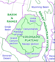
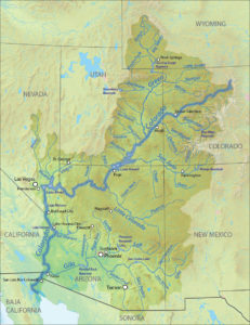
 For most of its existence, the Colorado Plateau had no outlet to the sea. Then, a bit less than six million years ago. The Colorado River decided to head for Baja California. There have been lots of explanations for this happening, but they boil down to elevation change. The Plateau ended up higher than the Basin and Range province to the west. That area was once a highland, but big tectonic forces changed everything. Then, a stream eroding east carved enough of a canyon to capture the Colorado Plateau drainage which became the Colorado River.
As you are aware, the Pacific Plate is colliding with the North American plate. The collision is not at right angles, the Pacific Plate is headed northeast. As it slides along, it pulls on the North American plate, somewhat pulling it apart. The area east of the Sierras known as the Basin and Range is being stretched. As it stretches, big blocks called grabens drop down, leaving mountain ranges between them. The area ended up lower than the Colorado Plateau.
It’s not entirely clear if The Plateau was uplifted during this time by remnants of the same forces responsible for creating the Rocky Mountains. It seems to me the uplift was earlier, but my reading on the issue is not conclusive. The fact is the Plateau ended up higher than the Basin and Range. Erosion then began digging away in the area west of Grand Canyon, hooking up with the internal drainage of the Plateau. Canyon cutting began.
All those spectacular canyons are younger than six million years. An interesting sidelight is that the stretching of the Basin and Range continues, and the Colorado Plateau is slowly rotating clockwise. The question for me is why is the Plateau still in one piece? Compression, stretching, rising magma, new mountains, collapsing Nevada, huge volcanic fields, Arizona mountains wearing away, all this stuff going on all over the neighborhood, but this one slab mostly stays in one piece. Why?
My personal hypothesis is, as the Plateau houses the Center of the Universe, it necessarily stays in one piece. I haven’t found anything in the literature to support this, so we will look at some other explanations. By the way, the Center of the Universe is within a 100 mile radius from the confluence of the Green and the Colorado. Let me know if you find it.
In the meantime we will see what the geologists have to say. Usually they reach some consensus, except here.
If you want to explore all this on your own: Carving Grand Canyon, by Wayne Ranney and Geological Evolution of the Colorado Plateau of Western Colorado and Eastern Utah… by Robert Fillmore.
