Category Archives: Federal Land

Rocky Flats

Rocky Flats

Rocky Flats

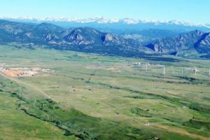
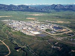
 What is now is the Rocky Flats National Wildlife Refuge once was the Rocky Flats Plant where triggers for nuclear weapons were manufactured.  The main raw ingredient for the triggers was plutonium, one of the most toxic and radioactive substances known, with a half-life of over 4000 years.  During the forty years the plant operated, there were two major fires in glove boxes where plutonium discs were handled.  In this and other incidents, many pounds of plutonium were released.  The Wikipedia article has an excellent summary and bibliography.   

I was talking to a woman recently about Rocky Flats.  Her father worked there for several years when the plant was in full operation.  He had to deal with a glove box where the plutonium had started to burn.  The gloves were so hot he had to wear other gloves before he could put his hands into the glove box gloves to stop the reaction.  He probably saved some lives.  He died of cancer. 

I became more interested in Rocky Flats after reading Full Body Burden, by Kristin Iverson, an English Professor who grew up in the area.  The book is controversial, disagreeing with the environmental assessments by the Colorado Department of Public Health and Environment and the Nuclear Regulatory Commission.  Given all I have read, I am skeptical of the official lint that the area is safe, and exposure to the public was and is minimal.  Decide for yourself. 

Iverson writes that a large area of contaminated topsoil was covered with more topsoil and pronounced safe.  Rocky Flats is aptly named, as millions of tons of glacial erosion products have covered the area with gravel.  The surface is called ground armor, mostly rock, as the high winds in the area have blown much of the finer material away.  That continues, and rodents burrowing bring buried soil to the surface where it blows into the Denver Metro area..  

The nearby Standley Lake, a large irrigation reservoir that provides water to Westminster and Broomfield, allows boating and water skiing but bans swimming because the lake bottom is contaminated with plutonium.  Many experts have advocated banning development in the area, but houses are going up. 

I got interested again recently because the NOAA National Weather Radar website is my go-to means of weather monitoring.  The TV weather people are either warning the apocalypse is imminent or it is fine, no rain, just before a major hailstorm.  Over a period of months I noticed a nearly constant radar image indicating precipitation over the NWR.  Day or night, weekends or weekdays, the image is there.  If it really is rain, the refuge would be a major swamp at the base of the Rocky Mountains.   

Many years ago I was a radar repairman in the Army.  One of the radars we maintained put out so much radio frequency energy it would kill birds flying in front.  We had quite a bit of training about ionizing radiation.  Radars emit radiation, so does decaying plutonium.  I could not come up with any explanation for the radar image other than radioactive decay.  This would be  disastrous, as much of the Denver metro area is downwind of Rocky Flats.   

I sent a number of emails to the NWS, TV stations, and the CDPHE.  I guess I stirred things up a bit, because I got a long, thoughtful letter from CDPHE outlining the investigation I generated.  The conclusion reached is that the radar image is from dust coming from a gravel mining and crushing operation just adjacent to the refuge.   Here is the letter:

Begin forwarded message:

From: “Spreng, Carl” <carl.spreng@state.co.us>
Date: July 13, 2016 at 3:56:58 PM MDT
To: levanks@me.com
Cc: Phillip Peterson – CDPHE <phillip.peterson@state.co.us>, Surovchak Scott <Scott.Surovchak@lm.doe.gov>, “Moritz, Vera” <Moritz.Vera@epa.gov>, Lindsay Masters – CDPHE <lindsay.masters@state.co.us>, Darr Bob <Bob.Darr@lm.doe.gov>, Rob Beierle – CDPHE <robert.beierle@state.co.us>, Smith Warren <warren.smith@state.co.us>
Subject: Rocky Flats

William Shanks

Mr. Shanks,

Your message sent to Phill Peterson in our Radiation Control Program was forwarded to me for response. I discussed your observations with a representative of NOAA. NOAA scientists apparently notice a fairly consistent dust cloud in the Rocky Flats area. This is consistent with the adjacent gravel operations — current and historic. You can observe the dust that rises off these operations as you drive by the site.
During remediation, the source areas of radiological risk in the Central Operable Unit (managed by the US Dept. of Energy) were excavated and shipped out of state. The human health risks inside the Central Operable Unit and the remainder of the site (managed as a refuge by the US Fish and Wildlife Service) were assessed following remediation and risks were found to be very low. A final decision for the site declared that any conceivable use would be appropriate in the Refuge area. That decision was based on an enormous amount of data (surface soil, subsurface soil, groundwater, surface water, air). After the remediation was completed, an aerial survey was conducted using a low-flying helicopter with detectors.
Offsite areas in the vicinity of Rocky Flats are also safe for any use. Numerous offsite surveys confirm the conclusion that only a few samples just east of Rocky Flats detected plutonium concentrations above background levels. You can read more information about the sampling on and around Rocky Flats on the Colorado Dept. of Public Health and Environment’s (CDPHE) web page at:  http://www.cdphe.state.co.us/hm/rf/index.htm.
 
Please contact us again if you have more questions.


Carl Spreng
P 303.692.3358  |  F 303.759.5355  |  C 303-328-7289
4300 Cherry Creek Drive S, Denver, CO  80246-1530
———- Forwarded message ———-
From: Carol Leavenworth <levanks@me.com>
Date: Tue, Jul 5, 2016 at 12:39 PM
Subject: Rocky Flats
To: phillip.peterson@state.co.us


Sir,
I notice there is a consistent radar image over the Rocky Flats NWR when viewing the NOAA national weather radar website.  I am no physicist, but ionizing radiation is detectable by radar.  Is this the case at Rocky Flats?  Is there a radiation hazard outside the closed zone?  Is there a public health risk for the nearby residential areas?I was a radar repairman in the Army in the 1960’s and remain interested in the field.  There weren’t many RF energy safeguards back then and there were nuclear weapons stored where I was stationed in Germany.
Thanks.
William Shanks
2032 S. Logan St.
Denver CO 80210
303-830-0599

After Cleanup

After Cleanup

I was skeptical, so I drove out there.  I made a couple of circuits around the area, passing through new subdivisions where grading was going on and decided that was not the source.  I then turned off SH 93, the road from Golden to Boulder into what used to be the west gate to the bomb plant.  I went past lots of no trespassing signs to a big gravel mining and crushing operation.  The crusher was producing a significant dust cloud.  There were lots of big gravel trucks, indicating a major operation.    

I left without getting stopped for trespassing and made another lap around the refuge.  The gravel operation is to the southwest of the refuge, and I could see the dust cloud from north of the refuge.  Mystery solved.  it is not ionizing radiation creating the radar image, it is dust.  

There is no radioactive cloud coming off Rocky Flats.  There is, however, still a lot of radioactive and chemical pollution out there.  I suggest you not buy one of the nice new houses being built in the area..  
rat in cage two bottles

The World Famous Green River Formation, for oil shale, not beauty

The World Famous Green River Formation, for oil shale, not beauty

About fifty million years ago the Grand Canyon and the Colorado River did not exist.  The area was surrounded by the Wind River Mountains, the Uintah Mountains, the San Juans, the Uncompahgre Plateau, and the newly formed Rocky Mountains.  This huge area had no outlet to the sea.  The climate was similar to our current Gulf Coast, warm and moist.  During the six million years we are exploring, things changed.  Lakes formed and receded, land rose and subsided, and through all this the surrounding highlands were sending their sediment into the lakes.   

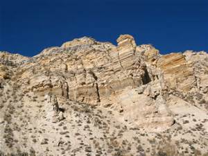
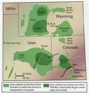
The Green River Formation is the result of all the sedimentation.  It is up to ten kilometers in depth, thinner at the margins.  At first the lakes were fresh water, but later became saline, leaving large deposits of carbonate rocks.  The trona deposits at Green River, Wyoming are some of the richest in the world.  The margins are sandstone and conglomerate interlaced with the fine silt that filled most of the basin.  The formation is rich in the fossils of the abundant life in the lakes.  They are world famous for their variety and abundance.   

There was an anoxic layer at the bottom that preserved the organisms settling there.  The lakes were abundant in blue-green algae.  The remains of the algae are the source of the oil shale deposits the region is known for.  The oil shale is there in millions of barrels, but it is expensive to extract the petroleum from the rock.  It may never be commercially viable, but the formation has been extensively studied as a result.  

Green River Formation Map

Green River Formation Map

Standing in my home town of Fruita looking north, the white cliffs behind the Book Cliffs are the Green River Formation.  The Roan Plateau is huge, but does not attract visitors like the red rock country to the south.  A huge exposure is the highlands west of I-70 from Rifle to DeBeque Canyon. 

My interest is from visiting ranchers and hunting in the Douglas Pass area in my youth.  Most of our visits were to ranches in the Green River Formation.  The elevations varied greatly.  The ranches were along West Salt Creek, but there were back country roads that went from sagebrush desert to piñon-juniper to oak brush shaly hillsides with sandstone rims to high country timber with world class mud.  In fact, the mud is world class everywhere in the region. 

Back before four wheel drive became common, there was a pile of rocks at the bottom of every big hill.  Load them in the back of your pickup, go where you planned, and unload them on the way home.  There is a network of canyons with side canyons branching off.  All of it is fine deer habitat.  My favorite places were at the head of a canyon with the wind in my face and a view of the LaSal Mountains and the Uncompahgre Plateau in the distance.  Flat, wooded country gives me the creeps. 

Access to a lot of the country is difficult.  Most of the land is BLM land, but the early ranchers homesteaded the choice land that had water.  The private land meant locked gates.  We knew some of the ranchers, family friends.  Hunting season was a big deal.  There were maybe a dozen or more people, hunting during the day and drinking and playing poker at night.  The big ranch house had a big kitchen with a wood burning stove along with the stove in the big main room.  There was a light plant in the shed next to the house.  It looked like no generator you see these days.  There were also lots of Coleman lanterns when the light plant failed.  Good times and lots of venison.  The unheated bunkhouse was upstairs. 

Douglas pass was up the main road, gravel in those days.  It isn’t that high by Colorado standards, but made up for it with the switchbacks up the head of the canyon to the summit up through that shale.  When the shale is wet, it moves.  The road trapped the runoff, wetting the soft shale, and most every spring one or more places slid.  The mountainside now is braided with old road cuts.  It wasn’t much of a main road in the 1950’s, but now there is so much oil and gas development that the road is a paved state highway that the highway department spends money on. 

The road crosses the desert above the Highline irrigation canal before it goes into the canyon.  It is on the Mancos shale, responsible for all that flat desert in Colorado and Utah that turns to grease when it is wet.  There was one hill the road went over then descended into the wash on the north side.  That meant the road was on a north facing slope for a distance.  That hill was named Coyote, because it could bite and gnaw on you if it was wet.  A bit farther north was a ten or twelve foot high rock on the side of the road, all by itself.  

The county employee maintaining the road in those days had his grader blade scrape on that rock every time he bladed the road.  It would leave a bump, so he would have to drag dirt over to level things out.  One day he got fed up and dug that rock up and moved it off the road.  It was probably a two day project, but he never had to fight that damn rock again. 

After I could drive, I ran around that desert quite a bit.  I learned how to drive a two wheel drive pickup in that greasy stuff from my father.  He was the telephone man in Fruita, responsible for maintaining the toll line as far as Cisco, Utah.  That meant navigating two ruts through the cheat grass and sagebrush.  He could put a two wheel drive pickup into places that were a challenge for a Jeep.  Rocks in the back, chains if needed, put it in second gear and putt along.  He seldom used the granny gear or used the gas pedal.  Those old Chevy sixes would just lug their way along.   

I am as guilty as any back country explorer for spending most of my time in the Rocky Mountains or the Utah red rock country, but the Mancos Shale and the Green River formation are calling me.  I just need to see if my tire chains are in good shape.  I think I will go over Douglas Pass, loop around and look the Piceance Basin over. From Rifle I will go down to Plateau Creek (my father and grandfather said platoo crick) and up to Collbran to look at the big slide.

Armed Insurrection

Ammon Bundy and the Boys

Ammon Bundy and the Boys

Currently we are following the occupation of a federal wildlife refuge by a group of men quoting the Constitution and claiming the land for incarcerated ranchers who do not support the occupation.  The real reason for the occupation is to attempt to force the federal government to relinquish all the public lands in the west to private ownership.   

The premise is that the land should be owned by the local residents for their benefit.  For many years in the rural west, the local ranchers acted as if the land was theirs.  They ran their livestock, built reservoirs and roads, and built fences.   

At first, the policy of the government was to encourage settlement with the Homestead Act, land grants to railroads along their rights-of-way, and direct sales.  As population increased, the policies began changing.  The Grazing Service leased land for livestock grazing at very low rates, in effect subsidizing the industry.  Many ranchers got rich.  They would homestead the water and run their stock on government land.  As their land ownership increased by various means, they became the major taxpayers in many rural counties.  As the big landowners they tended to control the local governments. 

In 1949, President Truman created the Bureau of Land Management (BLM) also known as the Bureau of Livestock and Mining.  The Forest Service policies were similar, cheap timber sales and low cost grazing leases.  In addition, anyone could stake a mining claim, prove it out, and own the land. 

The BLM and the USFS were understaffed, with many of their employees second or third sons of ranching families who went to the Forestry Departments in the cow colleges.  The net effect was to encourage rampant cheating, cutting more timber, running more stock, and damaging the ecosystems. 

Delta - Grand Junction Colorado Desert

Delta – Grand Junction Colorado Desert

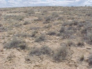
My father told of the lush grass growing between Grand Junction and Delta, Colorado when he was young.  The grass is gone, the area is desolate.  There is more sagebrush today than before the land was settled.  Sagebrush is resistant to trampling.  The deep, steep walled gullies all over the west are recent, caused by erosion caused by the loss of root systems that held the soil. 

Today all that has changed.  The BLM and the Forest Service actively manage the lands.  The populations are much larger, with much of the rural west not so rural.  Ranchers can no longer treat public lands as their own.  Many of them refuse to accept the changes, and the Malheur occupation is the result. 

The occupiers are the spear point of a movement of disenchanted mostly rural people who resent governmental control of land they tend to see as their birthright.  The rural people are fiercely independent.  They do not like cities, don’t want others telling them what to do, and want to use the grass and timber that surrounds them.  They are usually very conservative politically. 

There are not many ways to make a living in those areas.  The land is either owned by a few ranchers or the government.  There are government jobs with the BLM or the Forest Service, schools, county road maintenance, the state highway department, or low paying service and retail jobs in town.  Most of the young people move away. 

I am one of the ones who moved away.  I was a town kid, but the same conditions applied to me.  The best job I had before I left was with the National Park Service, and was seasonal, as many of the trade related jobs are.  I worked for the Park Service, went to school and the army, returned to go to school at the local Junior College, transferred to a University in the city, and return only for visits.  That is the story for much of my high school class, even with growing Grand Junction just down the road. 

In the rural west that is the story.  Locals who just scrape along, the ranchers, and all that beautiful government land surrounding them.  They won’t or can’t make it in the city and feel trapped in a situation beyond their control.  Some of them turn to hard line right-wing politics facilitated by online websites.  In addition, almost every television set is tuned to sports or Fox News.  

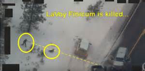
The Feds have yet to come up with a consistent policy to deal with militants

LaVoy Finicum Shot

LaVoy Finicum Shot

like the Bundys and their allies.  They must deal with the lawlessness, but do not want a situation like Ruby Ridge or Waco.  Thus they do nothing, which encourages the militias, or precipitate a violent confrontation with loss of life.  The dilemma is how to deal with an armed insurrection without gunfire.  Many of the rebels are sworn to die fighting.  Must that happen?  Letting the nuts go is unacceptable.  Letting them run loose while occupying government land and trying to arrest them when they leave has led to killing.  My thought is to lay siege and starve them out.  They failed at Waco when the Feds lost patience.  Lots of innocent lives were lost.  The problem is that the law enforcement agencies tend to lack patience.   

Maybe the solution is to have an interagency federal siege team, trained to deal with armed standoffs.  They have their government salaries while the insurrectionists can be isolated from their outside support.  No power, no food, no water, they won’t last long.  Outside militants may try to lift the siege, but the government has the resources to surround and isolate them as well.  Will there be shooting?  Probably, as many of the militants are glory seekers, willing to be martyrs.  When the occupations all fail, the movements will lose their motivation.  Maybe.  As long as the militants are able to arm themselves, these occupations will probably continue.  As we saw, road stops do not work.