Category Archives: Pipelines

rat in cage two bottles

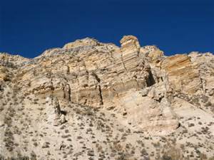
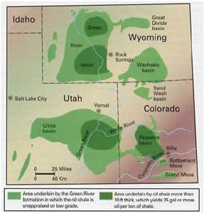
The World Famous Green River Formation, for oil shale, not beauty

The World Famous Green River Formation, for oil shale, not beauty

About fifty million years ago the Grand Canyon and the Colorado River did not exist.  The area was surrounded by the Wind River Mountains, the Uintah Mountains, the San Juans, the Uncompahgre Plateau, and the newly formed Rocky Mountains.  This huge area had no outlet to the sea.  The climate was similar to our current Gulf Coast, warm and moist.  During the six million years we are exploring, things changed.  Lakes formed and receded, land rose and subsided, and through all this the surrounding highlands were sending their sediment into the lakes.   

The Green River Formation is the result of all the sedimentation.  It is up to ten kilometers in depth, thinner at the margins.  At first the lakes were fresh water, but later became saline, leaving large deposits of carbonate rocks.  The trona deposits at Green River, Wyoming are some of the richest in the world.  The margins are sandstone and conglomerate interlaced with the fine silt that filled most of the basin.  The formation is rich in the fossils of the abundant life in the lakes.  They are world famous for their variety and abundance.   

There was an anoxic layer at the bottom that preserved the organisms settling there.  The lakes were abundant in blue-green algae.  The remains of the algae are the source of the oil shale deposits the region is known for.  The oil shale is there in millions of barrels, but it is expensive to extract the petroleum from the rock.  It may never be commercially viable, but the formation has been extensively studied as a result.  

Green River Formation Map

Green River Formation Map

Standing in my home town of Fruita looking north, the white cliffs behind the Book Cliffs are the Green River Formation.  The Roan Plateau is huge, but does not attract visitors like the red rock country to the south.  A huge exposure is the highlands west of I-70 from Rifle to DeBeque Canyon. 

My interest is from visiting ranchers and hunting in the Douglas Pass area in my youth.  Most of our visits were to ranches in the Green River Formation.  The elevations varied greatly.  The ranches were along West Salt Creek, but there were back country roads that went from sagebrush desert to piñon-juniper to oak brush shaly hillsides with sandstone rims to high country timber with world class mud.  In fact, the mud is world class everywhere in the region. 

Back before four wheel drive became common, there was a pile of rocks at the bottom of every big hill.  Load them in the back of your pickup, go where you planned, and unload them on the way home.  There is a network of canyons with side canyons branching off.  All of it is fine deer habitat.  My favorite places were at the head of a canyon with the wind in my face and a view of the LaSal Mountains and the Uncompahgre Plateau in the distance.  Flat, wooded country gives me the creeps. 

Access to a lot of the country is difficult.  Most of the land is BLM land, but the early ranchers homesteaded the choice land that had water.  The private land meant locked gates.  We knew some of the ranchers, family friends.  Hunting season was a big deal.  There were maybe a dozen or more people, hunting during the day and drinking and playing poker at night.  The big ranch house had a big kitchen with a wood burning stove along with the stove in the big main room.  There was a light plant in the shed next to the house.  It looked like no generator you see these days.  There were also lots of Coleman lanterns when the light plant failed.  Good times and lots of venison.  The unheated bunkhouse was upstairs. 

Douglas pass was up the main road, gravel in those days.  It isn’t that high by Colorado standards, but made up for it with the switchbacks up the head of the canyon to the summit up through that shale.  When the shale is wet, it moves.  The road trapped the runoff, wetting the soft shale, and most every spring one or more places slid.  The mountainside now is braided with old road cuts.  It wasn’t much of a main road in the 1950’s, but now there is so much oil and gas development that the road is a paved state highway that the highway department spends money on. 

The road crosses the desert above the Highline irrigation canal before it goes into the canyon.  It is on the Mancos shale, responsible for all that flat desert in Colorado and Utah that turns to grease when it is wet.  There was one hill the road went over then descended into the wash on the north side.  That meant the road was on a north facing slope for a distance.  That hill was named Coyote, because it could bite and gnaw on you if it was wet.  A bit farther north was a ten or twelve foot high rock on the side of the road, all by itself.  

The county employee maintaining the road in those days had his grader blade scrape on that rock every time he bladed the road.  It would leave a bump, so he would have to drag dirt over to level things out.  One day he got fed up and dug that rock up and moved it off the road.  It was probably a two day project, but he never had to fight that damn rock again. 

After I could drive, I ran around that desert quite a bit.  I learned how to drive a two wheel drive pickup in that greasy stuff from my father.  He was the telephone man in Fruita, responsible for maintaining the toll line as far as Cisco, Utah.  That meant navigating two ruts through the cheat grass and sagebrush.  He could put a two wheel drive pickup into places that were a challenge for a Jeep.  Rocks in the back, chains if needed, put it in second gear and putt along.  He seldom used the granny gear or used the gas pedal.  Those old Chevy sixes would just lug their way along.   

I am as guilty as any back country explorer for spending most of my time in the Rocky Mountains or the Utah red rock country, but the Mancos Shale and the Green River formation are calling me.  I just need to see if my tire chains are in good shape.  I think I will go over Douglas Pass, loop around and look the Piceance Basin over. From Rifle I will go down to Plateau Creek (my father and grandfather said platoo crick) and up to Collbran to look at the big slide.
More On Flint Water

Flint Water

Flint Water

The tragedy of Flint, Michigan water continues.  Most people in our country take water for granted.  Turn the handle and clean, safe water comes out.  There is a bill to pay every quarter or month, but it is not very expensive.  If you are having paying, the water provider will work with you. 

When a Flint resident turns the handle, red, turbid water high in lead comes out.  It is not safe to drink and is dangerous for bathing and dishwashing.  When it is water bill time, Flint has the highest water rates in the country.  People are paying a lot of money to damage their brains. 

There was a Legionnaires Disease outbreak which killed nine people and sickened many others.   Legionnaires Disease is waterborne, usually from the aerosol from showers in buildings  using a recirculating warm water system using cooling towers or rooftop storage tanks.  The bacterium is often present in drinking water along with other bacteria and viruses in low numbers.  

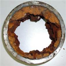
Disinfection in water treatment is intended to kill pathogenic organisms in the water.  It does not sterilize the water.  Given proper conditions, those organisms can multiply enough to pose a public health problem.     The big ones are the cooling towers and storage tanks.  Another potential source are the rusty accumulations called tubercles in old cast iron pipes.  This is usually not a big problem because the bacteria are contained in the tubercles.   

Water Main Tubercles

Water Main Tubercles

When the water chemistry changes, making the water more corrosive, the tubercles break down, making red water and releasing the accumulated pathogens.  The water leaving the treatment plant is safe, but corrosive conditions in the distribution system release lead from old lead service lines running to houses that have lost their protective coating;  and pathogens are released from tubercules breaking down in the water mains. 

The potable water industry is highly regulated.  The utility itself is mandated to treat and test the water to insure its safety.  This includes testing water from individual taps in the distribution system.  County health departments also regularly test drinking water.  State Health Departments are also equipped to monitor water quality, although normally they rely on reports from the providers.  All this is overseen by EPA under the Safe Drinking Water Act.  The Centers For Disease Control also respond when unusual outbreaks occur. 

This is a lot of regulation and a lot of bureaucracy.  Usually the agencies work well together, as they share the same mission, assuring the water is safe.  The system broke down in Michigan when the state government assumed control of local cities facing a budget crisis.  The emphasis shifted from providing safe water to saving money.  The money savers were not water people and tended to ignore those reporting the unsafe water.  Instead of interagency cooperation, distrust arose.   

Flint is a city in crisis.  It once was a General Motors town, with lots of good paying jobs.  Many of those jobs are gone, the people who could afford to moved away.  Those left are poor and mostly black, with little political influence.  A toxic governmental situation created a toxic water situation.   

A main role of government is to protect the health and safety of the people.  It seems the Michigan state government avoided responsibility in order to save money.  There seems to be a large movement in our country to reduce the size of government.  This cost saving often comes at the expense of infrastructure.  As the roads, bridges, water and sewer systems, schools, police and fire departments decay, the quality of life of the citizens also decays.  All this did not seem to matter in Flint or the rest of Michigan, because the citizens affected tended to be poor and black.

Part Three, the Keystone XL Pipeline

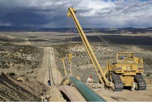
Pipeline Construction

Pipeline Construction

When I was growing up in Fruita, Colorado in the 1950’s, the El Paso Natural Gas Company built a 26″ natural gas pipeline from north to south through Western Colorado. In flat country, laying a pipe is fairly straightforward.  To lay a pipeline, dig, lay pipe, weld, wrap, and backfill.  In the Colorado Plateau, the pipeline not only goes from point to point, it goes up and down.

North of Fruita, The line had to go over Douglas Pass. As Colorado passes go, it is no big deal.   Not that high, but near the top there is steep and unstable ground famous for landslides.  The trenchers, welding machines, side-boom tractors handling pipe, and bulldozers; all had to be winched up and down the mountainside.  That is a slow, expensive process. To us in Fruita, it meant that our little town had lots of pipeliners for several weeks.

I mostly saw the pipeliners in Hill’s Cafe, where we often had dinner. The stereotype is that pipeliners are a wild bunch, but we didn’t see it in the cafe.  They were quiet, well-behaved, some prayed before eating, and I liked them.  After all, if you are from Bald Knob, Arkansas, how wild can you be?

That pipeline brings gas from Wyoming, Western Colorado, and Eastern Utah to markets in Texas and the southwest, including California. To my knowledge, it has few problems and quietly does its job.  I think that pipeline has shaped my thinking about pipelines in general.

Today there is much oil and gas development in North Dakota and Alberta. A pipeline network exists to deliver crude oil from there to the refinery complex on the Gulf Coast.  It can’t deliver all that is being produced.  Proposed is a new line, the Keystone XL Pipeline that would run west of the existing line, picking up crude from the Williston Basin in North Dakota as well as the synthetic crude from the Alberta tar sands.

There is a lot of opposition for several reasons. One reason is fear of leaks.  Big spills, contamination, fire, ground water contamination, and all the risks that go with moving lots of nasty stuff that burns.  That Alberta synthetic crude is even nastier than regular crude.  Its carbon footprint is much higher than oil from traditional sources.  It is thick and has to be heated to separate it from the sand.  Most of the crude oil refined here in Denver is tar sand oil.

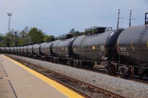
Oil Car Train

Oil Car Train

The fact is that as long as demand for petroleum products stays high, that Alberta crude will go south, but in rail cars if the pipeline isn’t built.  Here in Denver, there are many tank car trains headed south, competing with coal trains for right of way.   In the upper Midwest there is so much oil traffic that farmers are having difficulty shipping their grain.  Pipelines are safer than rail cars for shipping petroleum.

Some of the opposition is for environmental reasons. Tar sand crude is bad.  Pipelines are bad.  Fossil fuel is bad.  All true.  The solution is not stopping pipelines, but reducing demand.  How to reduce demand?  Make fossil fuels more expensive with higher taxes.  Use the tax money to develop alternative energy and transportation.  Build rails not freeways.  Tell that to Republican legislators.

In the meantime, I think the pipeline is the best alternative until our energy policies change.