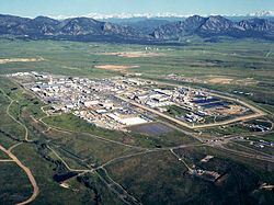
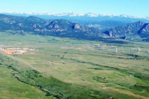
Category Archives: Wind

Eolian Deposition

Loess Caves in China

While studying a geography unit in grade school I was fascinated by the extensive deposits of loess in China.  Loess is fine wind-deposited soil.  In China, the loess covers a huge area in central China and is an important agricultural region.  The soil is fertile, easy to work, and when it erodes it can form steep cliffs.  People have carved homes into the cliffs for centuries, long enough to be included in geography books in western Colorado.  I lived in western Colorado cliff country, probably responsible for my interest in loess.

Loess is eolian soil, meaning it is wind deposited.  There is also wind deposited sand.  The Colorado National Monument, across the Colorado River from Fruita where I grew up has lots of eolian sandstone.  The cliff forming Wingate and the arch forming Entrada Sandstone are ancient sand dunes turned to stone.  My fascination for wind deposited cliffs comes naturally.

I now live east of the Rocky Mountains.  The mountains are tall and rugged, but are in the process of wearing away.  The Rockies have had several glacial periods.  Glaciers form, grind the mountains, then melt and leave their grinding as sand, silt, and gravel called glacial till. The more coarse debris often was carried in huge quantities onto the plains.  The  smaller particles, sand and silt, were blown onto the plains east of the eroding mountains.

The sand has created extensive sand hills on much of the plains in Colorado.  The sandy soil is thin and fragile, poor for farming, but fine for livestock grazing.  Interspersed among the sand hills are loess deposits now farmed extensively with water drawn from the Ogallala Aquifer in the Ogallala Sandstone, which was washed out of the mountains as the glaciers melted. The Ogallala extends from the mountains into Nebraska and south into the Texas Panhandle.

You may be aware the wind blows in Wyoming.  The entire atmosphere passes through Wyoming in any 24 hour period.  You have seen the Wyoming Wind Gauge?  It’s a logging chain hanging from a post.  I may exaggerate here, but not much.

While blowing, wind carries sand eastward out of the mountains. It also erodes the prairies in eastern Wyoming.  The sand ends up in the Western Nebraska Sand Hill country, covering over a quarter of the state.  The silt blew farther east, building loess deposits along the rivers.

In the dust bowl years in southeastern Colorado, northeastern New Mexico, southern Kansas, and the Texas and Oklahoma panhandles, the dust storms sent silt as far as Washington D.C.  Wind blown stuff is a big deal everywhere.  In North Africa, the sandy deserts are getting sandier as the silt is picked up and blows across the Atlantic Ocean, fertilizing the Amazon Basin.

In Denver, a car sitting outside for several days acquires a significant coat of wind blown dirt.  A couple of years ago, the dirt was red, meaning it originated in eastern Utah.   I notice my sidewalk is lower than the lawn by a couple of inches.  How much of it is organic accumulation and how much is eolian silt and sand?

I went for a long time thinking water is responsible for most of erosion.  It may be true, but don’t discount the wind, especially in Wyoming.

Wildfire Revisited

Ventura Fire

Things are hot in Southern California.  Earlier, it was hot in Santa Rosa and the Napa Valley.  When there is a high pressure system over the Great Basin and a low develops off the California Coast, the pressure gradient gives rise to hot downslope winds blowing from east to west.  The Santa Ana.  Wildfires proliferate in the mountainous chaparral country.  As the population continues to grow, the urban areas extend into the brush country.

That Great Basin high is also a fire maker for Colorado, Utah, New Mexico, and Arizona.  Here in Colorado, low pressure systems move down the Plains and the pressure gradient creates winds similar to California’s Santa Ana.  As with most natural phenomena, it is not if, but when.

It’s gonna burn, folks.

The brush country is that way because frequent wildfires prevent any significant tree growth.  When the brush burns, it tends to return in just a few years.  With trees, not so much.

Rawah Burn. Over 100 Years, Trees Have Not Returned

I remember backpacking through a 100 year old burn in the Rawah Wilderness here in Colorado.  The trees had not returned, and the topsoil was eroded away on the hilltops.  Fires in Colorado’s chaparral country such as west of Glenwood Springs burn and in five or ten years the brush is back, ready to burn again.

I have seen this happen in my lifetime.  The  ridges south of the Colorado River and west of Glenwood have burned at least twice.  Lightning causes some of the fires, but once a fire spread from the town dump.  The tragic 1994 fire that killed fourteen firefighters was north of the river and just west of Glenwood.  The fuel load was greater because the area had not burned for some time.


Storm King


If you go back to the Storm King fire area, you will see the brush returning.  It’s not ready to burn yet, but given some time and a few wet years, it will be ready to go again.  The town of Glenwood has built up right to the brush on both sides of the river.

Brush Returning

Back to California, the towns have grown up to the brush and those wanting a view are living in the brushy areas.  The canyons are more heavily wooded and full of houses.  All the coastal mountains from San Diego north are in the chaparral zone.  All the urbanization is also in those areas.  Quick commute? Live just below the hills in a canyon.  Nice view, build your house on the ridge.

Those examples of the urban-woodland interface are not unique to Western Colorado and California.  The Colorado Front Range is another example.  Fires have burned from west of Fort Collins to south of Colorado Springs.

Waldo Canyon Fire


The Waldo Canyon fire burned into town on Colorado Springs’ west side and into Manitou Springs.  The Black Forest Fire was in a different climate zone with Ponderosa Pine , but with lots of brush.  That area is wetter, but is also subject to drought and wildfire, just less often.

Arizona and Utah have similar country, and fire killed 19 firefighters in mixed brush and timber just outside Prescott.  I am waiting for a big fire just west of Denver.  It’s only going to get worse.  People are moving into the brush country in increasing numbers,  if you move to Colorado or California from Chicago, you want the mountain experience.  The jobs are in the cities, and the closest mountain areas are brush country.  Four Mile Canyon outside Boulder and Ojai, California are examples of what fire does to development in the chaparral.

Young people looking for an exciting career should look into wildland firefighting.  It is a growth industry.  Oh, I haven’t even mentioned climate change.  It will increase job opportunities.

Rocky Flats

Rocky Flats

Rocky Flats

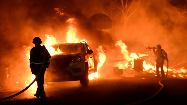
 What is now is the Rocky Flats National Wildlife Refuge once was the Rocky Flats Plant where triggers for nuclear weapons were manufactured.  The main raw ingredient for the triggers was plutonium, one of the most toxic and radioactive substances known, with a half-life of over 4000 years.  During the forty years the plant operated, there were two major fires in glove boxes where plutonium discs were handled.  In this and other incidents, many pounds of plutonium were released.  The Wikipedia article has an excellent summary and bibliography.   

I was talking to a woman recently about Rocky Flats.  Her father worked there for several years when the plant was in full operation.  He had to deal with a glove box where the plutonium had started to burn.  The gloves were so hot he had to wear other gloves before he could put his hands into the glove box gloves to stop the reaction.  He probably saved some lives.  He died of cancer. 

I became more interested in Rocky Flats after reading Full Body Burden, by Kristin Iverson, an English Professor who grew up in the area.  The book is controversial, disagreeing with the environmental assessments by the Colorado Department of Public Health and Environment and the Nuclear Regulatory Commission.  Given all I have read, I am skeptical of the official lint that the area is safe, and exposure to the public was and is minimal.  Decide for yourself. 

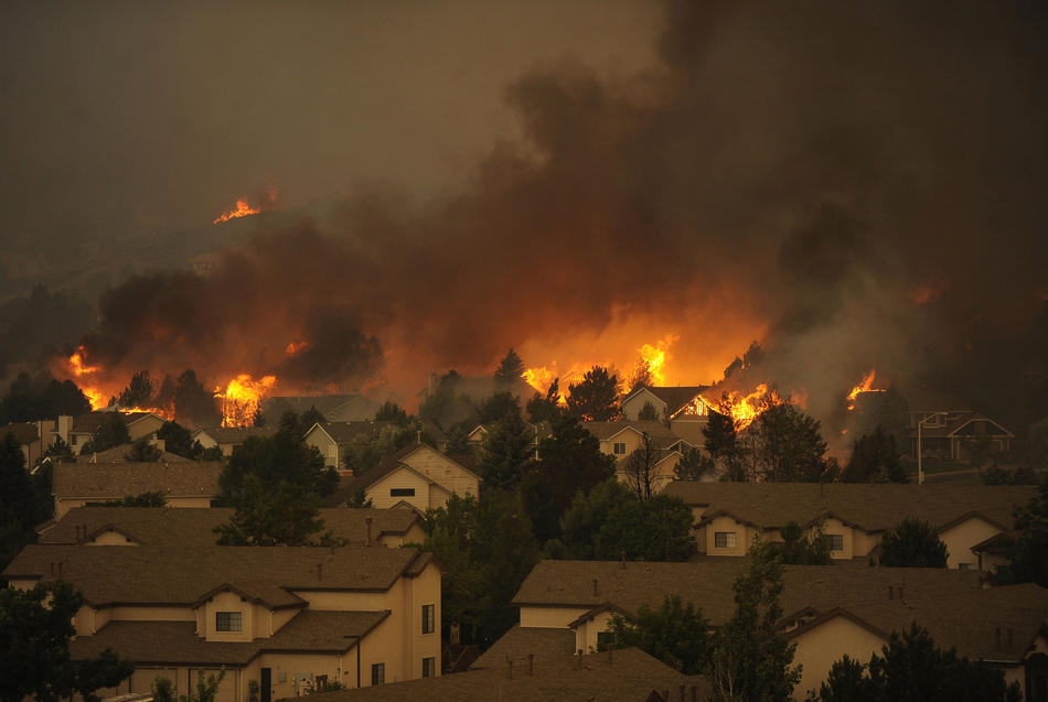
Iverson writes that a large area of contaminated topsoil was covered with more topsoil and pronounced safe.  Rocky Flats is aptly named, as millions of tons of glacial erosion products have covered the area with gravel.  The surface is called ground armor, mostly rock, as the high winds in the area have blown much of the finer material away.  That continues, and rodents burrowing bring buried soil to the surface where it blows into the Denver Metro area..  

The nearby Standley Lake, a large irrigation reservoir that provides water to Westminster and Broomfield, allows boating and water skiing but bans swimming because the lake bottom is contaminated with plutonium.  Many experts have advocated banning development in the area, but houses are going up. 

I got interested again recently because the NOAA National Weather Radar website is my go-to means of weather monitoring.  The TV weather people are either warning the apocalypse is imminent or it is fine, no rain, just before a major hailstorm.  Over a period of months I noticed a nearly constant radar image indicating precipitation over the NWR.  Day or night, weekends or weekdays, the image is there.  If it really is rain, the refuge would be a major swamp at the base of the Rocky Mountains.   

Many years ago I was a radar repairman in the Army.  One of the radars we maintained put out so much radio frequency energy it would kill birds flying in front.  We had quite a bit of training about ionizing radiation.  Radars emit radiation, so does decaying plutonium.  I could not come up with any explanation for the radar image other than radioactive decay.  This would be  disastrous, as much of the Denver metro area is downwind of Rocky Flats.   

I sent a number of emails to the NWS, TV stations, and the CDPHE.  I guess I stirred things up a bit, because I got a long, thoughtful letter from CDPHE outlining the investigation I generated.  The conclusion reached is that the radar image is from dust coming from a gravel mining and crushing operation just adjacent to the refuge.   Here is the letter:

Begin forwarded message:

From: “Spreng, Carl” <carl.spreng@state.co.us>
Date: July 13, 2016 at 3:56:58 PM MDT
To: levanks@me.com
Cc: Phillip Peterson – CDPHE <phillip.peterson@state.co.us>, Surovchak Scott <Scott.Surovchak@lm.doe.gov>, “Moritz, Vera” <Moritz.Vera@epa.gov>, Lindsay Masters – CDPHE <lindsay.masters@state.co.us>, Darr Bob <Bob.Darr@lm.doe.gov>, Rob Beierle – CDPHE <robert.beierle@state.co.us>, Smith Warren <warren.smith@state.co.us>
Subject: Rocky Flats

William Shanks

Mr. Shanks,

Your message sent to Phill Peterson in our Radiation Control Program was forwarded to me for response. I discussed your observations with a representative of NOAA. NOAA scientists apparently notice a fairly consistent dust cloud in the Rocky Flats area. This is consistent with the adjacent gravel operations — current and historic. You can observe the dust that rises off these operations as you drive by the site.
During remediation, the source areas of radiological risk in the Central Operable Unit (managed by the US Dept. of Energy) were excavated and shipped out of state. The human health risks inside the Central Operable Unit and the remainder of the site (managed as a refuge by the US Fish and Wildlife Service) were assessed following remediation and risks were found to be very low. A final decision for the site declared that any conceivable use would be appropriate in the Refuge area. That decision was based on an enormous amount of data (surface soil, subsurface soil, groundwater, surface water, air). After the remediation was completed, an aerial survey was conducted using a low-flying helicopter with detectors.
Offsite areas in the vicinity of Rocky Flats are also safe for any use. Numerous offsite surveys confirm the conclusion that only a few samples just east of Rocky Flats detected plutonium concentrations above background levels. You can read more information about the sampling on and around Rocky Flats on the Colorado Dept. of Public Health and Environment’s (CDPHE) web page at:  http://www.cdphe.state.co.us/hm/rf/index.htm.
 
Please contact us again if you have more questions.


Carl Spreng
P 303.692.3358  |  F 303.759.5355  |  C 303-328-7289
4300 Cherry Creek Drive S, Denver, CO  80246-1530
———- Forwarded message ———-
From: Carol Leavenworth <levanks@me.com>
Date: Tue, Jul 5, 2016 at 12:39 PM
Subject: Rocky Flats
To: phillip.peterson@state.co.us


Sir,
I notice there is a consistent radar image over the Rocky Flats NWR when viewing the NOAA national weather radar website.  I am no physicist, but ionizing radiation is detectable by radar.  Is this the case at Rocky Flats?  Is there a radiation hazard outside the closed zone?  Is there a public health risk for the nearby residential areas?I was a radar repairman in the Army in the 1960’s and remain interested in the field.  There weren’t many RF energy safeguards back then and there were nuclear weapons stored where I was stationed in Germany.
Thanks.
William Shanks
2032 S. Logan St.
Denver CO 80210
303-830-0599

After Cleanup

After Cleanup

I was skeptical, so I drove out there.  I made a couple of circuits around the area, passing through new subdivisions where grading was going on and decided that was not the source.  I then turned off SH 93, the road from Golden to Boulder into what used to be the west gate to the bomb plant.  I went past lots of no trespassing signs to a big gravel mining and crushing operation.  The crusher was producing a significant dust cloud.  There were lots of big gravel trucks, indicating a major operation.    

I left without getting stopped for trespassing and made another lap around the refuge.  The gravel operation is to the southwest of the refuge, and I could see the dust cloud from north of the refuge.  Mystery solved.  it is not ionizing radiation creating the radar image, it is dust.  

There is no radioactive cloud coming off Rocky Flats.  There is, however, still a lot of radioactive and chemical pollution out there.  I suggest you not buy one of the nice new houses being built in the area..  
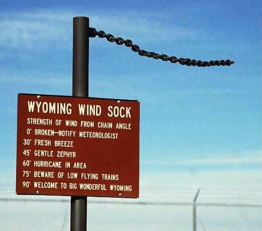
Dirty Denver

Windstorm

Windstorm

The wind blows here in Denver, and it is not all air.  Those mountains just west of us are wearing down.  Most of the sand and dirt ends up in the rivers, put the wind blows some of the mountains away.  If you park your car outside, you already know this.  The dust covers everything on the car, and you have to wash the damn thing.  Mostly the dust is that tan/brown dirt color, but sometimes it is red when parts of Utah decide to take a visit.

The constant deposition of wind-blown dirt is why ancient cities get buried.  The process is slow, but relentless.  Denver is being buried, but we haul a lot of it away.  Our older house has what seems to be sunken sidewalks.  It is the wind- blown dust combined with organic matter (grass clippings) to form topsoil.

Carol likes to say that a lot of the stuff that accumulates is spider legs.  True, along with the exoskeletons of millions of insects.  In geologic terms the rate of deposition of all that stuff is fairly rapid.

Here on Colorado’s Front Range we get wind, but nothing like the mountain winds, unless you live in Boulder or other places at the foot of the mountains.  The mountains are high enough to get some of the higher altitude winds that the flatlands don’t get much of.  Also, when a weather system blows in, the mountains act as a barrier, forcing all that moving air up.  As it rises, it cools, gets more dense, and descends on the lee side of the mountains. As it falls, it gains velocity and tends to warm up, creating our famous chinook winds.

Loess Soil Windblown Dirt

Loess Soil
Windblown Dirt

As the wind moves on the plains, it’s velocity decreases and some of the dirt it carries falls out.  Close to the mountains, a lot of it is sand.  That explains the sand hills we have close to the mountains.  You can identify the sand because it does not support plant growth as well as soil.  Sandy areas are cow country, no farming.  A little farther east, the dirt falls down.  A lot of dirt falls down, forming loess, a German term for wind-blown dirt deposits.  Eastern Colorado has thousands of square miles of loess.  Without irrigation, it is usually planted in wheat.

Of course, all the water or wind-borne sediment is headed for Mississippi, Lousiana, or the gulf.  Most of that Mississippi mud will end up as shale.  At some point plate tectonics will shove it up as dry land and the cycle starts over.  Most of the sand will eventually end up in the streams, get buried, and form sandstone like the Dakota sandstone dinosaur fossils are found in.  In other places, tremendous deposits of wind blown sand accumulate, eventually forming the sandstone that blankets the Colorado Plateau.

That dirt accumulating in your lawn and garden is part of a recycling process going on all over our planet for millions of years.  The process will continue long after we are all gone, as long as there is air and water on the planet.  To me, the whole thing is a miracle, all these geologic processes creating conditions existing long enough for the evolutionary mistake known as humanity to develop.