Category Archives: Earthquakes

Plate Tectonics

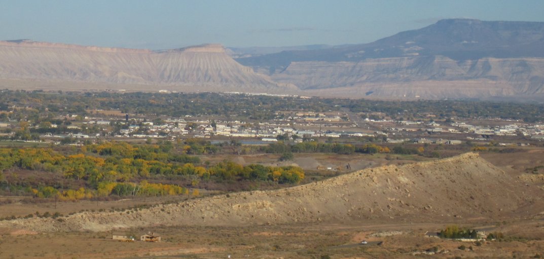
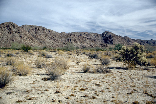
Western Colorado’s Grand Valley

As a Western Colorado Native, having lots of geology looking down on me sparked my interest in the field.  I have to know, so knowing how the Bookcliffs, Grand Mesa, and the Colorado National Monument got there stirred my curiosity.  Plate Tectonics is responsible for that stuff poking up all over the place.

Back in the Permian when I took geology at Mesa College, the orthodox explanation for mountain building was something called isostasy.  Push down in one place, and something will pop up nearby.  New Orleans and the Mississippi Delta is sinking under the weight of all that mud coming down the river.  New England is rising a little because that heavy glacial ice sheet melted.  Geologist tried to make isostasy work in places like California with little success.

The early twentieth century saw some new thinking.  Alfred Wegener proposed that continents move around on our sphere.  He was laughed at when he gave papers on the idea.  Yes, Africa and South America look like they once fit together, but how can an entire continent move?  That is a lot of mass to be sliding around.

In the nineteen sixties new thinking started to change attitudes.  Why are there identical fossils on the African and South American coasts?  The real game changer came when oceanic exploration found the mid-oceanic ridges with young basalt near the ridges and steadily getting older farther away.  The only explanation was a spreading seafloor.  Things are on the move.

After college I subscribed to Scientific American magazine.  It seemed like a new article appeared every month explaining how physical features are the result of magma (molten or hot and plastic rock) on the move.  There are seven big (North America, Asia) plates and a number of smaller ones being affected by the rock coming from that spreading seafloor.
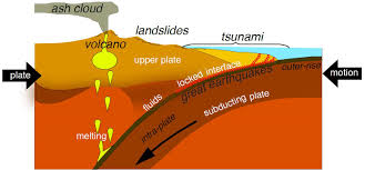
Subduction

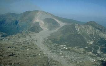
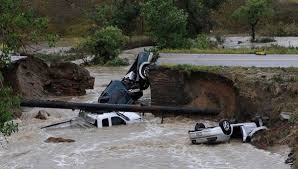
As the oceanic sea floor impacts the boundary of a continent, something has to give.  The more dense seafloor basalt tends to dive under the continent.  They can form trenches almost seven miles deep next to a subduction zone where the plate dives under the lighter rock of a continent.  The subducting rock is wet, and changes chemically forming lighter rock that often belches up as volcanos.  Earthquakes occur as the plates bump against one another, dip, or slide.

The island arcs off Asia are the current example.  Java, the Philippines, Japan, New Guinea are all volcanic islands getting ready to smash into Asia.  India already has, creating the Himalayas at the suture.  Lots of shaking there, too.

Around 1.75 billion years an island arc docked (yes, geologists use that word) on the Wyoming Craton.  The craton has some rocks as old as six billion (abbreviated as 6 ga) years old.  Many of the rocks are around 3 ga.  The oldest Colorado rocks are around 1.75 ga.  Just outside Morrison, Colorado is the Great Unconformity.  The red rocks are about 60 ma (million years).  The dark gneiss and schist just barely up Bear Creek canyon are those 1.75 ga guys.  Lots went on between those dates, but there it is all eroded away.

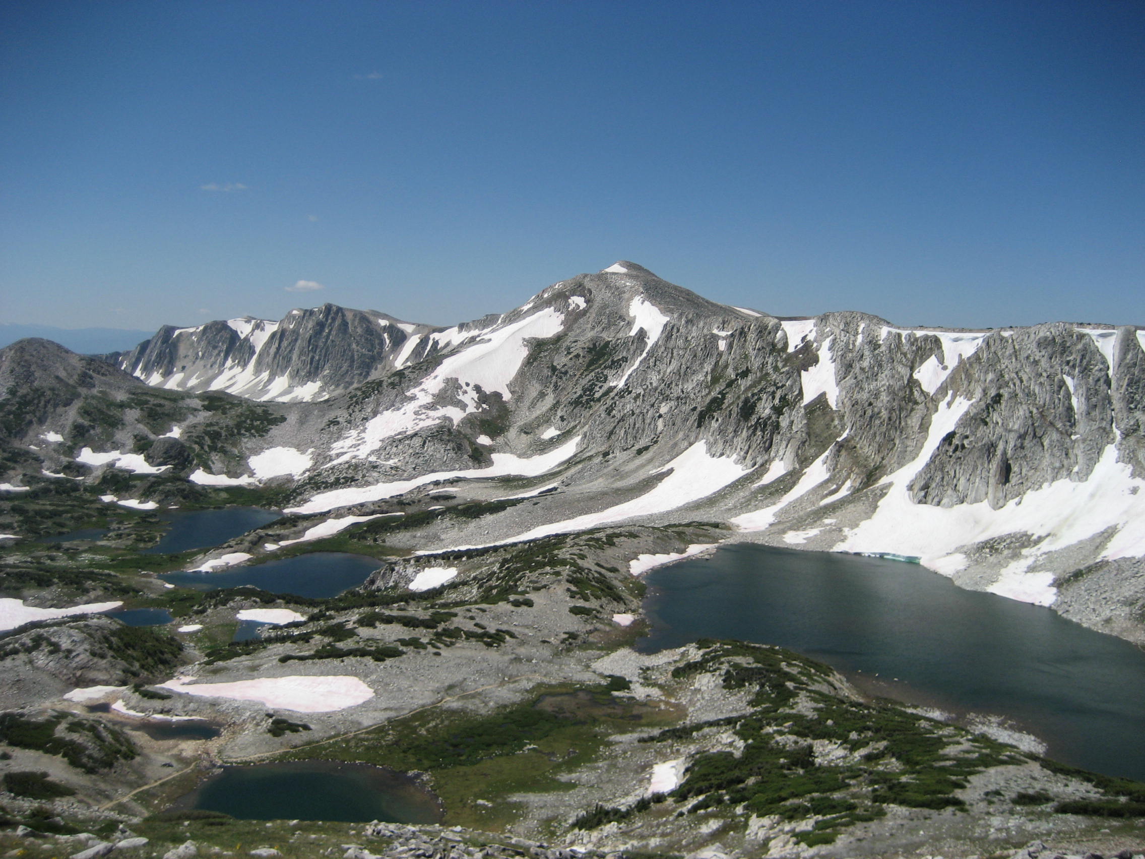
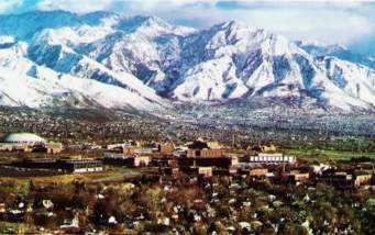
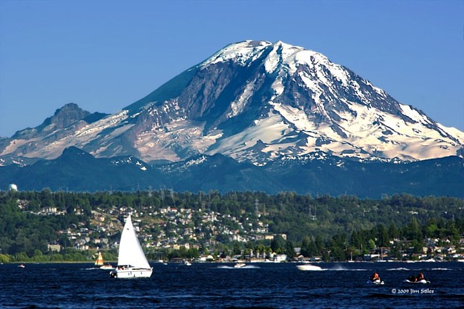
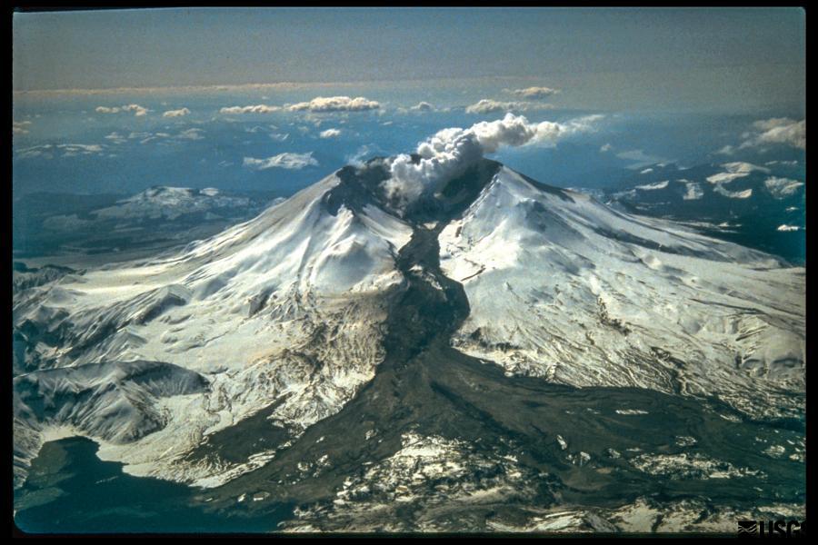
Snowy Range, formed by Colorado smashing into Wyoming

The Snowy Range in Wyoming is a result of the join-up.  The coastal ranges in California that like to shake and burn and belch fire and rock formed from the collision of the Pacific and North American plates.  As you are probably aware, L.A. is headed for Anchorage.  Don’t worry it’s going to take a while.

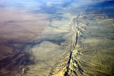
The Rocky Mountains are kind of a strange story.  Usually mountain building occurs at plate boundaries, like the Andes and the Cascades.  What is known as the Laramide Orogeny that created the Rockies happened about 800 miles inland.  The idea is that for some reason about 80 ma the pacific plate scooted under the lighter continental rocks before diving. The Rockies came up a bunch, the Colorado Plateau, my homeland, not so much.

The Rockies are now sitting still but the plateau is moving clockwise, pulled by the pacific plate sliding north against and under the north american plate at the continental boundary, as things should happen.  The Basin and Range province, Nevada mostly, is being pulled apart.  For some reason the Colorado Plateau wants to stay in one piece while western Utah, Arizona, and Nevada are coming apart.

All this motion is happening at about the rate your fingernails are growing.  It doesn’t seem like much, but after a few million years we are talking big moves.  Stay tuned.

My favorite book on these topics is Annals of the Former World, by John McPhee.  It is a big book composed of sections covering the territories along I-80.  Great reading.

Terremoto

I was sitting in a building in the San Jose, Costa Rica airport waiting for my luggage when the building shook.  A soccer game was on the TV, and the guys just looked up and grinned at one another.  It wasn’t much of an earthquake, but Costa Rica has had some big ones.  It’s a mountainous country, and in 1991 a big one closed the road and railroad from San Jose to the Caribbean coast for weeks.

Typically, earthquakes happen where tectonic plates collide.  In Costa Rica it is the Cocos Plate diving (subducting) under the Caribbean Plate.  The  Cocos is headed east, the Caribbean is moving west.  The combined motion makes for some real fireworks.  The boundary is marked by a string of Volcanos.  The only active volcano I have visited is Irazu, northeast of San Jose.  It is a big tourist attraction and showered ash on President Kennedy in March of 1963.  I developed more of an appreciation of a volcano’s power when I looked into the crater.

Volcanos and earthquakes release energy on a scale that overwhelms the human imagination.  The nation of Japan moved about eight feet east feet during the 2011 earthquake which caused the tsunami responsible for inundating the east coast of the island.  Sea level rose about ten feet.  Now that, folks, is one hell of a shove.

Economic loss was in the neighborhood of $235 billion, the costliest natural disaster ever.  The magnitude was 9.1, about as big as they get.  Remember the scale is logarithmic, with the amplitude increasing by a factor of ten when moving from number to another.  Thus a magnitude increase from four to to nine is 500 times more intense.  The energy release is not on the order of ten times, but closer to thirty times.  You do the math.  It is enough energy to change the rotational speed and tilt of the earth.

The southern end of our old friend the San Andreas fault is overdue for a major slip.  The northern portion is less likely as several good sized quakes have released much of the stored energy.    Estimates of the magnitude of a big one on the southern segment are in the range of 8.0.   Not as bad as the Japan shake, but enough to more than $200 billion, with major loss of life.  That Los Angeles Basin is full of people and stuff.  A big quake would trap most of the people there with no power or water.  Can you imagine no superhero movies for many months?

Christmas brought me several good books, including one on earthquakes and one on wildfire.  Brace yourself for disaster stories.  What is clear to me from my studies on wildfire and earthquakes is that there is risk to living on this planet.  Humanity only serves to magnify the rise.   We want our surroundings to be fairly steady state.  Not so, the driving force is change.  Whether natural phenomena or human caused. It will all change and then we die.  The key is to make life worthwhile, accepting the inevitability of change.  In the meantime, try to avoid Southern California if you can.

There’s Hurricanes in Florida and Texas Had Rain

Colorado Desert

I am a child of the desert, and the guy sitting next to me in the coffee shop is from Saudi Arabia.  Those of us from dry country usually don’t understand why people would choose to live in wet, low country with hurricanes.  Yes, there is the ocean, but we can always go to Lake Powell or Lake McCounaughy.  We do have a few tornados and hailstorms, and one of the canyons floods every 15 years or so.

On the gulf or Florida coast they get a hurricane at roughly the same intervals, but the damage is widespread and many more people are affected.  For some reason, most of the people in the world live close to a seacoast.  Yes, trade is easier and things tend to grow there (not like our Great American Desert).

Too low, too many people, too wet.  And yes, the oceans are headed inland.  It will be even wetter.   It is somewhat harder to make a living here in mid-continent and the seasons can be more harsh, but grand catastrophes are rarer.  I must confess a warm ocean is good for visits, but I did not like the mid-Atlantic, but maybe it was because I was on a troopship.

Another problem with seacoasts is many of them have a tendency to shake.  The tectonic plates collide on the coasts, thus mountains and earthquakes.  I prefer the ground under me to hold still.  When we visited Carol’s daughter in Menlo Park CA, I was a bit nervous being halfway between the San Andreas and Hayward faults in a flood plain.  The real irony is that the U.S. Geological Survey regional office is there.

Japan Earthquake and Tsunami

Here in Denver, there were big earthquakes once when the Rockies were rising, but it has been a while.  We had a flurry of small ones when they were pumping hazardous waste down a drill hole at the Rocky Mountain Arsenal.  When they stopped pumping, the earthquakes stopped.  That lesson was ignored in the Oklahoma oil fields where they pump fracking water back down drill holes instead of treating it.  Most of the state is shaking.

“Do it cheaply, don’t bother with doing what is right.”  It seems to be standard procedure in the extractive industries such as oil and gas and mining.  The solution is regulation, but the oil business owns the government in Oklahoma and Texas.  They are close to owning the U. S. Government.

I seem to have drifted into a rant.  Weren’t we discussing living on the coast?  The coasts stand to reason from a short term economic standpoint.  The rivers are there, shipping is cheap, it is fairly flat, and the climate tends to be moderated by the ocean.  Except when it is not.  Hurricanes, nor’easters, increasingly wetter monsoons, and sea level rise is scary.

Tidal Flood in Florida

How would you like having sea water pouring out of the storm drains in your street at high tide?  What about having your crops inundated by incessant rain?  Do you want the roof ripped off your house and be without power for many days?  Then there are tsunamis.  Take a look at the Japan tsunami on YouTube.  If none of this stuff bothers you, live on the coast.

Where Not To Live

Living in Colorado, I may be arrogant about all the inferior places in the country, but the ones on this list are unsafe.  They are also popular.  It seems people like to live on the edge.

San Andreas Fault

At the top of my list is anywhere near the San Andreas Fault.  When two tectonic plates are bumping along one another, things get shaky.  Just look at those aerial photos of the gouges the  sliding plates created.  Lots of energy goes into motion of that magnitude, and there is plenty left over to bring buildings down.  The  Los Angeles and  San Francisco areas have a lot to offer.  Climate, scenery, the Pacific, and all those geologic features created by the colliding plates.

The place of greatest folly is the Portola Valley.

Fault in Portola Valley After 1906 Earthquake

Just west of Stanford University, the valley is not a stream valley, it’s a fault valley.  The valley is full of big houses located not near the fault, but on it.  Well, not right on the fault, you must build fifty feet away from the fault.  Portola Valley is one of the richest zip codes in the country which is a good thing; the people will have the money to rebuild somewhere else.  There is a strict building code, but the fault is just too damn close.

A relative used to live in Menlo Park, one of the charming and wealthy communities in Silicon Valley.  Her house was midway between the San Andreas and Hayward faults in a flood plain. What are those people thinking?  Pretty country, though.  She had redwood trees in her front yard.  One of my favorite ironies is that the west coast office of The United States Geological Survey is in Menlo Park.  What were they thinking?

Shaking in Parkfield, Oakland, San Francisco, Northfield, Palmdale, and soon.  The entire Los Angeles area is at risk.  There hasn’t been a big quake in some years.that means increasing amounts of energy is being stored along the fault.  It’s not if, but when.

Mt. Rainier

Those tectonic plates are at it it the Pacific Northwest as well.  There are earthquakes there, but the real danger is those pesky volcanos.  All those striking photographs of Seattle nestled beneath Mt Rainier?   It is an active volcano, folks.  It has been a while, but every day is one day closer to the next one.  Mt. Hood is due as well.  Are you old enough to remember Mt. St. Helens?  1980.  Not many lives were lost, it is in a remote area, but the blast flattened the forest for miles.

The real danger from those big volcanos is pyroclastic flows and lahars.  The eruption releases massive amounts of ash and larger chunks (clasts).  In addition, parts of the mountain blow apart, and the whole mess heads downhill.  It is hot, coming out of the volcano, and wet from the ice and snow on the mountain. There are huge landslides contributing to the mass, which can travel as fast as 300 mph.  Everything in the flow’s path is buried or carried with the flow.  What is scary is that Seattle, Tacoma, Eugene, and other towns are in the path of the flows.

Track of the Lahar after Mt. St. Helens eruption.

In an earthquake, buildings collapse and maybe burn.  A pyroclastic flow kills everything in its path.  If the heat doesn’t do it, the ash in the air is so dense it fills the nostrils of any animal.  It also buries land with upwards of several feet of ash.  Lahars travel down valleys and is a mass of ash, rock, water, and any other thing in its path.  It flows down the valley and when it stops, it is the consistency of concrete. No living thing survives.  Stay away.  The Puyallup Valley is most vulnerable from a Rainier eruption.

Don’t live right on the coast either.  Earthquakes can generate tsunamis that will sweep away anything in their paths, sometimes far inland.  In addition, sea level rise will drown lots of development.

Salt Lake and the Wasatch Mountains. Fault at base of mountains

Moving east, the Salt Lake mountain front is overdue for a big earthquake.  The city developed at the base of the Wasatch Mountains, with a huge fault at their base that moves fairly regularly.  Watch out, people, Zion is going to shake.

Another place to avoid is Florida.  A beautiful place with amazing wildlife, the peninsula is just a slow moving disaster punctuated by somewhat lesser disasters.  The biggest problem, it is all limestone.  Not just limestone but limestone honeycombed with water filled voids.  The voids are growing as the abundant rainfall soaks in and dissolves even more limestone.  Sinkholes are the result.  There are more all the time.  In addition, Florida is low and flat.  Low enough for much of it to go under as seal level rises.  It’s happening.  Every flood tide, water flows out of manholes in subdivisions north of Miami.  The rise will continue, and Mr. Trump isn’t helping.

Charlotte Harbor

Oh, and there are the hurricanes.  They sure do make a lot of messes.  Climate change is predicted to increase the number and intensity of the storms.  My late in-laws lived for a time in one of those retirement trailer parks on Charlotte Harbor, on the Gulf coast.  The trailer  park is gone, thanks to Hurricane Charley in 2004.  My in-laws had moved to Mt. Dora before the hurricane.  Mt. Dora is in the middle of the state on high ground (around 300 feet).  They have had 77 hurricanes since 1930.  One of the storms knocked out power for two weeks.

The only time I have had real reason for fear while in an airplane was when we flew into Orlando during a thunderstorm.  We were on approach when I saw the storm hit us.  The visibility went to zero and turbulence rocked the plane.  The pilot shoved the throttles forward and went around.  By the time we circled around, the storm had moved on.

The entire East Coast is also hurricane country.  The ocean also seems to want to move inland.  Don’t be in the way.  The ocean is rising.  The coast is moving west.

New Orleans After Katrina

The Gulf Coast is also a danger zone.  Subject to hurricanes, low lying areas can also be flooded by rising rivers.  The Mississippi Delta is also no place to live.  It is sinking.  The Mississippi River mud is going over the continental shelf, thanks to the Corps of Engineers channeling the river straight to the gulf rather than allowing it to build the delta.  The river is going to win.  It will not allow itself to be contained for long.  Louisiana, beware.

Go up the river to New Madrid, Missouri south of Memphis.  Earthquake country.  The last time it shook, bells rang in Boston.  That was in 1812, when the population in the quake region was small.  It is small no more.  St. Louis is vulnerable.

Tornado

Now that we are in the Midwest, let’s discuss tornadoes.  The entire region is at risk, with devastating storms anywhere.  Tornado Alley, from Texas through Oklahoma and to Kansas, Missouri, South Dakota, and Iowa has the most danger, but anywhere east of the Rockies has some risk.

The general idea here is that nowhere is completely safe, nature being what it is, but there are some areas that I would not live in.  I think I will stay in Colorado away from those canyons that like to flood.  Oh, wait, if Yellowstone lets loose, we’re toast.

Shaking and Baking

As you are aware if you are a regular reader of my ravings, I am a geology buff.  I like the Big Picture, mid-ocean rifts and rises, tectonic plates shoving one another around, places where the hot insides spout out of the ground, mountains rising and being worn away, and the oceans becoming ever more salty.  Most of the time, all this is a slow process, but sometimes all hell breaks loose.   

San Andreas Fault

San Andreas Fault

Just look at that photo of the San Andreas Fault.  Things are clearly on the move and the land is being torn apart.  The Pacific Plate is sliding northward along the North American Plate.  Pasadena will one day be next to Anchorage.  Don’t wait up for it, though.  The Pacific coast of North America is one of the most seismically active regions on the Ring of Fire surrounding the Pacific Ocean.  It shakes, it blows, it smokes, it flows.   

Places like that make nice places to live.  Most of the time.  There is the ocean, lots of pretty landscapes with beautiful mountains nearby,  and places to grow things.  Just look at the Seattle-Tacoma area.  Bays, inlets, rivers, islands, and a big old mountain to look at.  It is easy to forget that mountain is a large volcano just biding it’s time until it lets loose again.  

Mount Rainier. Close to Town

Mount Rainier. Close to Town

If Rainier resembles Mt. St. Helens in the way it erupts, there might be some warning.  What we won’t know is how big, exactly when, and for how long.  There is a lot going on in that area.  Boeing, Microsoft, REI, millions of people, and Starbucks are a few examples.  If a swarm of magnitude four earthquakes begin, what to do?  Shut everything down and evacuate?  Where will everyone go?  What about looting and plundering?  What if it doesn’t erupt for months, if ever?   

Pyroclastic flows of very hot, wet, chunky stuff have flowed off that mountain all the way to the ocean.  The old cliche says “It is not if, but when.”  We just do not know when.  So, life along the Pacific Rim is always something of a gamble.  I have felt small earthquakes and looked into the crater of a Volcano in Costa Rica, a lovely, green, paradise.  Earthquakes destroy roads and railroads, volcanos bury villages, and life goes on.   

Irazu, Costa Rica

Irazu, Costa Rica

Small, poor Costa Rica is one thing, the Seattle-Tacoma area, or Los Angeles, or Portland, or Eugene, or San Francisco are entirely different matters.  No amount of preparation can take into account all the things which might happen.  Prediction is in its infancy.  Mt. St. Helens in hindsight gave lots of warning, but the disaster was huge in a relatively isolated area.  When Rainier or Mt. Hood let go the disaster will be in a heavily populated area with just a few ways out. 

Currently there are lots of earthquakes in the oil field regions of Texas, Oklahoma, and surrounding areas.  I wouldn’t worry too much if I lived there, the odds of a Big One are fairly small.  St. Louis and Salt Lake are at more risk.  The West Coast is the big danger zone.  The earth will keep moving, the plates will continue to slide.  Eruptions and quakes will continue to happen.  My solution?  Don’t live there.  What is your plan?

Weather

Climate Change

Climate Change

2013 Flood

There is currently a lot of controversy about climate change and whether humankind has a role in the warming trend.  While I think it is true that pouring huge amounts of sequestered carbon is the culprit, I don’t think it matters much for us here in Colorado and much of the west. 

We live in a land of extremes except for the rainy Pacific Northwest, but, they have their earthquakes and volcanos.  Here in Colorado, we dwell in a land of extremes.  The west is dry, it snows in the mountains, the Front Range is kind of a mix, and it is pretty dry in the east.  That varies from year to year.  It varies a lot.   

In the late nineteenth century it was a wet cycle in the eastern prairie, and the railroads made millions enticing settlers to buy their land and get rich farming.  The population in eastern Colorado peaked then and has been declining ever since.  The mountain ski areas have lots of snow some years and almost no snow other years.  The western desert country looks dry and desolate most of the time, but I have seen it bloom in a stunning variety of color.   

Then there are the floods, blizzards, and tornados, often followed by drought.  The one thing we can count on is change.  There are long term trends.  Most archeologists think one reason the ancestral Pueblo Indians left southwestern Colorado was a prolonged drought cycle.  Anyone who tries to raise dry land beans in that country can tell you not much has changed. 

2013 Flood

2013 Flood

Here along the base of the mountains we have the extremes as well. There was the drought of 2002, and the floods of 2013.  The mountains create an unusual weather pattern that stalls along the mountain front, bringing more moisture than the land can handle.  That is when lots of the mountains wash out into the flat country.  It has been going on for more than sixty million years.  The gravel in the Platte River in Nebraska is Rocky Mountain gravel.  Some of the Louisiana mud is Long’s peak mud.   

Some climate models say climate change is going to dry Colorado out, other models say it will be wetter.  My money is on more extreme weather.  Longer, more violent wet periods and long droughts.  Look for more frequent floods, not the thirty or forty year cycle we have had since the first European-American settlers and miners arrived.  Think about the tornados and hailstorms recently.   

I like the extremes.  We have our regular four seasons here but the winters are milder than in Iowa.  It can get hot but there are few days over one hundred degrees, but not like southeastern Utah.  I think that may change, hotter in the summer.  I don’t think the winters will be colder.  I can remember forty below in Boulder when I was flunking out of CU.  Twenty below seems to be more the cold winter norm now.  What I do not like is the hailstorms.  I don’t think the insurance companies like them much either.  Homeowners insurance costs keep rising.  That hail is hard on the garden as well. We had only one tomato plant survive last year. 

One of the big impacts of climate change will be on water supplies.  The amount of precipitation may not change, but if it is warmer, the snowpacks will not last as long in the spring.  That means more spring floods and a shorter runoff period, which will impact water storage.  That could be bad news for the populated Front Range.  People keep coming, but there will not be more water, and a lot of the big spring runoff will go out of the state.  That will be good for the Sandhill Cranes in Nebraska, but bad for Parker and Highlands ranch. 

I spent a long time in the water business, and it always disturbed me watching all that high quality drinking water being used to attempt to replicate Surrey or Connecticut foliage in the Great American Desert.   All that bluegrass will have to go. The urban forest will have more drought-hardy trees.  Denver Water’s customers have done a good job of conserving since the big drought of 2002, but the bluegrass model of landscaping continues.  In Denver, daily water consumption is about 110 million gallons per day in winter.  I the hot part of summer, it’s over 400 million gallons per day, most of it run out onto the ground. 

At our house, we have significantly reduced the size of our lawn, but we still have a lot of crabgrass.  It should be buffalo grass and blue grama, both native drought-resistant grasses.  They don’t stay green all summer, so we are stalling and paying the water bill.  Marijuana legalization is bringing lots of people to Colorado, and the economy is booming.  Those people use water, and lots of water is used growing the stuff.  One of the unintended consequences of legalizing pot is increased water consumption. 

Myself, I am not too concerned about climate change for myself.  After all I am 73 years old and don’t live on the coast.  Long term change is a reality, but as John Maynard Keynes said, “In the long range we are all dead”.


Our Little Planet

Mt. St. Helens showing a Lahar, a mud and ash flow that ran 50 miles downstream during the eruption.

Mt. St. Helens showing a Lahar, a mud and ash flow that ran 50 miles downstream during the eruption.

Stephen Hawking says we need to have to develop means to get off the planet when the Big One, whatever it is, is about to strike.  That is not terribly realistic, relocating several billion people to a place light-years away.  In other words, life on earth is toast.  Someday.In the meantime, life goes on.  It is spooky how we are fouling the planet.  We humans may create the need to get off this little ball without the means to do so.  In other words, life on earth is toast.  Sometime, maybe sooner.So, let’s deal with what we have while we can.  There are things we can do, but the means to act are part of a political process.  As long as politics is motivated by greed at the level it is currently, we are likely toast.  Maybe sooner.

The cliff that collapsed into a massive mudslide is seen covered with felled trees in Oso, Washington March 31, 2014. Recovery teams struggling through thick mud up to their armpits and heavy downpours at the site of the devastating landslide in Washington state are facing yet another challenge - an unseen and potentially dangerous stew of toxic contaminants. REUTERS/Rick Wilking (UNITED STATES - Tags: DISASTER ENVIRONMENT) - RTR3JE4A

The cliff that collapsed into a massive mudslide is seen covered with felled trees in Oso, Washington March 31, 2014. Recovery teams struggling through thick mud up to their armpits and heavy downpours at the site of the devastating landslide in Washington state are facing yet another challenge – an unseen and potentially dangerous stew of toxic contaminants. REUTERS/Rick Wilking (UNITED STATES – Tags: DISASTER ENVIRONMENT) – RTR3JE4A

As individuals, we must do what we can, and get along with our lives.  We can help, and maybe stave off the inevitable to some degree.  We can respond to natural events.  Floods, earthquakes, tornados, landslides, hurricanes, those things we can react to and help.  We must do more than sit in the Lazy-Boy looking at the screen eating Doritos.  We can give money away, stir things up in meetings, vote, and give some time.

Well, we can do things until Yellowstone blows.  It is surprising how resilient humans are.  Ice ages, cataclysms, droughts, they may kill some and move others around, but the species has struggled on through it all.  We haven’t been around very long, however, and haven’t had to deal with any Really Big Ones in the blink of time we have been around.

The Yellowstone Caldera

The Yellowstone Caldera

The Park Service says the Yellowstone super-volcano is pretty safe, that most eruptions are limited lava flows.  But, someday, it will be like the last big one that created a caldera almost as large as the park.  The Snake River Plain in Idaho with all those lava flows is the track of the Yellowstone hot spot as the North American Plate traveled west.  The plate moves at about the rate your fingernails grow.  As it moves, it erupts.  It just takes a while.

Hurricanes, tornadoes, floods, drought, all interest me, but I am most interested in geologic cataclysm.  One of my favorite potential geologic disasters is climate-related.  Years ago I read an article proposing that sea level rise could lead to the Gulf Stream moving over the continental shelf and invading the Arctic Ocean.  Europe would cool off with the loss of that warm water and the Arctic Ocean would thaw.  With all that open water in the north, evaporation would increase, snowfall would increase in the Arctic, precipitating a new ice age.

I haven’t seen much on that hypothesis lately.  Researchers seem to be concentrating on the rapid melting going on without Gulf Stream migrations, although the Gulf Stream does seem to be weakening.  There are just so many variables to consider.

Ash From a Yellowstone Eruption

Ash From a Yellowstone Eruption

With respect to the Yellowstone super volcano exploding and killing most life in North America, there is only one variable: when.  A couple of years ago I was on a ramble in Wyoming.  Fort Laramie was my destination, but on the way I looked for the Oregon-California trail wagon ruts along the Platte outside Guernsey.  The ruts are dramatic, going up from the river bottom to some higher ground.  They are axle-deep in some tan colored rock that looks like sandstone at first glance.  It is volcanic tuff from the last time Yellowstone blew.  The layer is four or five feet deep about 200 miles from Yellowstone.  That is a lot of stuff blown into the atmosphere.  All that material along with the CO2 and SO2 would kill most everything for many hundreds of miles.

The most recent volcanic eruption in Colorado was about 4500 years ago at Dotsero.  The entire San Juan mountain range is volcanic.  Huerfano Butte near Walsenberg is a volcanic neck.  There are eroded lava flows on Trail Ridge Road in Rocky Mountain National Park.  There are lots of hot springs in Colorado.  Where is all that heat coming from?  Will the Glenwood Hot Springs Pool erupt?  Will Steamboat Springs’ boiler explode?

Landslides.  There is even one not far from Fruita on I-70.  Debeque canyon on the Colorado River is famous landslide country.  That landslide that killed three men outside Collbran last year is the same geologically.  Green Mountain in Lakewood has a landslide that destroyed several houses.  The Vail/Eagle River valley is good landslide country.  All it takes is a lot of moisture in spring. The canyons incising the front range are landslide prone.  All that rock will eventually find its way to Louisiana as mud.

The upside of all that landslide country is that it gives geologists and earthmoving contractors work.

There is a radioactive isotope of radon gas that is common in some of our Colorado rocks that houses are built on.  Basements become carcinogenic.  There is an anthropomorphic cause of radioactive basements as well.  In Grand Junction, uranium mill tailings were used as backfill around basements is some subdivisions.  More work for geologists, and a Superfund site.

Debris is strewn over an area affected by an earthquake and tsunami in Miyako, Iwate Prefecture, March 14, 2011. REUTERS/Aly Song (JAPAN - Tags: DISASTER ENVIRONMENT)

Debris is strewn over an area affected by an earthquake and tsunami in Miyako, Iwate Prefecture, March 14, 2011. REUTERS/Aly Song (JAPAN – Tags: DISASTER ENVIRONMENT)

Earthquakes.  Again two causes, natural and human-caused.  All those earthquakes in Texas and Oklahoma caused by injecting fracking water back underground have a Colorado history.  Rocky Mountain Arsenal outside Denver was used to manufacture poison gas for military use and later poison gas for agriculture.  They pumped a lot of the toxic wastewater down wells and set off earthquakes.  They stopped that.  The oil companies are not stopping.  Yet.

Colorado is earthquake country.  Making mountains, shoving rock around to make room for more rock shakes things up.  The Flatirons outside Boulder used to be flat.  North and South Table mountains are capped with basalt from lava flows.  These processes are still going on in lots of places.

The Rio Grande Rift is a Rift Valley stretching from Southern New Mexico to north of Leadville.  The earth is pulling apart.  Look at the San Luis valley, that is a lot of pulling.  It is still going on, but slowly in human terms.  There will be earthquakes.  The biggest quake-causing fault near Denver is the Golden Fault, formed when the Rockies were uplifted.  That uplift has happened about three times.  The mountains come up, get eroded down, come up again, get eroded again.  Will it happen again?  There seems to be some weakness in the crust around here.

What the Meteor Looked Like Impacting off Yucutan

What the Meteor Looked Like Impacting off Yucutan

There are asteroids out there that have orbits that coincide with the earth’s orbit.  It has happened before, could again.  I saw Charlie Rose interviewing Neil DeGrasse Tyson, and he mentioned the possibility.  We have the technology to deal with the the threat, but it will take a lot of money and cooperation.  Will it happen before we need it?  Will it be too late when the danger is imminent?  Ask a Republican.  I hope you sleep well tonight.