Category Archives: Environment

The Urban Oil Field

Oil and Gas Wells in Part of Weld County

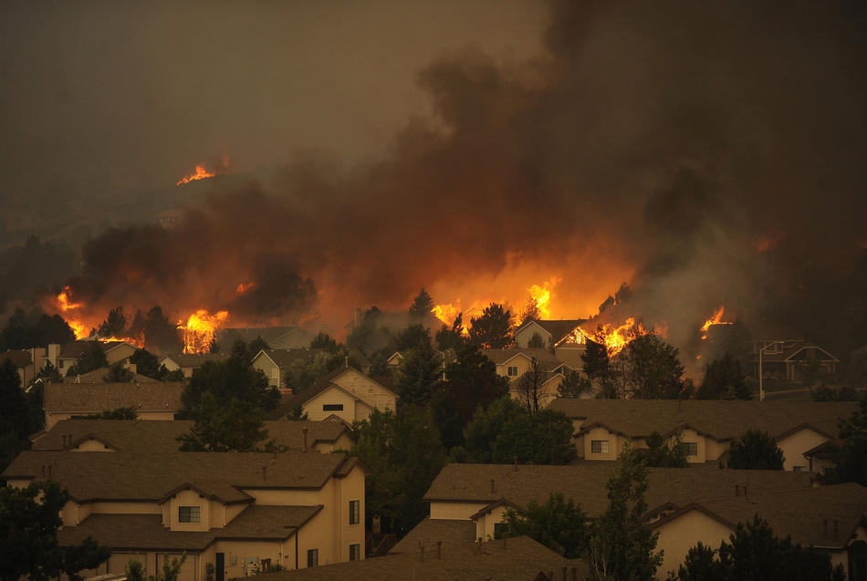
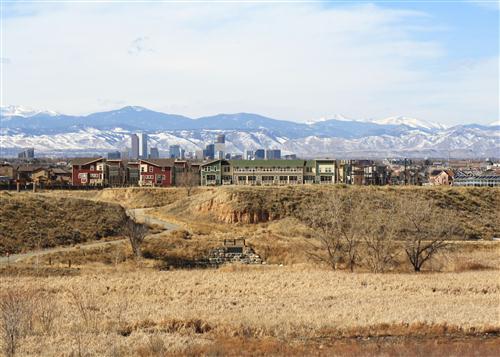
Weld County, Colorado is one of the richest agricultural counties in the nation.  It is also rich in oil and gas, leading to hundreds of wells extracting petroleum.  With all that money around, Northern Colorado is booming, with people moving and subdivisions being built on what was farmland.  The houses and wells are often neighbors, close neighbors.  As oil companies put profit ahead of proper well management, disasters ensue.  Colorado has lots of fires in the urban-wild land interface.  In Weld County it is the urban-oil field interface.

Colorado is home to 48,000 active wells and 52,000 abandoned wells.  All of them are potential  fire and explosion hazards, and can release methane into the atmosphere.  Think about that when your furnace comes on in the morning before you head out to your car.  We need renewal energy.

The Denver Basin is a huge geologic feature extending along the eastern front of the Rocky Mountains.  As the Rockies were uplifted, the Denver Basin subsided while filling with debris washing out of the mountains.  There is a 22,000 feet difference between the bottom of the Basin and the summits of the mountains.  That is a lot of gravel.

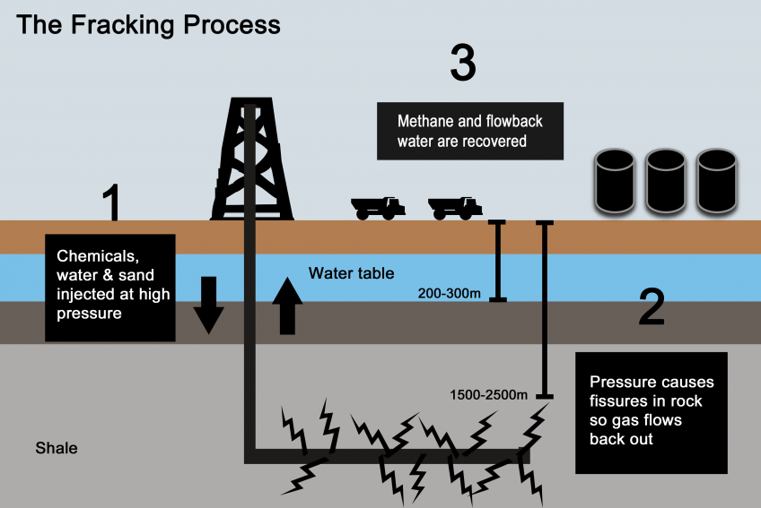
When there is a lot of structure in geologic formations, there is opportunity for oil and gas to migrate into the rocks.  The Denver Basin is one of the largest gas fields in the United States.  Oil and gas extraction started in 1901 in Boulder County.   Trillions of cubic feet of gas and millions of gallons of oil have come out of the ground since then.  Most of the production has come from sandstone or fractured shale.  The development of horizontal drilling and fracking has accelerated the process.  In Weld County, sites with as many as five wellheads and the installations to process the gas are next to residential areas.
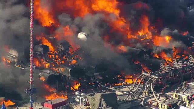
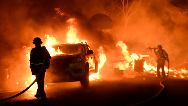
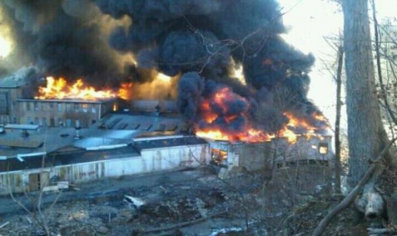
Oil Fire Near Homes

The result is spectacular explosions and fires near where people live.  Local fire departments, once used to fighting grass and barn fires, have sprayed thousands of gallons of firefighting foam on the fires and spent days on the fire scenes.  Attempts to increase regulation of the industry mostly fail due to the political clout of the oil and gas industry.  The politics may change with the election of Democrats to most of the state offices.

Keep in mind the oil bonanza is a major source of Colorado’s economy and growth.  The move to renewables is also a source of revenue to the region, but there will be inevitable disruption during the transition.  The oil and gas industry seems to be focused on keeping the wells flowing, regardless of the environmental consequences.  They do not seem to be shifting into renewals themselves, which may be a death knell.  Market forces will probably prove to accelerate the shift to renewables.  They are much cheaper than dragging fossil fuels out of the ground and pouring tremendous amounts of carbon into the atmosphere.  The remains of dinosaurs and ancient swamps need to stay in the ground.

Notes on Climate Change

Everyone who thinks is aware of the impact climate change on our weather.  Drought in some places, more violent storms, and water coming out of manholes in South Florida.  Drought may be a cause of the instability in the Middle East.  People forced off the land move to the cities, always hotbeds of turmoil. The west coast of central America has also had a drought resulting in crop failures, with many coffee trees dying.  The people displaced move to the barrios in the cities.  California has had its cycle of wet years followed by drought, fires, and flooding when the rain returns.  The cycle is mostly intact, but extended drought followed by huge fires seems to intensify the cycle.  The rains, when they come, are stronger, with big debris flows devastating large areas.

We are in the anthropocene, a time of massive human impact on the earth.  Climate change is a result of dragging hydrocarbons out of the ground, burning them, and returning carbon dioxide once sequestered to the atmosphere.  Atmospheric CO2 traps heat, warming the oceans.  Warmer water holds less oxygen, meaning many sea creatures are killed.

Permian Temperatures

The Permian Extinction was about 252 million years ago.  A major cause was a huge increase in CO2 due to a number of factors, mainly extensive lava flows in Siberia releasing CO2.  Lots of sea life died, but the land got greener and wetter, again sequestering CO2 as coal and petroleum.  There are other factors to the extinction, but the result was 98% of sea life dying, with more than 70% of land life.  It took about 10 million years for life to recover.

We are not going to see a die-off of that magnitude anytime soon, but the climatological and geological records illustrate the risks.  The science is clear, and science offers the remedies, but taking action is a political matter.  Here is where an old adage comes in to play.  “Money Makes the World Go ‘Round.”  Lots of businesses are making money producing and burning hydrocarbons.  Those businesses strongly influence political decision making.  Our Current Leader is mainly motivated by money, so you do the math.

It is getting bad, folks.  It looks like it is going to get worse.  I Hope reason and sanity will prevail in time.

Wildfire Revisited

Ventura Fire

Things are hot in Southern California.  Earlier, it was hot in Santa Rosa and the Napa Valley.  When there is a high pressure system over the Great Basin and a low develops off the California Coast, the pressure gradient gives rise to hot downslope winds blowing from east to west.  The Santa Ana.  Wildfires proliferate in the mountainous chaparral country.  As the population continues to grow, the urban areas extend into the brush country.

That Great Basin high is also a fire maker for Colorado, Utah, New Mexico, and Arizona.  Here in Colorado, low pressure systems move down the Plains and the pressure gradient creates winds similar to California’s Santa Ana.  As with most natural phenomena, it is not if, but when.

It’s gonna burn, folks.

The brush country is that way because frequent wildfires prevent any significant tree growth.  When the brush burns, it tends to return in just a few years.  With trees, not so much.

Rawah Burn. Over 100 Years, Trees Have Not Returned

I remember backpacking through a 100 year old burn in the Rawah Wilderness here in Colorado.  The trees had not returned, and the topsoil was eroded away on the hilltops.  Fires in Colorado’s chaparral country such as west of Glenwood Springs burn and in five or ten years the brush is back, ready to burn again.

I have seen this happen in my lifetime.  The  ridges south of the Colorado River and west of Glenwood have burned at least twice.  Lightning causes some of the fires, but once a fire spread from the town dump.  The tragic 1994 fire that killed fourteen firefighters was north of the river and just west of Glenwood.  The fuel load was greater because the area had not burned for some time.


Storm King


If you go back to the Storm King fire area, you will see the brush returning.  It’s not ready to burn yet, but given some time and a few wet years, it will be ready to go again.  The town of Glenwood has built up right to the brush on both sides of the river.

Brush Returning

Back to California, the towns have grown up to the brush and those wanting a view are living in the brushy areas.  The canyons are more heavily wooded and full of houses.  All the coastal mountains from San Diego north are in the chaparral zone.  All the urbanization is also in those areas.  Quick commute? Live just below the hills in a canyon.  Nice view, build your house on the ridge.

Those examples of the urban-woodland interface are not unique to Western Colorado and California.  The Colorado Front Range is another example.  Fires have burned from west of Fort Collins to south of Colorado Springs.

Waldo Canyon Fire


The Waldo Canyon fire burned into town on Colorado Springs’ west side and into Manitou Springs.  The Black Forest Fire was in a different climate zone with Ponderosa Pine , but with lots of brush.  That area is wetter, but is also subject to drought and wildfire, just less often.

Arizona and Utah have similar country, and fire killed 19 firefighters in mixed brush and timber just outside Prescott.  I am waiting for a big fire just west of Denver.  It’s only going to get worse.  People are moving into the brush country in increasing numbers,  if you move to Colorado or California from Chicago, you want the mountain experience.  The jobs are in the cities, and the closest mountain areas are brush country.  Four Mile Canyon outside Boulder and Ojai, California are examples of what fire does to development in the chaparral.

Young people looking for an exciting career should look into wildland firefighting.  It is a growth industry.  Oh, I haven’t even mentioned climate change.  It will increase job opportunities.

Back to Fracking

I wrote about fracking before, but it seems to be the time to revisit the controversy.  The oil and gas business is paying for a media blitz saying fracking is a good thing: lower energy prices.

The opposition seems to believe fracking has concentrated all the evil in the world into a bunch of holes in the ground.  What is the reality here?  Both sides have strong arguments, but they are operating from separate assumptions.

Pro fracking advocates use the arguments that lower energy prices and tax revenue benefit us all.  Anti fracking advocates point to many accidents at drilling sites and groundwater contamination, along with drilling steadily encroaching on urban ares as a dangerous activity.

What about the benefits of fracking?  It’s true fracking has lowered energy costs and the conversion of coal fired power plants to has has lowered air pollution.  True on both counts.  But, fossil fuel is still being burned and greenhouse gasses are still going into the atmosphere.  It’s very possible fracking and increased low cost gas production is impeding the process of converting to alternative energy sources.

What about fracking itself?  It is not new technology.  My Fruita paper route doubled during the 1950’s energy boom in Western Colorado and Eastern Utah.  Fracking was part of the story then.  The real change is to horizontal drilling combined with fracking.

A deep vertical hole is drilled and then the bore hole is turned ninety degrees over the distance of a quarter mile.  The long horizontal bore is is perforated, explosive charges are detonated, fracturing rock usually fairly impervious to oil and gas flow.  The openings are then injected with water and sand, cracking more rock with the cracks held open by the sand.  Oil and gas can then flow into the bore hole and to the surface, then to your furnace and gas tank.

The fracking process uses a lot of water, from one to five million gallons.  About half or less of the water returns to the surface and is most often injected into another well (cheaper than treatment).  The water use can have a significant impact in arid regions.  Return water can be treated, but is expensive.

Probably the biggest objection to fracking is groundwater contamination.  Near Parachute CO, it was possible to light tap water on fire, there was so much gas in the water.  Most often the contamination comes from leaks in the vertical bore hole.  Proper casing and concrete injection readily prevents leaks, but as the work is done deep underground, it is easy to cheat, causing leaks.

My take on the issue?  Increased production from fracking lowers oil and gas prices and decreases our reliance on imported oil.  Coal fired power plants are being converted to gas, resulting in less greenhouse gas pollution from them.  Done properly, the technology is safe, but cheating seems to be the norm in the oil and gas business.  If we want to use fossil fuel, well regulated fracking is the way to go.  i think some of the opposition is because of the word fracking.  It seems to have an obscene connotation.

The big downside stems from the fact reduced fossil fuel costs are delaying the transition to alternative energy sources.  One estimate points out that cheap natural gas makes gas fired power plant power cheaper than wind or solar power.  The transition to alternative power may be slowed by twenty years or more.  In the short run, cheap gas is good.  In the long run, cheap gas may do more harm than good.  The planet can’t sequester enough carbon and the planet gets warmer.  Of course in the long run, we’re all dead.

The debate becomes political, and the oil business has the dollars to influence the decision.  Result, more gas gets burned and the long run comes earlier.  We will probably render our species extinct.

There’s Hurricanes in Florida and Texas Had Rain

Colorado Desert

I am a child of the desert, and the guy sitting next to me in the coffee shop is from Saudi Arabia.  Those of us from dry country usually don’t understand why people would choose to live in wet, low country with hurricanes.  Yes, there is the ocean, but we can always go to Lake Powell or Lake McCounaughy.  We do have a few tornados and hailstorms, and one of the canyons floods every 15 years or so.

On the gulf or Florida coast they get a hurricane at roughly the same intervals, but the damage is widespread and many more people are affected.  For some reason, most of the people in the world live close to a seacoast.  Yes, trade is easier and things tend to grow there (not like our Great American Desert).

Too low, too many people, too wet.  And yes, the oceans are headed inland.  It will be even wetter.   It is somewhat harder to make a living here in mid-continent and the seasons can be more harsh, but grand catastrophes are rarer.  I must confess a warm ocean is good for visits, but I did not like the mid-Atlantic, but maybe it was because I was on a troopship.

Another problem with seacoasts is many of them have a tendency to shake.  The tectonic plates collide on the coasts, thus mountains and earthquakes.  I prefer the ground under me to hold still.  When we visited Carol’s daughter in Menlo Park CA, I was a bit nervous being halfway between the San Andreas and Hayward faults in a flood plain.  The real irony is that the U.S. Geological Survey regional office is there.

Japan Earthquake and Tsunami

Here in Denver, there were big earthquakes once when the Rockies were rising, but it has been a while.  We had a flurry of small ones when they were pumping hazardous waste down a drill hole at the Rocky Mountain Arsenal.  When they stopped pumping, the earthquakes stopped.  That lesson was ignored in the Oklahoma oil fields where they pump fracking water back down drill holes instead of treating it.  Most of the state is shaking.

“Do it cheaply, don’t bother with doing what is right.”  It seems to be standard procedure in the extractive industries such as oil and gas and mining.  The solution is regulation, but the oil business owns the government in Oklahoma and Texas.  They are close to owning the U. S. Government.

I seem to have drifted into a rant.  Weren’t we discussing living on the coast?  The coasts stand to reason from a short term economic standpoint.  The rivers are there, shipping is cheap, it is fairly flat, and the climate tends to be moderated by the ocean.  Except when it is not.  Hurricanes, nor’easters, increasingly wetter monsoons, and sea level rise is scary.

Tidal Flood in Florida

How would you like having sea water pouring out of the storm drains in your street at high tide?  What about having your crops inundated by incessant rain?  Do you want the roof ripped off your house and be without power for many days?  Then there are tsunamis.  Take a look at the Japan tsunami on YouTube.  If none of this stuff bothers you, live on the coast.

The Upper Peninsula

Recently we visited Michigan.

Grand Marais and Lake Superior

Michigan is two realms, downstate and the U.P. as the locals call it, where we visited.  They call themselves yuppers, for U.P., the Upper Peninsula.  It’s the North Country, well north of Toronto, heavily wooded and bordered by Lake Michigan and Lake Superior.  My wife has an old friend who is from Grand Marais, a tiny town on the south shore of Lake Superior. It is 40 miles to the nearest supermarket or hospital.

Patty grew up there, and like most natives, had to leave to make a living.  After a career, she went back home.  I can understand why.  The U.P. is a magical place, and Grand Marais, with its 400 people, is one source of the magic.  The land, the lake, the history, and the yuppers combine to make a spot unlike any other.

Historically a fishing and logging town, it is now a retirement and tourist community.  The campground, with its tents and RV’s, has as many people in summer as the rest of town.  There is a K-12 school with 28 students, a few stores, restaurants, and motels; small houses with no fences, some new houses seeming out of place, and that’s about it.

The people talk funny.  Lots of Finns and Swedes settled there, and that Nordic accent prevails.  No one says yes, it’s yah.  The word the becomes da, and the vowels are round.  They are friendly, open, welcoming people with no pretensions.  I fell in love with them.

The land is second growth timber, still supporting a logging industry.  The trees are a mix of hardwoods and conifers.  The larger trees are about 24-30 inches in diameter.  Walk into the woods, and there are old stumps around four feet across.

The Old Coast Guard Station, now the National Lakeshore Ranger Station


We did some wandering at the Pictured Rocks National Lakeshore, just west of town.  The Park Headquarters is in the old Coast Guard Station in town.  The lakeshore has a waterfall, views of the lake and its lighthouses, the sandstone bluffs giving the park its name, and the log slide.  It is the first National Lakeshore.


Lake Superior Log Slide

The log slide was used to slide logs into the lake from sand dunes about 175 feet above the lake.  There is a trail with wooden steps leading down to the waterfall and the lakeshore.  We watched the young people frolicking in the water and running/sliding down the log slide.  The beach is rounded cobbles up to about softball size.  Just away from the beach is sand with people looking for agates that formed from water trickling through ancient basalt lava flows.

Another day we went blueberry picking in a logging clear cut.  Lots of blueberry plants were hiding in  west the bracken.  We kept an eye out for bears attracted to the blueberries. The berries went into pancakes and muffins.  Driving off the pavement is a bit dodgy due to the sand.  We had to back down one hill.

Another notable thing was the silence.  I live in the city, with a constant background of noise.  Grand Marais was quiet.  I am sure the town is even quieter in winter with three or four feet of snow on the ground on the rare day with no wind.

Pictured Rocks National Lakeshore


The logging and fishing history is important, but the shipwrecks are a thing of legend.  The south shore of Lake Superior is a lee shore.  A lee shore is when the shore is leeward (downwind) of a sailing vessel.  In the days of sail, Lake Superior schooners were often blown onto the south shore by the fierce north and westerly winds.  It is difficult to sail upwind in a big blow, and the lake is famous for its storms.

Lake Superior Schooner

You probably know Gordon Lightfoot’s “The Wreck of the Edmund Fitzgerald”.  Ships under power weren’t immune to the storms.  Standing on the shore of that immense lake, I could feel the draw of that big lake, and began to appreciate both the beauty and the danger.  Today, the shipping is well offshore.

I never felt I could fall in love with flat country, but I do love the U.P.


They Really Don’t Know

The weather.  It is always with us, and it often affects what we do any given day. Radio, television, the paper,  The Weather Channel, and AccuWeather all have lots to say about what is going to happen.  Why in the hell can’t they do better?  Dammit, we need to know.  The meteorologists have a tremendous amount of information gathered from all over the globe.  The planet spins at a constant rate in its orbit around the sun.  So do better, already.

As long as our weather here along the Colorado Front Range is coming from the west I can look at the national radar map and do about as well as all those people with advanced degrees who understand what adabiatic means.  If the weather is coming up from the gulf, they do better than me, but that’s about it.  By the way, it is probably going to rain in Seattle.

The weather tomorrow is probably going to be like today.  Except when it isn’t.  There is enough rain for stuff to grow in the Midwest.  Not so much in Hanksville, Utah.  Oops, I have digressed from weather to climate.  Lots of people do that.  They point to the latest big storm or dry spell to deny climate change.  Apples and oranges, folks.  They both grow on trees, but that’s as far as it goes.  We may be growing oranges in Paonia if this current trend continues.

Climate scientists can document the effects of big climate events like meteors hitting off Yucatán  or when big volcanoes send ash all around the planet, but have more trouble explaining long term trends.  One thing they can say for sure, the more carbon dioxide in the atmosphere, the warmer the climate.  There is a long term carbon cycle of sequestering and release of the stuff that is well documented.  Plants trap carbon.  The ocean traps carbon.  It gets stored, then something happens so more is released than stored.  These days, much arctic permafrost is thawing and releasing sequestered carbon.

That excess release is happening these days.  Methane is part of the cycle as well.  In the U.S., the highest atmospheric levels of methane are in the Four Corners region, home to thousands of oil and gas wells.  With lax or no regulation, many of those wells leak.  In addition,  in huge quantities are stored on the sea floor. If the global sea temperatures are raised by two degrees Celsius,  methane in those hydrates could be released into the atmosphere, accelerating the warming trend.

So, what is the tipping point where the warming trend is irreversible?  Nobody knows for sure.  We do know, however, that greenhouse gas in the atmosphere is increasing and left unchecked, reaching the tipping point is inevitable. We just don’t know when.  Our earth has been through this warming – cooling trend many times.  The planet will seek equilibrium at some point.  This takes thousands to millions of years.  Humans don’t work in that time scale.

Don’t panic.  As John Maynard Keynes said, “In the long run, we’re all dead.”

Climate Change

Florida Flooding

Florida Flooding

Here it is, the last day of November, and we still have some tomatoes from our garden.  We had the hard freeze a couple of weeks ago, but we brought quite a few in before it froze.  This fall has been the fall of pasta sauce and tomato soup.  Traditionally the first freeze is in September or early October.  Not this year.  Now, just because we have one warm fall doesn’t necessarily mean global warming, it is a matter of relatively long term trends.  That is happening, folks.   

Worldwide, it is about one degree Celsius and climbing.  The culprit is carbon.  We need carbon, our bodies are mostly water, but carbon hangs everything together.  Florida, for example, is mostly calcium carbonate, limestone.  The limestone formed even the peninsula was underwater with a climate encouraging the growth of untold billions of tiny organisms with calcium carbonate shells.  They die, and if whales don’t eat them, their shells sink to the sea floor.  Well, even if they do get eaten, the whale turds are calcareous.   

Porous Limestone

Porous Limestone

Millions of years and sea level change, and Florida emerges.  The cycle doesn’t end there.  It rains on Florida, and the slightly acidic rain starts dissolving the limestone, sending the carbonates back to the sea.  Enough of the limestone has dissolved to make the peninsula a honeycomb.  Sinkholes, underground rivers, high tides bringing ocean water inland and flooding streets in  Broward county.  The southern part of the state is headed back underwater.   The really big deal is that sea level is rising.   

I have given an example of the carbonate cycle, which is going on worldwide.  The other cycle going on is the water cycle.  Our planet is delicately balanced in temperature around the freezing point of water.  The water evaporates, and if it is cool enough, some of it falls as snow and accumulates, mostly in the polar regions.  At times the ice forming from all that snow has made it as far as Central Park in New York,  that is a lot of water tied up on land.  Sea level drops, and Florida emerges.  

Currently, the cycle is going the opposite direction.  The ice is melting, and the process seems to be accelerating.  Why?  Carbon.  Here in Denver, I see huge coal trains hauling coal south to be burned to run air conditioners in Texas.  The coal, carbon, is ripped from the ground where it has lain for millions of years, mostly dead plant life converted into coal.  It is burned, sending carbon into the atmosphere.  I drove here to the coffee shop burning gasoline, which comes from oil made deep underground from what once were living organisms.  The carbon goes into the air, the climate changes due to human activity.  We are in a new epoch, the Anthropocene.

Elemental carbon is fairly rare.  Diamonds, graphite.  Carbon likes to combine with other stuff to make, well, us and other living things.  That carbon gets sequestered in the earth, reducing the amount of carbon available to make new stuff.  There is a cyclical balance, dependent on worldwide temperature and, lately, us.  We burn carbon based fuels and the carbon dioxide goes into the atmosphere.   

The sun shines, warming everything up.  A lot of that heat gets radiated back into space, maintaining a balance favorable to life.  When that radiant heat meets a CO2 molecule, it warms the molecule.  More carbon, more heat in the atmosphere.  That’s greenhouse gas doing its thing.  The global climate warms up, making some regions wetter, some more dry.  We have gotten used to having a relatively stable climate, and we adapt to it in many ways.   

When the rain and snow fall changes, our adaptations stop working so well.  This is especially important in coastal regions, because all that polar ice starts melting and sea level rises.  Most of the population lives near the coast.  With the coasts moving inland, the people and all their stuff will have to move as well.  Battery Park at the southern tip of Manhattan gets flooded in big storms.  The subway tunnels flood, and people have trouble getting around.  The time is coming when they will be living in central New Jersey.  The horror. 

There are lots of people denying all this, saying it is just the normal weather cycle.  That is true, but it is a new normal, and is changing.   What to do? Stop putting so much carbon into the air and start putting it back into the earth.   That means big change in the way we do things, and those getting rich on the status quo don’t want their businesses upset.   Oil and coal, mostly, but they drive all of our economy.  So, they say it isn’t so, and let’s burn, burn, burn.   

What goes around comes around.  It is just a matter of time.

Breckenridge

Breckenridge

Breckenridge

Recently we spent a week in Breckenridge for a family celebration.  There were five of us in one big condo and two studios.  Late October is an interesting time in ski country.  The Quakies have shed their leaves and the only snow on the mountain is what they are making, or trying to make.  We thought the town would be pretty empty, but there crowds on the weekend, mostly from Denver. 

Summit County is one of my favorite mountain resort areas.  There are the old mining towns, Breckenridge, Dillon, and Frisco.  There are the three upstarts, Silverthorne , Copper Mountain, and Keystone, with old Montezuma a few miles up the Snake River.  The Blue River Valley is fairly large, and ringed by mountains.  The view is fine in any direction.  Our condo was just down from the lifts, so our view was east.  One night it snowed a couple of inches, so we got to see the transformation.   

Boreas Pass Road in Fall

Boreas Pass Road in Fall

We could see the Boreas Pass road as it winds up the mountain.  It is the old railroad grade for the Denver, South Park, and Pacific.  Several of those narrow gauge railroads had grand ambitions, looking to the ocean.  The South Park, as people called it, never got past Crested Butte.   

The part we are interested in is the branch that ran from Como in South Park over the Continental Divide to Breckenridge, up the Snake to Montezuma, and up Tenmile Creek to Kokomo.  Kokomo was a silver mining town and now is buried under tailings from Climax.  On the Blue and Snake rivers it was gold.  East of the Snake near Silverthorne are sedimentary rocks, the same as exposed at Dinosaur Ridge in Denver, the difference being a four thousand feet elevation difference.  No gold there.   

Gold Dredge, This One at Fairplay

Gold Dredge, This One at Fairplay

Most of the gold along the Blue River came from the Park Range, with Boreas and Hoosier Passes connecting Summit County with South Park.  Most of the gold from the Park Range came from placer mining, extracted from the gravels eroded from the mountains.  Placer mining started with gold pans, went to rockers and sluice boxes, and when mining became industrialized, big dredges excavated huge amounts of gravel, sluiced the finer dirt, sand, and gravel for the gold, and dumped the leftovers in the river.  The big rocks went out the back of the dredge, creating those huge boulder fields you see below Breckenridge and Fairplay.  Pristine mountain meadows were turned into barren rock fields.   

Above Breckenridge, some hydraulic mining went on.  Mountain streams were diverted into ditches and big canvas hoses with big nozzles. The mountainside was washed down into the sluice boxes for the gold, and everything else was dumped, creating more barren areas. 

Mining developed and scarred Colorado.  The new city of Denver produced much of the machinery making the scars.  The Tenmile range wasn’t heavily mineralized, so remained untouched for later ski area development and scars created by ski runs.  It was the Park Range holding the gold, much of it still there.  Where the Tenmile Range transitions into the Mosquito range, the mountains were again mineralized.  Gold, then silver at Leadville, Molybdenum at Climax (where I worked as a miner one summer), and lead, zinc, and copper most everywhere. 

Next, Leadville.

Arkose, Sand, and Loess

Geologists like to give common things fancy names.  Aeolian Deposition means wind-blown stuff from the mountains on the land.  Here in Eastern Colorado the South Platte and the Arkansas Rivers are in the process of hauling everything to the Mississippi Delta.  This is kind of a slow process, but a lot of stuff is already there.  Lots more is on the way.   

The material coming off the mountains is in three general categories: gravel, sand and dirt.  The stuff gets deposited, may get buried long enough to form rock (Castle Rock), but most of it sits around for a while, maybe millions of years, before it is washed into the streams and heads east. 

Castle Rock

Castle Rock

Along the base of the mountains are two kinds of deposits.  As the Rockies were rising, they eroded almost as fast.  Out mountains are mostly the roots of what was once there.  During wet periods, like when glaciers were melting, the chunks coming down were pretty angular.  The geologists call the deposits arkosic.  The Castle Rock Conglomerate is a good example.  At other times the erosion was so rapid that a mixture of angular rock and rounded river gravel were deposited together.  Rocky Flats between Golden and Boulder is an example.   

There are huge gravel deposits at the mouths of the many canyons emptying onto the flatter land where all the people live today.  Boulder didn’t get its name by accident.  I briefly worked for the telephone company in Boulder.  I was on a crew burying telephone cable in new subdivisions.  I ran a backhoe and a cable plow, a small bulldozer with a ripping tooth in back digging down about thirty inches and paying telephone cable out the back of the tooth (or plow).  In some places, we had to bring in a big D8 Caterpillar dozer with the power to rip through all the hard packed gravel so my little John Deere 450 dozer could do its job.  It’s sort of a Mini Cooper versus a Hummer. 

All those lakes you see near all the streams exiting the mountains are old gravel pits converted into water storage reservoirs.  You can find gravel in the South Platte River bottom in Nebraska that came out of the Rockies.  As the gravel is carried along, it erodes from angular pieces to progressively more rounded rocks, eventually becoming sand, clay, or just plain dirt. 

The flat country at the base of the Rockies is a patchwork of older rocks exposed by erosion, gravels and arkose near the mountains, then lots of sand, then dirt farther out.  A geologic map shows the patchwork.  Nature is relentless in its processes, but they are not uniform. 

Denver's Sand Creek

Denver’s Sand Creek

Eastern Colorado has several Sand Creeks, carrying the sand that blew out onto the flats to the South Platte or the Arkansas.  You can identify the sand deposits in Eastern Colorado because they are cow country, not suitable for farming.  My favorite Sand Creek runs from northern Aurora through some of the old Stapleton Airport property and on west to the Platte.  The Bluff Lake Nature Center can give you a good look at the sand and the loess.  Bluff lake itself is down along Sand Creek where you can play in the sand.  The trail leading down to the creek and lake drops down the bluff from the parking lot.  The bluff is loess.   

Bluff at Bluff Lake Nature Center. Loess

Bluff at Bluff Lake Nature Center. Loess

Under most of the eastern plains is the Pierre Shale or the Ogalla Formation.  The shale can be farmed, and the Ogalla holds all that rapidly diminishing irrigation water.  The surface is mostly stuff the wind blew in.  The dirt the wind carries is called loess, a German word.  The soil is fine, and in some places can be hundreds of feet thick.  That dust on your car after it sits out in Denver?  It will either be Mississippi mud or loess.  Well, even the loess will be mud someday, it is just being delayed for a while.

« Older Entries