Road Trips, Denver to Boise Part One
It is road trip time. I went to my 55th high school reunion in Fruita, then went to Boise on family business. Good reunion with old friends, and a good hike to Devil’s kitchen in the Colorado National Monument.
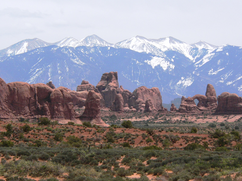
La Sal Mountains and Arches
From the reunion it was west and north to Boise. Many people find the drive from Fruita boring. The highway is fairly flat and on the Mancos Shale, ancient sea floor mud made rock, sort of. Poor soil, it is mostly sagebrush and cheat grass. South is the red rock country and the La Sal Mountains. The La Sals are weathermakers for Fruita during the August thunderstorm season.
North of the highway it’s the Book Cliffs, more shale with sandstone rims. Don’t go there after a lot of moisture. Some of the slipperiest roads anywhere are up there. Good cow country, though. Oil, gas, and oil
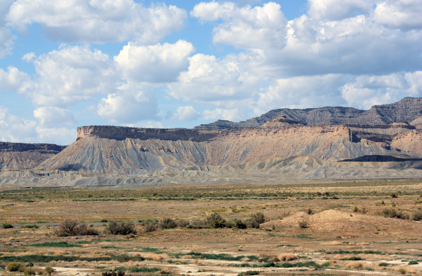
Book Cliffs
shale make the country vulnerable to destruction.
Price and Helper signal the end of the Mancos, but not without a lot of coal. The shoreline of the ancient sea was here. The highway goes up through a canyon to higher country. Cow country again, until it turns to city.
It is urban sprawl from outside Provo to where the highway branches off into Idaho. This is the Wasatch Front, Brigham’s Place. Good land, water, and a place to build. Built it is. Big City. It is much like Colorado’s Front Range. The difference, the Rocky Mountains are mostly finished rising. The Wasatch Range is not.
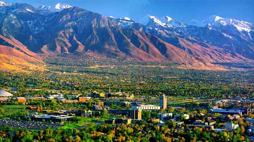
The Wasatch Front
All along the Wasatch, one can see the scarp formed by the Wasatch Fault. The mountains are on the way up, and they jerk upward along the fault. The fault is overdue to jerk upward again. When it does, Salt Lake and the other cities are in trouble. There are four major earthquake zones in the U.S. Everyone knows about the San Andreas in California; the Cascades are another, with Portland and Seattle overdue for a big quake.
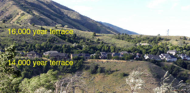
Bonneville Shoreline Terraces
Another feature of the Salt Lake Valley is the Lake Bonneville shoreline. When the ice age glaciers melted, a huge lake formed in that basin. It was so big that it overflowed into the Snake River in Idaho. The ancient shoreline terrace is visible all long the Wasatch front.
There was a wet period in the 1980’s when the Great Salt Lake grew, attempting to relive past glory. Fortunately for the city it receded. but, another problem. The Wasatch mountains are still rising. The fault at the base, the eastern edge of the city, is locked. It hasn’t shaken in a long time in human terms.
Uplifting mountains don’t rise in a steady fashion. It happens in jumps and jerks. called earthquakes. The Wahsatch has had hundreds of earthquakes in the last few million years. It is not a matter of if, but when. There are hundreds of houses built on the loose stuff that has washed out of the mountains. Shaking is amplified on that material rather than solid rock. The destruction will be staggering in impact. The prediction is the quake will be about 6.5 in magnitude.
Hi Bill, I am a member of the Salt Lake Chapter of National Charity League. We are putting together our annual program that celebrates our graduating seniors who have been volunteering with their mothers in the community for the past six years. We are looking for a photo of the Wasatch front to grace the center of our program and I saw a beautiful one on your blog. Would you allow us to use it? We do not sell or distribute the program. We product 100 copies for our members attending the event
Hi Karen.
I got that photo online and did not get permission to use it. I guess I am a bad person. Sorry, Bill