Tag Archives: Wildfire

Wildfire Revisited

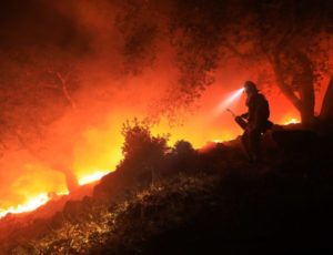
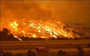
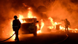
Ventura Fire

Things are hot in Southern California.  Earlier, it was hot in Santa Rosa and the Napa Valley.  When there is a high pressure system over the Great Basin and a low develops off the California Coast, the pressure gradient gives rise to hot downslope winds blowing from east to west.  The Santa Ana.  Wildfires proliferate in the mountainous chaparral country.  As the population continues to grow, the urban areas extend into the brush country.

That Great Basin high is also a fire maker for Colorado, Utah, New Mexico, and Arizona.  Here in Colorado, low pressure systems move down the Plains and the pressure gradient creates winds similar to California’s Santa Ana.  As with most natural phenomena, it is not if, but when.

It’s gonna burn, folks.

The brush country is that way because frequent wildfires prevent any significant tree growth.  When the brush burns, it tends to return in just a few years.  With trees, not so much.

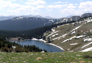
Rawah Burn. Over 100 Years, Trees Have Not Returned

I remember backpacking through a 100 year old burn in the Rawah Wilderness here in Colorado.  The trees had not returned, and the topsoil was eroded away on the hilltops.  Fires in Colorado’s chaparral country such as west of Glenwood Springs burn and in five or ten years the brush is back, ready to burn again.

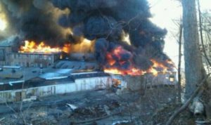
I have seen this happen in my lifetime.  The  ridges south of the Colorado River and west of Glenwood have burned at least twice.  Lightning causes some of the fires, but once a fire spread from the town dump.  The tragic 1994 fire that killed fourteen firefighters was north of the river and just west of Glenwood.  The fuel load was greater because the area had not burned for some time.
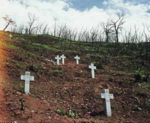


Storm King


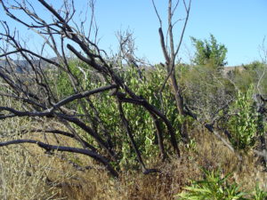
If you go back to the Storm King fire area, you will see the brush returning.  It’s not ready to burn yet, but given some time and a few wet years, it will be ready to go again.  The town of Glenwood has built up right to the brush on both sides of the river.

Brush Returning

Back to California, the towns have grown up to the brush and those wanting a view are living in the brushy areas.  The canyons are more heavily wooded and full of houses.  All the coastal mountains from San Diego north are in the chaparral zone.  All the urbanization is also in those areas.  Quick commute? Live just below the hills in a canyon.  Nice view, build your house on the ridge.

Those examples of the urban-woodland interface are not unique to Western Colorado and California.  The Colorado Front Range is another example.  Fires have burned from west of Fort Collins to south of Colorado Springs.

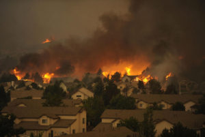
Waldo Canyon Fire


The Waldo Canyon fire burned into town on Colorado Springs’ west side and into Manitou Springs.  The Black Forest Fire was in a different climate zone with Ponderosa Pine , but with lots of brush.  That area is wetter, but is also subject to drought and wildfire, just less often.

Arizona and Utah have similar country, and fire killed 19 firefighters in mixed brush and timber just outside Prescott.  I am waiting for a big fire just west of Denver.  It’s only going to get worse.  People are moving into the brush country in increasing numbers,  if you move to Colorado or California from Chicago, you want the mountain experience.  The jobs are in the cities, and the closest mountain areas are brush country.  Four Mile Canyon outside Boulder and Ojai, California are examples of what fire does to development in the chaparral.

Young people looking for an exciting career should look into wildland firefighting.  It is a growth industry.  Oh, I haven’t even mentioned climate change.  It will increase job opportunities.
Wildfire

Some of the golden hills of California just turned black.  This time it is north around Santa Rosa and the wine country.  Usually it is the San Gabriel mountains or other Southern California areas.  The conditions leading to destructive wildfire are the same.  There are essentially two seasons; when it rains and when there is no rain.

This year there was a lot of rain in what passes for winter in all of California.  Everything greens up and grows.  It means good feed for cattle, and lots of fuel in the fall when it dries out.  You are probably familiar with the Santa Ana winds in Southern California.  The desert Great Basin east of the mountains cools off, creating an area of high pressure.  The pressure creates west-flowing winds, blowing to the coast.  As the winds hit the mountains, they rise, cool, then flow down the west side of the mountains, warming as they flow west.  Thus the Santa Ana winds, hot dry wind flowing west and drying all that foliage that grew during the rainy season.

In Northern California, the winds are called Diablo winds, after the local Diablo mountains.  The high pressure west of the coastal region originates from high pressure following storms blowing into the basin from the stormy northwest.  The high pressure again creates west flowing wind howling down the west side of the mountains.  The fires are set or lightning started, and burn across the valleys.  That means the golden hills, vineyards, and Santa Rosa suburbs.

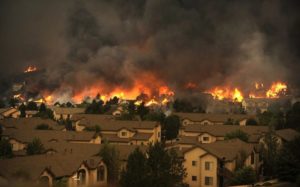
The fire triangle: fuel, heat, and oxygen.  The fuel grew, much heat comes with the wind, which also supplies plenty of oxygen.  Add an ignition point, and it burns.  The wind and fire blows down canyons, and people like to live in the canyons.  When all the space in the canyons is full, people move into the hills.  It is called the urban-wildland interface.  The entire American West is growing in population, and the new people moving in want to experience some open space.  The open space is open because it periodically burns, thus no forest, just chaparral and grassland.  And houses.  Destruction.

Is climate change partly responsible?  You decide.  California has always had destructive fire blowing in from the west, but is climate change exacerbating the natural phenomena?

Here in Colorado, we also have destructive wildland fires fanned by downslope winds.  Here the winds are from the west, hit the mountains, rise, cool, and roar down the eastern side of the mountains, fanning fires.  People are moving into the areas where the fires have always burned, and their houses burn.  The Plains east of Denver see huge grassland fires, especially after a wet spring.

Storm King Fire, Glenwood Springs CO

Western Colorado also has wind accelerated fires.  Westerly winds encounter the west side of the Rockies, rise, cool, and descend into the area around Glenwood Springs.  The country is the Colorado equivalent of California Chaparral.  The brush burns got, killing firefighters and threatening towns.  It is only a matter of time before things get hot in Glenwood, Newcastle, and Carbondale.

The West is a wonderful place, with open space, mountains, deserts, and a harsh climate.  People moving there beware, the conditions are more violent than in the well-watered East.  Oh, and don’t forger the landslides and avalanches where it is steep, along with fire.  There is lots of steep country.   There is steep country just west of all the people living along the Front Range.  The fires just might burn into town, just like Santa Rosa.

Waldo Canyon Fire, Colorado Springs

Colorado Springs has seen fire, along with Boulder.  Some day a fire may want to go downtown in a Front Range city. It is also likely a mountain town like Evergreen or Estes Park will burn.  The Mountain Pine Beetle has left a lot of standing dead trees ready to burn.

Why do I seem to be writing about fire, earthquakes, hurricanes, and other means of destruction? Maybe because I am confronting my own mortality.  I just turned 75.  I know it is surprising because I look so young.