Category Archives: Yellowstone Volcano

Plate Tectonics

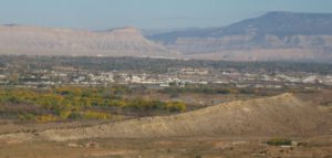
Western Colorado’s Grand Valley

As a Western Colorado Native, having lots of geology looking down on me sparked my interest in the field.  I have to know, so knowing how the Bookcliffs, Grand Mesa, and the Colorado National Monument got there stirred my curiosity.  Plate Tectonics is responsible for that stuff poking up all over the place.

Back in the Permian when I took geology at Mesa College, the orthodox explanation for mountain building was something called isostasy.  Push down in one place, and something will pop up nearby.  New Orleans and the Mississippi Delta is sinking under the weight of all that mud coming down the river.  New England is rising a little because that heavy glacial ice sheet melted.  Geologist tried to make isostasy work in places like California with little success.

The early twentieth century saw some new thinking.  Alfred Wegener proposed that continents move around on our sphere.  He was laughed at when he gave papers on the idea.  Yes, Africa and South America look like they once fit together, but how can an entire continent move?  That is a lot of mass to be sliding around.

In the nineteen sixties new thinking started to change attitudes.  Why are there identical fossils on the African and South American coasts?  The real game changer came when oceanic exploration found the mid-oceanic ridges with young basalt near the ridges and steadily getting older farther away.  The only explanation was a spreading seafloor.  Things are on the move.

After college I subscribed to Scientific American magazine.  It seemed like a new article appeared every month explaining how physical features are the result of magma (molten or hot and plastic rock) on the move.  There are seven big (North America, Asia) plates and a number of smaller ones being affected by the rock coming from that spreading seafloor.

Subduction

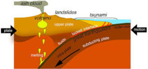
As the oceanic sea floor impacts the boundary of a continent, something has to give.  The more dense seafloor basalt tends to dive under the continent.  They can form trenches almost seven miles deep next to a subduction zone where the plate dives under the lighter rock of a continent.  The subducting rock is wet, and changes chemically forming lighter rock that often belches up as volcanos.  Earthquakes occur as the plates bump against one another, dip, or slide.

The island arcs off Asia are the current example.  Java, the Philippines, Japan, New Guinea are all volcanic islands getting ready to smash into Asia.  India already has, creating the Himalayas at the suture.  Lots of shaking there, too.

Around 1.75 billion years an island arc docked (yes, geologists use that word) on the Wyoming Craton.  The craton has some rocks as old as six billion (abbreviated as 6 ga) years old.  Many of the rocks are around 3 ga.  The oldest Colorado rocks are around 1.75 ga.  Just outside Morrison, Colorado is the Great Unconformity.  The red rocks are about 60 ma (million years).  The dark gneiss and schist just barely up Bear Creek canyon are those 1.75 ga guys.  Lots went on between those dates, but there it is all eroded away.

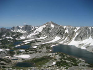
Snowy Range, formed by Colorado smashing into Wyoming

The Snowy Range in Wyoming is a result of the join-up.  The coastal ranges in California that like to shake and burn and belch fire and rock formed from the collision of the Pacific and North American plates.  As you are probably aware, L.A. is headed for Anchorage.  Don’t worry it’s going to take a while.

The Rocky Mountains are kind of a strange story.  Usually mountain building occurs at plate boundaries, like the Andes and the Cascades.  What is known as the Laramide Orogeny that created the Rockies happened about 800 miles inland.  The idea is that for some reason about 80 ma the pacific plate scooted under the lighter continental rocks before diving. The Rockies came up a bunch, the Colorado Plateau, my homeland, not so much.

The Rockies are now sitting still but the plateau is moving clockwise, pulled by the pacific plate sliding north against and under the north american plate at the continental boundary, as things should happen.  The Basin and Range province, Nevada mostly, is being pulled apart.  For some reason the Colorado Plateau wants to stay in one piece while western Utah, Arizona, and Nevada are coming apart.

All this motion is happening at about the rate your fingernails are growing.  It doesn’t seem like much, but after a few million years we are talking big moves.  Stay tuned.

My favorite book on these topics is Annals of the Former World, by John McPhee.  It is a big book composed of sections covering the territories along I-80.  Great reading.
Weird Wyoming

Along with having the entire atmosphere pass through the state in any 24 hour period, Wyoming has some other attributes beside the wind.  I like Wyoming for its diversity and the fact it doesn’t have too many people.  The diversity also extends to the geology. Prairie in the east, Devil’s Tower and the beautiful country around there to some of the most spectacular alpine country anywhere, even if the mountains are lower than ours in Colorado.  Oh, and Yellowstone, our first National Park.

Wyoming Geology

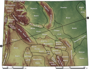
I especially like the deserts, like the Great Divide Basin, aka the Red Desert, a depression rimmed by the Continental Divide.   Yellowstone is the largest and most dangerous volcano in the country.  There is coal, iron ore, oil and gas, uranium, and trona, to name a few.  Those resources are a double edged sword, leading to a boom and bust economy.  Ranching just soldiers along,  but it is a hard way to make a living.

A good portion of the economy comes from Greens (Coloradans, known for their green license plates).  It’s the topography that draws me.  Rivers flowing north, through mountain ranges, fed by hot springs.  A range of hills known as the gas hills, where methane comes out of the ground.  Mountain ranges running north and south as God intended, but the Snowy Range runs east-west and is the boundary between the ancient island arcs known as Colorado and the much more ancient Wyoming Craton.

The Wyoming Craton has some of the oldest rocks in North America, sharing the antiquity with the Canadian Shield.  Ages vary but are around 2.6 to 2.8 billion years old.  The oldest rocks in Colorado are around 1.7 billion years old and arrived as an island arc smashing into Wyoming, much as Indonesia and the Philippines are headed to Asia.

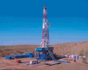
Wyoming has had a lot of activity down deep, shoving mountains up and sliding them around.  That pushing and shoving means areas where oil and gas get concentrated in the bends and corners, thus all the oil patch work there.  There is a lot of coal. The Union Pacific got its coal right near the tracks, and there is a tremendous amount of coal in the Powder River basin.  Coal is out of favor now, so Gillette is hurting, people leaving.

The reason Wyoming got famous is for two reasons, unruly Indians and the livestock business.  There was a lot of Indian fighting in the middle of the nineteenth century, what with the Oregon Trail crossing the region.  When the Indians were whipped, all that empty country became home to cattle and sheep.  The livestock people still hold most of the political power – they also have oil and gas leases, so they aren’t very environment friendly.  Lots of cowboy legends came out of the place.

My favorite things are the rivers running through mountain ranges.  The textbook example are the Wind and Bighorn rivers.  They got their names because early explorers didn’t realize they are the same stream bisected by the Hot Springs Mountains.  The Bighorn flows south through Thermopolis and its hot springs and roses into a beautiful narrow canyon.  The Wind River flows out of the canyon.  The river was there, the mountains came up, and the river (rivers?) stayed in the same place, cutting the canyon as the uplift occurred.

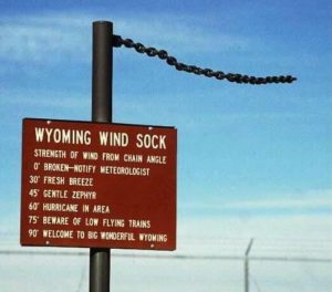
Do I need to say the Wind River is aptly named?  Years ago in Colorado Springs I met a bicyclist doing a ride across the country.  He came across Wyoming.  He looked at me and in awe said,  “The Wind”.  He rode into the wind all across the state.  Another time I was driving from Laramie to Fort Collins after dark. It was Christmas time and the ground blizzard was in full song. I saw a VW bus along the road near Tie Siding. In conditions like that, you stop.  The occupant was from Australia and said “I’ve never encountered weather like this.”  It was around zero with 50 mph wind.  The VW had quit, probably a frozen gas line, and his wife got a ride into town to get help.  Shock and awe.  I just laughed and saw he was OK.  You know about the Wyoming Wind Gauge.  It’s a length of heavy chain hanging from a post.

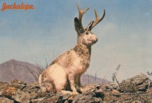
Jackalope,, Wyoming State Animal

There is usually a Jackalope colony nearby.

There are three books I recommend:

Rising From the Plains, John McPhee; Roadside Guide to Wyoming Geology; and Wyoming Geologic Highway Map

Our Little Planet

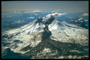
Mt. St. Helens showing a Lahar, a mud and ash flow that ran 50 miles downstream during the eruption.

Mt. St. Helens showing a Lahar, a mud and ash flow that ran 50 miles downstream during the eruption.

Stephen Hawking says we need to have to develop means to get off the planet when the Big One, whatever it is, is about to strike.  That is not terribly realistic, relocating several billion people to a place light-years away.  In other words, life on earth is toast.  Someday.In the meantime, life goes on.  It is spooky how we are fouling the planet.  We humans may create the need to get off this little ball without the means to do so.  In other words, life on earth is toast.  Sometime, maybe sooner.So, let’s deal with what we have while we can.  There are things we can do, but the means to act are part of a political process.  As long as politics is motivated by greed at the level it is currently, we are likely toast.  Maybe sooner.

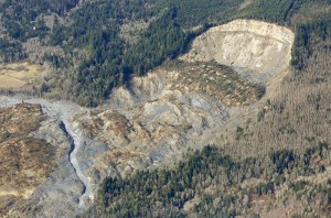
The cliff that collapsed into a massive mudslide is seen covered with felled trees in Oso, Washington March 31, 2014. Recovery teams struggling through thick mud up to their armpits and heavy downpours at the site of the devastating landslide in Washington state are facing yet another challenge - an unseen and potentially dangerous stew of toxic contaminants. REUTERS/Rick Wilking (UNITED STATES - Tags: DISASTER ENVIRONMENT) - RTR3JE4A

The cliff that collapsed into a massive mudslide is seen covered with felled trees in Oso, Washington March 31, 2014. Recovery teams struggling through thick mud up to their armpits and heavy downpours at the site of the devastating landslide in Washington state are facing yet another challenge – an unseen and potentially dangerous stew of toxic contaminants. REUTERS/Rick Wilking (UNITED STATES – Tags: DISASTER ENVIRONMENT) – RTR3JE4A

As individuals, we must do what we can, and get along with our lives.  We can help, and maybe stave off the inevitable to some degree.  We can respond to natural events.  Floods, earthquakes, tornados, landslides, hurricanes, those things we can react to and help.  We must do more than sit in the Lazy-Boy looking at the screen eating Doritos.  We can give money away, stir things up in meetings, vote, and give some time.

Well, we can do things until Yellowstone blows.  It is surprising how resilient humans are.  Ice ages, cataclysms, droughts, they may kill some and move others around, but the species has struggled on through it all.  We haven’t been around very long, however, and haven’t had to deal with any Really Big Ones in the blink of time we have been around.

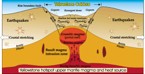
The Yellowstone Caldera

The Yellowstone Caldera

The Park Service says the Yellowstone super-volcano is pretty safe, that most eruptions are limited lava flows.  But, someday, it will be like the last big one that created a caldera almost as large as the park.  The Snake River Plain in Idaho with all those lava flows is the track of the Yellowstone hot spot as the North American Plate traveled west.  The plate moves at about the rate your fingernails grow.  As it moves, it erupts.  It just takes a while.

Hurricanes, tornadoes, floods, drought, all interest me, but I am most interested in geologic cataclysm.  One of my favorite potential geologic disasters is climate-related.  Years ago I read an article proposing that sea level rise could lead to the Gulf Stream moving over the continental shelf and invading the Arctic Ocean.  Europe would cool off with the loss of that warm water and the Arctic Ocean would thaw.  With all that open water in the north, evaporation would increase, snowfall would increase in the Arctic, precipitating a new ice age.

I haven’t seen much on that hypothesis lately.  Researchers seem to be concentrating on the rapid melting going on without Gulf Stream migrations, although the Gulf Stream does seem to be weakening.  There are just so many variables to consider.

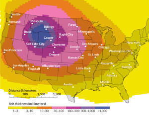
Ash From a Yellowstone Eruption

Ash From a Yellowstone Eruption

With respect to the Yellowstone super volcano exploding and killing most life in North America, there is only one variable: when.  A couple of years ago I was on a ramble in Wyoming.  Fort Laramie was my destination, but on the way I looked for the Oregon-California trail wagon ruts along the Platte outside Guernsey.  The ruts are dramatic, going up from the river bottom to some higher ground.  They are axle-deep in some tan colored rock that looks like sandstone at first glance.  It is volcanic tuff from the last time Yellowstone blew.  The layer is four or five feet deep about 200 miles from Yellowstone.  That is a lot of stuff blown into the atmosphere.  All that material along with the CO2 and SO2 would kill most everything for many hundreds of miles.

The most recent volcanic eruption in Colorado was about 4500 years ago at Dotsero.  The entire San Juan mountain range is volcanic.  Huerfano Butte near Walsenberg is a volcanic neck.  There are eroded lava flows on Trail Ridge Road in Rocky Mountain National Park.  There are lots of hot springs in Colorado.  Where is all that heat coming from?  Will the Glenwood Hot Springs Pool erupt?  Will Steamboat Springs’ boiler explode?

Landslides.  There is even one not far from Fruita on I-70.  Debeque canyon on the Colorado River is famous landslide country.  That landslide that killed three men outside Collbran last year is the same geologically.  Green Mountain in Lakewood has a landslide that destroyed several houses.  The Vail/Eagle River valley is good landslide country.  All it takes is a lot of moisture in spring. The canyons incising the front range are landslide prone.  All that rock will eventually find its way to Louisiana as mud.

The upside of all that landslide country is that it gives geologists and earthmoving contractors work.

There is a radioactive isotope of radon gas that is common in some of our Colorado rocks that houses are built on.  Basements become carcinogenic.  There is an anthropomorphic cause of radioactive basements as well.  In Grand Junction, uranium mill tailings were used as backfill around basements is some subdivisions.  More work for geologists, and a Superfund site.

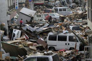
Debris is strewn over an area affected by an earthquake and tsunami in Miyako, Iwate Prefecture, March 14, 2011. REUTERS/Aly Song (JAPAN - Tags: DISASTER ENVIRONMENT)

Debris is strewn over an area affected by an earthquake and tsunami in Miyako, Iwate Prefecture, March 14, 2011. REUTERS/Aly Song (JAPAN – Tags: DISASTER ENVIRONMENT)

Earthquakes.  Again two causes, natural and human-caused.  All those earthquakes in Texas and Oklahoma caused by injecting fracking water back underground have a Colorado history.  Rocky Mountain Arsenal outside Denver was used to manufacture poison gas for military use and later poison gas for agriculture.  They pumped a lot of the toxic wastewater down wells and set off earthquakes.  They stopped that.  The oil companies are not stopping.  Yet.

Colorado is earthquake country.  Making mountains, shoving rock around to make room for more rock shakes things up.  The Flatirons outside Boulder used to be flat.  North and South Table mountains are capped with basalt from lava flows.  These processes are still going on in lots of places.

The Rio Grande Rift is a Rift Valley stretching from Southern New Mexico to north of Leadville.  The earth is pulling apart.  Look at the San Luis valley, that is a lot of pulling.  It is still going on, but slowly in human terms.  There will be earthquakes.  The biggest quake-causing fault near Denver is the Golden Fault, formed when the Rockies were uplifted.  That uplift has happened about three times.  The mountains come up, get eroded down, come up again, get eroded again.  Will it happen again?  There seems to be some weakness in the crust around here.

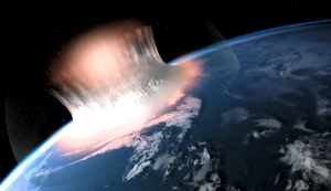
What the Meteor Looked Like Impacting off Yucutan

What the Meteor Looked Like Impacting off Yucutan

There are asteroids out there that have orbits that coincide with the earth’s orbit.  It has happened before, could again.  I saw Charlie Rose interviewing Neil DeGrasse Tyson, and he mentioned the possibility.  We have the technology to deal with the the threat, but it will take a lot of money and cooperation.  Will it happen before we need it?  Will it be too late when the danger is imminent?  Ask a Republican.  I hope you sleep well tonight.