Category Archives: Southwestern History

The Colorado Plateau Part Two


Colorado Plateau Country

Colorado Plateau Country

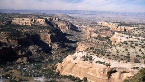
There is a lot of beautiful country on the Colorado Plateau, but there is the other side.  The term many use is the stinking desert.  My home town has an annual rainfall of about eight inches.  Before the Utes were run out and ditches were dug, the Grand Valley was a sparse desert.  The irrigation projects made much of the valley green, but north of the Highline Canal is the desert.  It is a fairly barren desert, not like the Sonoran Desert with its green saguaro cactus.

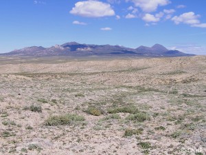
Mancos Shale Soil

Mancos Shale Soil

The soil, if you can call it that, is fairly infertile, high in salts, and high in toxic selenium.  It’s called the Mancos Shale.  The Mancos Shale, called the Pierre Shale east of the Rockies, runs from South Dakota to central Utah.  It is an ancient sea floor, Cretaceous in age, of the inland sea covering much of North America.  Shale is mud rock, laid down as the sea advanced and retreated over millions of years.

The lower part of the Bookcliffs and the valley floors are Mancos Shale.  In its natural state it is a scrub grassland, supporting small populations of deer, antelope, prairie dogs, sage grouse, cottontails, and some Bison.  When the Northern European Americans arrived, they saw grazing land.  The sheep and cattle came.  The ranchers did well for a few years, but their expectations were unrealistic for such a dry area.  Soon, most of the good grass was gone, replaced by cheat grass and sagebrush.

The area between Delta and Grand Junction is a prime example.  My father, born in 1903, lived in Grand Junction after 1918.  He told me that at that time, there were extensive stands of tall bunch grasses.  They are gone.  That desert is one of the most barren stretches I am aware of.  It is hilly, so irrigation water went to flatter areas.  It is close to towns, so lots of ranchers grazed their stock on the land.

Much of the Mancos shale country is BLM land today.  In the old days, the Land Office and the Grazing Service leased land to ranchers.  There were allocations on the number of head allowed on each segment, but there was little enforcement.  The grass mostly disappeared.  Thus, the stinking desert.

I-70 from Palisade to the west of Green River, Utah is on the Mancos.  Highway Six from where I-70 veers south almost all the way to Price is on the Mancos.  Travelers on those highways have the bare Bookcliffs and the bare desert floor to look at for over 200 miles.  Their impression was what tended to keep the canyon country to the south relatively isolated.  Locals had all that magnificent country mostly to themselves.

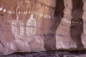
Art in Salt Creek Canyon

Art in Salt Creek Canyon

The a uranium and oil and gas booms of the 1950s built a large network of roads and opened the canyon country up for tourism.  Those flat deserts remain empty, along with the mostly shale country of the Bookcliffs and the Tavaputs Plateau to the North.

When I went to Arches in the 1950s, we drove down two tracks winding through the sand.  This year during the height of the season, cars were lined up literally for miles.  Canyonlands National Park is also crowded, people lined up.  I remember going there and often seeing no one.

From Green River to Hanksville is mostly flat, dry desert, with 70 miles from the highway turnoff to the Maze District Ranger Station in Canyonlands.  The greater part of Navajo country in southern Utah, New Mexico, and Arizona is fairly flat desert.  Monument Valley is flat desert that happens to have some rocks sticking up.  Have you ever driven from Albuquerque to Flagstaff on I-40?  Flat desert.

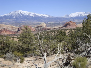
Henry Mountains

Henry Mountains

The Colorado Plateau does have some other features.  Mountains, tall, green, and wet, supplying water to the desert.  Three ranges of mountains, the La Sals near Moab, the Abajos, known to locals as the Blues, and the Henry Mountains, near to nowhere.  The La Sals are the tallest, over 12,000 feet.  The Abajos and the Henrys stretch to 11,000 feet.  They stand in contrast to the red rock country surrounding them, and provide a welcome relief.  People go there in summer to cool off and enjoy the wildlife.

Geologically, the mountains are Laccoliths, formed by a neck of molten magma rising to a weaker junction between two layers of sandstone.  At that junction the magma moves laterally, forming a mushroom shaped dome of igneous rock in the domain of sandstone.  The overlying strata usually erode away, leaving the igneous core.  The Henrys are the type location for Laccoliths, being the subjects of the earliest study, and displaying the domed shape.

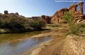
Salt Creek Canyon

Salt Creek Canyon

The three ranges are important to ranching, providing water, hay farming, and a summer range, with the stock wintering on the desert.  Salt Creek, draining north from the Blues, has a canyon with year-round water, arches, and Ancestral Puebloan ruins and rock art. The canyon also provides access to a park in the midst of the Needles District of Canyonlands.  I like that park because it was never grazed.  It provides a look at the land before cattle came, trampling or eating everything, mangling stream banks, and bringing alien species like cheat grass.  No I won’t tell you where it is.  Go look for yourself.
 

Book Review: Battles and Massacres on the Southwestern Frontier


Here is a book review I wrote for the Overland Journal, the quarterly magazine of the Oregon California Trails Association.  I am Vice President of the Colorado Cherokee Trail chapter of the organization.  The review is the reason  for a delay in getting a post up.  I had trouble with one section of the book which has poor graphics and some errors, although it is important research.  It took weeks of ranting at people about it until I was able to calm down and include a short paragraph pointing out the problems.  Maybe next time I won’t get so personally involved in someone else’s work.


BATTLES AND MASSACRES ON THE SOUTHWESTERN FRONTIER: HISTORICAL AND ARCHAEOLOGICAL PERSPECTIVES


Edited by Ronald K. Weatherington and Frances Levine

Norman:  University of Oklahoma Press, 2014

248 pp., photos, maps, illustrations, extensive references, index

Paper, 5” x 8”

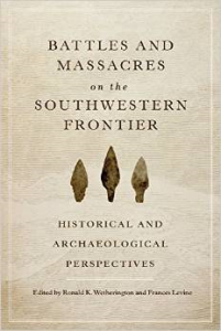
Battles and MassacresBattles and Massacres is a book that looks at several battles or massacres in the mid-nineteenth century from the perspectives of historians and archaeologists.  This is important because the historical record is usually written by one side of the conflict.  The archaeological record does not engage in cover ups, obfuscation, or have a political agenda.

The book examines four nineteenth century events in the American southwest involving Native Americans and Euro-Americans and the conflicts rising from westward expansion.  The encounters are the Battle of Cieneguilla in New Mexico, Adobe Walls in Texas, the Sand Creek Massacre in Colorado, and the Mountain Meadows Massacre in Utah.

The first three were direct conflicts involving Indians and soldiers or buffalo hunters.  Mountain Meadows was between Mormons of Southern Utah and a train of emigrants headed to California.  Some Paiutes acted with the Mormon militia.

This book is important in illustrating how modern archaeological methods can apply objective information to a historical record that can be essentially accurate, as at Adobe Walls, or what amounted to a cover-up at Cieneguilla.

Adobe Walls was a trading post in the Texas Panhandle occupied by a number of hide hunters engaging in killing as many Bison as possible for profit, while destroying the Native Americans livelihood.  A large group of Cheyenne warriors, believing that their medicine would protect them from the hide hunter’s bullets, attacked twenty-eight men and one woman.  The medicine did not work.  The big buffalo rifles were able to outrange the attacker’s weapons and many Indians were killed.  Three of the defenders were wounded.

The archaeological data showed that the majority of the Indian weapons were relatively short range rifles like the Henry and Spencer carbines, easily outranged by the big Sharps rifles of the hide hunters.  There were bullets from muzzleloaders and steel arrow points as well.

The recent archaeological investigations at Sand Creek have established the actual location of the massacre and validated the conclusion that there was a slaughter of people who were not able to effectively defend themselves, believing that they were under the protection of the U.S. Government.  Almost all of the recovered artifacts were from Army weapons.  The massacre was the result of John Chivington deciding that the Indians should all be killed.

Mountain Meadows is different, mostly Euro-Americans killing other Euro-Americans.  The essay in this book is unusual in that it comes from a Mormon Church historian and places culpability on the Southern Utah Mormon leadership for the massacre.  Given the tensions prevailing between the Utah Mormons and the U. S. Government, it was understandable there would be some conflict between the Mormons and a wagon train from Arkansas, but how it escalated into the slaughter of all the migrants over seven years old remains obscure.

Archaeological investigation at Mountain Meadows is difficult because of repeated disturbances over 150 years and the resistance of the Utah political leadership.  A study that was halted by the then Utah Governor, a descendant of one of the attackers, did provide forensic information that reinforced the conclusion that the emigrants were disarmed and slaughtered.

The studies of the battle of Cieneguilla in 1854 illustrate how an archaeological survey can refute the historical accounts dating from the time of the battle.  Of sixty troopers of the First Dragoons led into battle by Lt. John Davidson, twenty four were killed and twenty three wounded by about 100 Jicarilla Apaches.

The official report by Lt. Davidson is a story of a gallant attack by Dragoons against a superior force.  In fact, the troopers, after leaving their horses in a canyon bottom, attacked uphill and were outflanked and hunted down by the Apaches as they tried to retreat.  A Lt. Bell attempted to correct the report, but never received a hearing and was subsequently killed in action.

While the Cieneguilla study is important, there are some flaws.  The archeology is well done, the maps are not, making it difficult to visualize the entire battlefield and the movements of the combatants.  In addition, both essays explore the Battle of Cieneguilla, but fail to mention that what was Cieneguilla in 1854 is now Pilar, not far south of Taos.

The real tragedy of Cieneguilla is that the Apaches were then hunted down, starved, and sent to a reservation.

Overall, the book does an effective job of showing how history and archaeology can come together to provide a more accurate picture of events that occurred more than 150 years ago.