Category Archives: Sand Hills

Eolian Deposition

Loess Caves in China

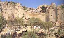
While studying a geography unit in grade school I was fascinated by the extensive deposits of loess in China.  Loess is fine wind-deposited soil.  In China, the loess covers a huge area in central China and is an important agricultural region.  The soil is fertile, easy to work, and when it erodes it can form steep cliffs.  People have carved homes into the cliffs for centuries, long enough to be included in geography books in western Colorado.  I lived in western Colorado cliff country, probably responsible for my interest in loess.

Loess is eolian soil, meaning it is wind deposited.  There is also wind deposited sand.  The Colorado National Monument, across the Colorado River from Fruita where I grew up has lots of eolian sandstone.  The cliff forming Wingate and the arch forming Entrada Sandstone are ancient sand dunes turned to stone.  My fascination for wind deposited cliffs comes naturally.

I now live east of the Rocky Mountains.  The mountains are tall and rugged, but are in the process of wearing away.  The Rockies have had several glacial periods.  Glaciers form, grind the mountains, then melt and leave their grinding as sand, silt, and gravel called glacial till. The more coarse debris often was carried in huge quantities onto the plains.  The  smaller particles, sand and silt, were blown onto the plains east of the eroding mountains.

The sand has created extensive sand hills on much of the plains in Colorado.  The sandy soil is thin and fragile, poor for farming, but fine for livestock grazing.  Interspersed among the sand hills are loess deposits now farmed extensively with water drawn from the Ogallala Aquifer in the Ogallala Sandstone, which was washed out of the mountains as the glaciers melted. The Ogallala extends from the mountains into Nebraska and south into the Texas Panhandle.
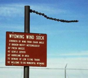
You may be aware the wind blows in Wyoming.  The entire atmosphere passes through Wyoming in any 24 hour period.  You have seen the Wyoming Wind Gauge?  It’s a logging chain hanging from a post.  I may exaggerate here, but not much.

While blowing, wind carries sand eastward out of the mountains. It also erodes the prairies in eastern Wyoming.  The sand ends up in the Western Nebraska Sand Hill country, covering over a quarter of the state.  The silt blew farther east, building loess deposits along the rivers.

In the dust bowl years in southeastern Colorado, northeastern New Mexico, southern Kansas, and the Texas and Oklahoma panhandles, the dust storms sent silt as far as Washington D.C.  Wind blown stuff is a big deal everywhere.  In North Africa, the sandy deserts are getting sandier as the silt is picked up and blows across the Atlantic Ocean, fertilizing the Amazon Basin.

In Denver, a car sitting outside for several days acquires a significant coat of wind blown dirt.  A couple of years ago, the dirt was red, meaning it originated in eastern Utah.   I notice my sidewalk is lower than the lawn by a couple of inches.  How much of it is organic accumulation and how much is eolian silt and sand?

I went for a long time thinking water is responsible for most of erosion.  It may be true, but don’t discount the wind, especially in Wyoming.
Minneapolis Road Trip

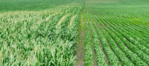
Corn and Soybeans

Corn and Soybeans

I am back from a road trip to Minneapolis on family business. I will tell the family story later, this is about the road. People say I am a bit weird. I like road trips and enjoy not listening to anything but the sound of Diesel engines as I pass the trucks. I watch, listen, and as much as possible these days, think.

This time I was in a hurry to get there, so it was I-76, I-80, and I-35 to Minneapolis. I have done I-80 for you, and I-35 is more of the same-corn and soybeans. Some of the time it is soybeans and corn. The highway through Dezz Monezz is a bit dodgy, lots of turns and traffic.

The return trip a week later was more fun. I have known various people from Mankato over the years, but had never been there. I have always liked the name. The Native Americans were screwed in southern Minnesota more than many other places, being hauled off to Fort Snelling and imprisoned. We need to keep the memory of what happened to those people, here in the land of the free.

The drive from Minneapolis (I like writing that word, much better than MPLS.) to Mankato follows the Minnesota River for much of the way. The country is hilly and wooded, with farms on every available flat spot. Beautiful. Those of us from the West are a bit snobby about the Midwest, but there is beauty most everywhere you look. Except for the monotonous corn and soybeans. That country must be spectacular in the fall.

Close to Minneapolis, the Minnesota River is navigable. I like seeing ports in the middle of https://en.wikipedia.org/wiki/Valentine,_Nebraskathe country. West of Mankato, one finds corn and soybeans. My next goal was the Nebraska Sand Hill country and the Niobrara River. I followed the River from Niobrara to Valentine. It is farm country, but that River is always right over there.

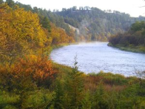
Niobrara River

Niobrara River

The River is a national treasure. Designated a Wild and Scenic River, it winds through hilly country and is bordered by woodlands. There aren’t many people in that area, another benefit. One can get a sense of what it must have been like before the European Invasion. I am sure it was better then than it is now.

Valentine has 2700 people, but is the commercial center for a wide area. It goes on my list of nice small towns. There are several River outfitters based around there for people doing canoe trips on the Niobrara. I still want to do that in the next few years before I am too decrepit for that sort of thing.


The Sand Hills

The Sand Hills

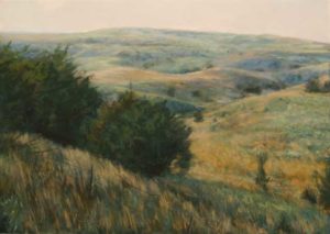
The Sand Hills. So beautiful I almost ran off the road while taking it all in. It is truly hilly there. The northern Sand Hills get quite a bit of moisture and there is water. Like western South Dakota there is a sense of space. You are in the West, not the corn and soybean Midwest. Do I seem a bit biased?

Cow country. U.S. Highway 83 from Valentine to North Platte is 115 miles of ranch country. Thedford is 58 miles south of Valentine with no towns. There is a school about halfway. There are ranches all along the way, every mile or half mile or so, and lakes. There is a national wildlife refuge there. Sandhill Cranes and a lot of other wildlife. No antelope. There should be, but there are probably too many fences.
As you drive south it dries out. In late August it is green around Valentine, but fairly brown closer to North Platte. We are talking about a huge area of northwest Nebraska, and as good cattle country as anywhere. We should be eating grass fed beef from there rather than corn fed feedlot beef from along the Platte. There would be less corn across the Midwest.

The wind blows out there. I saw five or six huge wind farms making power in Nebraska. There was one in southwest Minnesota. I saw none in South Dakota or Colorado. The sun doesn’t always shine out there, but the wind almost always blows, even at night. All that wind from Wyoming has to go somewhere. I saw a number of trucks hauling those long wind vanes, so the wind power business is growing. Wind makes more sense than solar in more northern parts of the country. Home rooftop solar is good, you can’t have too many wind turbines in town. More wind power, less coal trains rattling through Alliance.

Back in Colorado, along the South Platte, there is lots of history. Gold rush wagon trains, Indian wars, farming and cattle. One of the small towns is Iliff, named for an early rancher who got rich raising beef for the miners. He was another of those Methodists who had a big role in early Colorado. Evans, Chivington. Iliff founded the Methodist seminary at Denver University.

I have to get out to Julesburg and poke around the history there then go up to Scotts Bluff on the North Platte, with a stop at Fort Laramie on the way home. Another road trip.