Tag Archives: Wyoming

Eolian Deposition

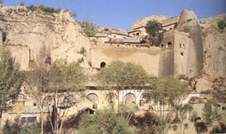
Loess Caves in China

While studying a geography unit in grade school I was fascinated by the extensive deposits of loess in China.  Loess is fine wind-deposited soil.  In China, the loess covers a huge area in central China and is an important agricultural region.  The soil is fertile, easy to work, and when it erodes it can form steep cliffs.  People have carved homes into the cliffs for centuries, long enough to be included in geography books in western Colorado.  I lived in western Colorado cliff country, probably responsible for my interest in loess.

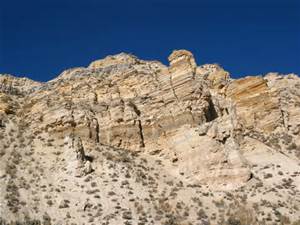
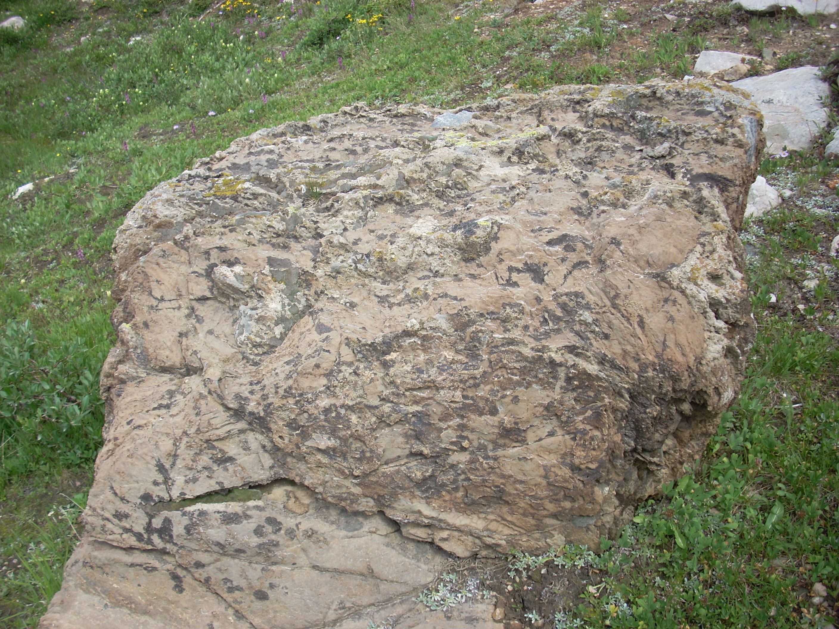
Loess is eolian soil, meaning it is wind deposited.  There is also wind deposited sand.  The Colorado National Monument, across the Colorado River from Fruita where I grew up has lots of eolian sandstone.  The cliff forming Wingate and the arch forming Entrada Sandstone are ancient sand dunes turned to stone.  My fascination for wind deposited cliffs comes naturally.

I now live east of the Rocky Mountains.  The mountains are tall and rugged, but are in the process of wearing away.  The Rockies have had several glacial periods.  Glaciers form, grind the mountains, then melt and leave their grinding as sand, silt, and gravel called glacial till. The more coarse debris often was carried in huge quantities onto the plains.  The  smaller particles, sand and silt, were blown onto the plains east of the eroding mountains.

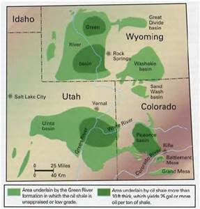
The sand has created extensive sand hills on much of the plains in Colorado.  The sandy soil is thin and fragile, poor for farming, but fine for livestock grazing.  Interspersed among the sand hills are loess deposits now farmed extensively with water drawn from the Ogallala Aquifer in the Ogallala Sandstone, which was washed out of the mountains as the glaciers melted. The Ogallala extends from the mountains into Nebraska and south into the Texas Panhandle.

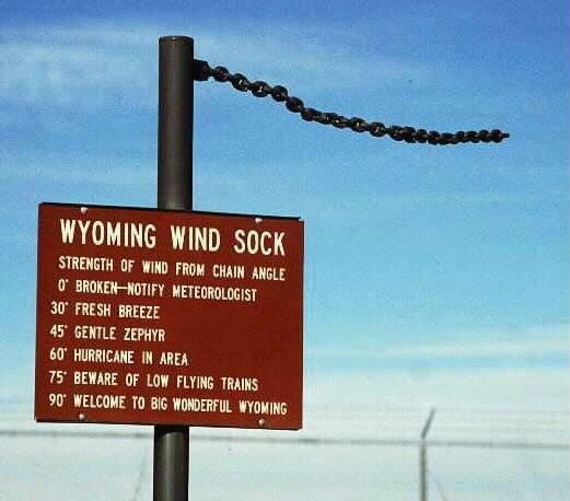
You may be aware the wind blows in Wyoming.  The entire atmosphere passes through Wyoming in any 24 hour period.  You have seen the Wyoming Wind Gauge?  It’s a logging chain hanging from a post.  I may exaggerate here, but not much.

While blowing, wind carries sand eastward out of the mountains. It also erodes the prairies in eastern Wyoming.  The sand ends up in the Western Nebraska Sand Hill country, covering over a quarter of the state.  The silt blew farther east, building loess deposits along the rivers.

In the dust bowl years in southeastern Colorado, northeastern New Mexico, southern Kansas, and the Texas and Oklahoma panhandles, the dust storms sent silt as far as Washington D.C.  Wind blown stuff is a big deal everywhere.  In North Africa, the sandy deserts are getting sandier as the silt is picked up and blows across the Atlantic Ocean, fertilizing the Amazon Basin.

In Denver, a car sitting outside for several days acquires a significant coat of wind blown dirt.  A couple of years ago, the dirt was red, meaning it originated in eastern Utah.   I notice my sidewalk is lower than the lawn by a couple of inches.  How much of it is organic accumulation and how much is eolian silt and sand?

I went for a long time thinking water is responsible for most of erosion.  It may be true, but don’t discount the wind, especially in Wyoming.

Weird Wyoming

Along with having the entire atmosphere pass through the state in any 24 hour period, Wyoming has some other attributes beside the wind.  I like Wyoming for its diversity and the fact it doesn’t have too many people.  The diversity also extends to the geology. Prairie in the east, Devil’s Tower and the beautiful country around there to some of the most spectacular alpine country anywhere, even if the mountains are lower than ours in Colorado.  Oh, and Yellowstone, our first National Park.

Wyoming Geology

I especially like the deserts, like the Great Divide Basin, aka the Red Desert, a depression rimmed by the Continental Divide.   Yellowstone is the largest and most dangerous volcano in the country.  There is coal, iron ore, oil and gas, uranium, and trona, to name a few.  Those resources are a double edged sword, leading to a boom and bust economy.  Ranching just soldiers along,  but it is a hard way to make a living.

A good portion of the economy comes from Greens (Coloradans, known for their green license plates).  It’s the topography that draws me.  Rivers flowing north, through mountain ranges, fed by hot springs.  A range of hills known as the gas hills, where methane comes out of the ground.  Mountain ranges running north and south as God intended, but the Snowy Range runs east-west and is the boundary between the ancient island arcs known as Colorado and the much more ancient Wyoming Craton.

The Wyoming Craton has some of the oldest rocks in North America, sharing the antiquity with the Canadian Shield.  Ages vary but are around 2.6 to 2.8 billion years old.  The oldest rocks in Colorado are around 1.7 billion years old and arrived as an island arc smashing into Wyoming, much as Indonesia and the Philippines are headed to Asia.

Wyoming has had a lot of activity down deep, shoving mountains up and sliding them around.  That pushing and shoving means areas where oil and gas get concentrated in the bends and corners, thus all the oil patch work there.  There is a lot of coal. The Union Pacific got its coal right near the tracks, and there is a tremendous amount of coal in the Powder River basin.  Coal is out of favor now, so Gillette is hurting, people leaving.

The reason Wyoming got famous is for two reasons, unruly Indians and the livestock business.  There was a lot of Indian fighting in the middle of the nineteenth century, what with the Oregon Trail crossing the region.  When the Indians were whipped, all that empty country became home to cattle and sheep.  The livestock people still hold most of the political power – they also have oil and gas leases, so they aren’t very environment friendly.  Lots of cowboy legends came out of the place.

My favorite things are the rivers running through mountain ranges.  The textbook example are the Wind and Bighorn rivers.  They got their names because early explorers didn’t realize they are the same stream bisected by the Hot Springs Mountains.  The Bighorn flows south through Thermopolis and its hot springs and roses into a beautiful narrow canyon.  The Wind River flows out of the canyon.  The river was there, the mountains came up, and the river (rivers?) stayed in the same place, cutting the canyon as the uplift occurred.

Do I need to say the Wind River is aptly named?  Years ago in Colorado Springs I met a bicyclist doing a ride across the country.  He came across Wyoming.  He looked at me and in awe said,  “The Wind”.  He rode into the wind all across the state.  Another time I was driving from Laramie to Fort Collins after dark. It was Christmas time and the ground blizzard was in full song. I saw a VW bus along the road near Tie Siding. In conditions like that, you stop.  The occupant was from Australia and said “I’ve never encountered weather like this.”  It was around zero with 50 mph wind.  The VW had quit, probably a frozen gas line, and his wife got a ride into town to get help.  Shock and awe.  I just laughed and saw he was OK.  You know about the Wyoming Wind Gauge.  It’s a length of heavy chain hanging from a post.

Jackalope,, Wyoming State Animal

There is usually a Jackalope colony nearby.

There are three books I recommend:

Rising From the Plains, John McPhee; Roadside Guide to Wyoming Geology; and Wyoming Geologic Highway Map

rat in cage two bottles

The World Famous Green River Formation, for oil shale, not beauty

The World Famous Green River Formation, for oil shale, not beauty

About fifty million years ago the Grand Canyon and the Colorado River did not exist.  The area was surrounded by the Wind River Mountains, the Uintah Mountains, the San Juans, the Uncompahgre Plateau, and the newly formed Rocky Mountains.  This huge area had no outlet to the sea.  The climate was similar to our current Gulf Coast, warm and moist.  During the six million years we are exploring, things changed.  Lakes formed and receded, land rose and subsided, and through all this the surrounding highlands were sending their sediment into the lakes.   

The Green River Formation is the result of all the sedimentation.  It is up to ten kilometers in depth, thinner at the margins.  At first the lakes were fresh water, but later became saline, leaving large deposits of carbonate rocks.  The trona deposits at Green River, Wyoming are some of the richest in the world.  The margins are sandstone and conglomerate interlaced with the fine silt that filled most of the basin.  The formation is rich in the fossils of the abundant life in the lakes.  They are world famous for their variety and abundance.   

There was an anoxic layer at the bottom that preserved the organisms settling there.  The lakes were abundant in blue-green algae.  The remains of the algae are the source of the oil shale deposits the region is known for.  The oil shale is there in millions of barrels, but it is expensive to extract the petroleum from the rock.  It may never be commercially viable, but the formation has been extensively studied as a result.  

Green River Formation Map

Green River Formation Map

Standing in my home town of Fruita looking north, the white cliffs behind the Book Cliffs are the Green River Formation.  The Roan Plateau is huge, but does not attract visitors like the red rock country to the south.  A huge exposure is the highlands west of I-70 from Rifle to DeBeque Canyon. 

My interest is from visiting ranchers and hunting in the Douglas Pass area in my youth.  Most of our visits were to ranches in the Green River Formation.  The elevations varied greatly.  The ranches were along West Salt Creek, but there were back country roads that went from sagebrush desert to piñon-juniper to oak brush shaly hillsides with sandstone rims to high country timber with world class mud.  In fact, the mud is world class everywhere in the region. 

Back before four wheel drive became common, there was a pile of rocks at the bottom of every big hill.  Load them in the back of your pickup, go where you planned, and unload them on the way home.  There is a network of canyons with side canyons branching off.  All of it is fine deer habitat.  My favorite places were at the head of a canyon with the wind in my face and a view of the LaSal Mountains and the Uncompahgre Plateau in the distance.  Flat, wooded country gives me the creeps. 

Access to a lot of the country is difficult.  Most of the land is BLM land, but the early ranchers homesteaded the choice land that had water.  The private land meant locked gates.  We knew some of the ranchers, family friends.  Hunting season was a big deal.  There were maybe a dozen or more people, hunting during the day and drinking and playing poker at night.  The big ranch house had a big kitchen with a wood burning stove along with the stove in the big main room.  There was a light plant in the shed next to the house.  It looked like no generator you see these days.  There were also lots of Coleman lanterns when the light plant failed.  Good times and lots of venison.  The unheated bunkhouse was upstairs. 

Douglas pass was up the main road, gravel in those days.  It isn’t that high by Colorado standards, but made up for it with the switchbacks up the head of the canyon to the summit up through that shale.  When the shale is wet, it moves.  The road trapped the runoff, wetting the soft shale, and most every spring one or more places slid.  The mountainside now is braided with old road cuts.  It wasn’t much of a main road in the 1950’s, but now there is so much oil and gas development that the road is a paved state highway that the highway department spends money on. 

The road crosses the desert above the Highline irrigation canal before it goes into the canyon.  It is on the Mancos shale, responsible for all that flat desert in Colorado and Utah that turns to grease when it is wet.  There was one hill the road went over then descended into the wash on the north side.  That meant the road was on a north facing slope for a distance.  That hill was named Coyote, because it could bite and gnaw on you if it was wet.  A bit farther north was a ten or twelve foot high rock on the side of the road, all by itself.  

The county employee maintaining the road in those days had his grader blade scrape on that rock every time he bladed the road.  It would leave a bump, so he would have to drag dirt over to level things out.  One day he got fed up and dug that rock up and moved it off the road.  It was probably a two day project, but he never had to fight that damn rock again. 

After I could drive, I ran around that desert quite a bit.  I learned how to drive a two wheel drive pickup in that greasy stuff from my father.  He was the telephone man in Fruita, responsible for maintaining the toll line as far as Cisco, Utah.  That meant navigating two ruts through the cheat grass and sagebrush.  He could put a two wheel drive pickup into places that were a challenge for a Jeep.  Rocks in the back, chains if needed, put it in second gear and putt along.  He seldom used the granny gear or used the gas pedal.  Those old Chevy sixes would just lug their way along.   

I am as guilty as any back country explorer for spending most of my time in the Rocky Mountains or the Utah red rock country, but the Mancos Shale and the Green River formation are calling me.  I just need to see if my tire chains are in good shape.  I think I will go over Douglas Pass, loop around and look the Piceance Basin over. From Rifle I will go down to Plateau Creek (my father and grandfather said platoo crick) and up to Collbran to look at the big slide.

Time

Time

Time

Time is relative.  It is all a matter of perspective.  It is said that realized beings like Jesus or the Buddha lived entirely in the moment, which connects them with the timelessness of being.  For mortals such as I, it is sometimes difficult to have a perspective greater than the next few hours.  Carol and I do a weekly plan, setting our schedule for that span of time.  For people in the corporate world, time usually means the bottom line for the quarter.  Children see summer vacation as lasting a long time; for us old people, it’s over in a flash. 

I seem to have several time perspectives.  In my spiritual life, I attempt to be in the moment and in the eternal.  In meditation, however, I find myself planning the next day or reviewing childhood events, not in some exalted state.  My everyday life tends to be day by day, checking the weekly plan if I remember to.  Often I can’t remember which evening I am supposed to cook. 

I have developed something of a longer perspective on life as I age.  I am shocked to realize that a lot of people were born in this century, which for me is a relatively short time.  Y2K wasn’t that long ago. I can remember Senator Joe McCarthy and the Army-McCarthy hearings when the country was experiencing  a right wing resurgence a lot like now.  That time ended, as will this one, probably in November.  I was in the Army when Kennedy was shot.  Obama is in year eight of his presidency; we have watched his daughters grow up.  As teenagers, I wonder if they think their dad is hopelessly clueless, even if he is The Man. 

Newspaper Rock, Utah

Newspaper Rock, Utah

My history professors talked about developing a historical perspective, to take a long view about human events.  To some degree I succeeded.  I can connect the pagan deities of Mesopotamia with elements of Islam, Judaism, and Christianity.  Four thousand year old Greek myths influence our current thinking.  Because of the American Civil War, I dislike grits, sweet ice tea, deep fried fish,  y’all, and that strange flag.  Most southerners are wonderful people, but I am not one of them.  But, I feel a connection with the people who illustrated their world on the sandstone canyon walls of Western Colorado and Utah. Parents with children born in 2009

2009So, where are we?  From “Do I have to go to the bathroom?”, to what’s to cook tonight, to the doctor’s appointment Thursday.  From there, it’s my lifetime and all that has gone on, even to those kids born in 2009, when my pickup was built (with a faulty airbag).from there it is the span of human history as recorded by symbols such as writing, the digital cloud, or rock paintings.  Then I  go to archeology and the origins of humankind. 

Next is yours and my favorite subject, geology and the universe.  Time changes, from hours to days to weeks, years, lifetimes, and all of human history, all mere blinks in the span of geologic time.  Four billion years ago our planet was a ball of very hot rock.  2.7 billion years ago what is now Denver was part of an island arc similar to Indonesia headed for a collision with Wyoming.  Lots of things crash in Wyoming. 

65 million years ago this place was a sea bottom, with shale accumulating that runs from South Dakota to central Utah.  Denver has gone from a hunk of hot rock to an island, a sea floor, a place being buried in the stuff washing out of the Rockies as the glaciers melted, to a place with a lot of people and their accumulated toxic waste and a lot of used plastic.   

The planet and the universe will go on, with humankind gone, mostly as a result of their own folly.  What does it all mean?  Maybe what is important is the time I took this morning to watch a big hawk fly over the DU campus looking for a little critter to eat.


Freezing on Deadman’s Hill

Deadman's Hill Lookout Tower

Deadman’s Hill Lookout Tower

I did a ramble to Deadman’s Hill and some other places. I did survive, but it was not easy.

Deadman’s Hill is west of Redfeather Lakes on a road that ends on the Laramie River road.  This is one of the more remote mountain areas east of the Continental Divide in Colorado.  Redfeather is a resort community northwest of Fort Collins and north of Rustic, in Poudre Canyon.  There are lakes, a store and post office, a restaurant, and many cabins.  There is a year-round population of about 250 people.  It is a bit funky, and nothing like the ski resorts with their upscale condos.

I went to Colorado State in Ft. Collins, lived there for several years, and never got to the area.  I have had Deadman’s Hill on my list, and tried to go over the road last spring.  Alas, the road is closed from December to June.  I was too early, but not too early to see a bear feeding in a meadow just before the closed gate.

I went back last week, the road was open and well graded.  It climbs through a Lodgepole Pine forest to a spur leading up to a fire lookout tower that has a view of most everything from Rocky Mountain National Park to Wyoming and from the plains to the Rawah Wilderness in the Medicine Bow mountains.

From the lookout tower I went down the hill a ways to a long meadow looking right at the Rawahs.  A little creek ran through the meadow and a pair of bull moose would drift out of the timber, feed for a while, and move back into the trees.

Meadow With the Rawah Mountains

Meadow With the Rawah Mountains

I got the tent up just in time for the first rainstorm, and had another storm a couple of hours later.  A pleasant and lovely late afternoon, with the solitude I always seek in the back country.

If it is not raining steadily, I set up my cot outside, with the sleeping bag inside a canvas bedroll along with a wool blanket.  I slept for a short while, got up to pee, got cold and stayed that way for the rest of the night.  I reached outside the bedroll and felt a layer of ice.  It seemed like my feet were as cold as those snowfields on the flanks of the Rawahs, and the rest of me had just come out of the water draining the snowfields.

I tried a few things that helped my body a little, but my feet got colder every time I left the sleeping bag.  Oh, and the sleeping bag zipper jammed.  No sleep, much misery.  At about 4:30 AM I climbed into my pickup and ran the heater to warm up.  Everything in the cab of that truck is lumpy or pokes you if you are trying to sleep.

At 5:30 I threw everything into the bed of the truck and went down the hill to the Laramie River road.  From there I went north to Woods Landing Wyoming, hoping to find coffee and food.  Closed.  On to Mountain Home, Wyoming, nothing there.  I went west to the road from North Park Colorado into Wyoming and south to Walden.

I found coffee, heat, food, and a semblance of civilization.  There were four old guys, retired ranchers from the look of them, sunning themselves on the patio in the 45 degree morning.  I saw some bicycles parked nearby and asked them if the bikes were theirs.  One shook his head, taking me literally at first.  None of them had been on a bicycle in at least 60 years.  You don’t ride bicycles if your headgear is a cowboy hat and your shirts have snaps, not buttons.

The bicycles belonged to some city folk having breakfast and fixing a flat tire.  They were in their 60’s.  Hardy people there, in Jackson County.

From Walden I went back north along the North Platte River into Wyoming.  The Platte and Laramie River valleys are what I think of as mountain ranch country.  Irrigated hayfields and pastures flanked by sagebrush hills rising into the timber.  Everyone waves at you.

Snowy Range

Snowy Range

I then went east over the Medicine Bow Mountains, capped by the Snowy Range.  This is one of my favorite drives.  The mountains are snowy white, jagged, and have lovely lakes at their base.  The white rock is 4 billion year old quartzite, older than anything in Colorado.  Just off the highway on the way to a campground are some stromatolites, or petrified algae, some of the oldest evidence of life on earth.Deadmans Hill 2014 012

I had lunch in Laramie and decided to return to Redfeather and get a cabin for some sleep.  There were no cabins available, so I went to Poudre Canyon, where a cabin was too expensive.  By that time I was so tired I just went home.  A tired, cold trip in some fine country.