Boise Road Trip Part Two
In the first installment I got us as far as the Wasatch Front, and warned of the future apocalypse-earthquake waiting to happen there. I was on the way to Boise, and needed gas. I took an exit and pumped gas, moved the Tacoma to a parking spot, and went inside.

Pried Open Sliding Window
When I came out I saw my keys on the seat. Oops. No spare key. I have done this before, and it usually means breaking a window. The Tacoma has a sliding rear window, useful for ventilation in good weather. I borrowed a screwdriver from the guys parked next to me. I figured that was the cheapest window to replace if I had to break it.
The window has a plastic latch and I pried between the panes there. The glass bent and the latch popped open. I have tried those magnetic key holders and they always disappear. I’ll figure out a stash spot sometime.
On the road again, I drove through some arid hilly country-cow country, in the wind. I have always thought that Wyoming is the wind capital, but the wind has to come from somewhere, I guess it is northern Utah and Idaho.
Driving on north, near the Snake River it is irrigated farmland, reminding me of home. I was getting tired and stayed in Twin Falls. It’s not that far to Boise, but when I am tired I lose concentration, not good at 70 mph.
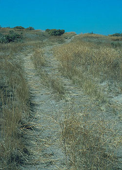
Oregon Trail Ruts
The Oregon-California Trail parallels the Snake in that region, so I went rut hunting. The Snake runs through a gorge in the Snake River Plain, so the trail left the river if there were alternate water sources. Those hills Idaho people call mountains also run parallel to the Snake a few miles north, and the trail ran there away from the river. Water was available from springs and creeks at the base of the hills. The water is gone now, victim of all the groundwater pumping by farmers.
The ruts are there, as well as the ruins of an attempt at a resort in the early part of the 20th century. I like following the trail, thinking about what it was like for the emigrants, traveling 8 to 10 miles per day, hoping for a better life at trail’s end. Many found the better life, many did not, and many died on the way.
On to Boise, seeing people I care about, and searching for Basque food. Headed home it was back to the Wasatch, then U.S. 40 east. I had never been west of Vernal, so it was new country for me. The highway rises through the Wasatch to Heber City, a nice town that reminded me of our Eagle River valley, with all the businesses supporting the ski resorts. The Wasatch Mountains are rhe easternmost range of the Basin and Range Province. The Basin and Range is being stretched as the Pacific Plate scrapes northward along the North American plate.

Uintah Mountains From US40
Leaving the Wasatch Mountains, we are back on the Colorado Plateau, with its northern boundary, the Uintah Mountains. The Uintahs are unique among North American mountain ranges, as they run east-west. They were uplifted at the same time as the Rockies, but I can’t find a good explanation of why they run east-west. There they are, and I drove east with mountains on the left and desert on the right. Come to think of it, the Book Cliffs and the Tavaputs Plateau also run east-west, but they aren’t called mountains because they are only 8000 feet high. The Uintahs have two thirteeners.
Highway 40 runs between the Uintahs and the Tavaputs. The Uintahs are important to the Salt Lake area, providing water for the growing population.They are also pristine, mostly roadless. The glaciers are gone, but they left dramatic peaks and broad mountain valleys. The core is the High Uintahs Wilderness,the rest Forest Service land providing summer range for sheep and cattle.
Next, Vernal. It reminds me of Cortez, Colorado and not in a good way. It is, however, a good jumping off spot for a lot of interesting country.
Green River Campground, Dinosaur National Monument
The eastern end of the Uintahs have Dinosaur National Monument, with its fossils and the amazing canyon of the Green River. I was camping down on the river one time a few years ago. My neighbors in the campground had some dogs they were letting run loose. I warned them about the skunk I had seen. Early next morning they learned about skunks and dogs and I got to hear some morning howls. I am glad I wasn’t in their car on the way out.
Maybell, Colorado is next, a ranching town isolated enough that the natives retain the western drawl, a dying accent. On to Craig with its coal controversy, then Steamboat on the Yampa. Pretty country. Then, drive over Rabbit Ears and Berthoud Passes, down to I-70 and a traffic jam. That meant I was close to home.
Bill, you can ask Spider, a rambunctious mixed breed collie and german sheppard who was originally hers but who bonded with me. He chased skunks every chance he got, who were attracted to Dad’s beehives.
That should be Judi about Spider.