Arkose, Sand, and Loess
Geologists like to give common things fancy names. Aeolian Deposition means wind-blown stuff from the mountains on the land. Here in Eastern Colorado the South Platte and the Arkansas Rivers are in the process of hauling everything to the Mississippi Delta. This is kind of a slow process, but a lot of stuff is already there. Lots more is on the way.
The material coming off the mountains is in three general categories: gravel, sand and dirt. The stuff gets deposited, may get buried long enough to form rock (Castle Rock), but most of it sits around for a while, maybe millions of years, before it is washed into the streams and heads east.
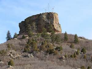
Castle Rock
Along the base of the mountains are two kinds of deposits. As the Rockies were rising, they eroded almost as fast. Out mountains are mostly the roots of what was once there. During wet periods, like when glaciers were melting, the chunks coming down were pretty angular. The geologists call the deposits arkosic. The Castle Rock Conglomerate is a good example. At other times the erosion was so rapid that a mixture of angular rock and rounded river gravel were deposited together. Rocky Flats between Golden and Boulder is an example.
There are huge gravel deposits at the mouths of the many canyons emptying onto the flatter land where all the people live today. Boulder didn’t get its name by accident. I briefly worked for the telephone company in Boulder. I was on a crew burying telephone cable in new subdivisions. I ran a backhoe and a cable plow, a small bulldozer with a ripping tooth in back digging down about thirty inches and paying telephone cable out the back of the tooth (or plow). In some places, we had to bring in a big D8 Caterpillar dozer with the power to rip through all the hard packed gravel so my little John Deere 450 dozer could do its job. It’s sort of a Mini Cooper versus a Hummer.
All those lakes you see near all the streams exiting the mountains are old gravel pits converted into water storage reservoirs. You can find gravel in the South Platte River bottom in Nebraska that came out of the Rockies. As the gravel is carried along, it erodes from angular pieces to progressively more rounded rocks, eventually becoming sand, clay, or just plain dirt.
The flat country at the base of the Rockies is a patchwork of older rocks exposed by erosion, gravels and arkose near the mountains, then lots of sand, then dirt farther out. A geologic map shows the patchwork. Nature is relentless in its processes, but they are not uniform.
Denver’s Sand Creek
Eastern Colorado has several Sand Creeks, carrying the sand that blew out onto the flats to the South Platte or the Arkansas. You can identify the sand deposits in Eastern Colorado because they are cow country, not suitable for farming. My favorite Sand Creek runs from northern Aurora through some of the old Stapleton Airport property and on west to the Platte. The Bluff Lake Nature Center can give you a good look at the sand and the loess. Bluff lake itself is down along Sand Creek where you can play in the sand. The trail leading down to the creek and lake drops down the bluff from the parking lot. The bluff is loess.
Bluff at Bluff Lake Nature Center. Loess
Under most of the eastern plains is the Pierre Shale or the Ogalla Formation. The shale can be farmed, and the Ogalla holds all that rapidly diminishing irrigation water. The surface is mostly stuff the wind blew in. The dirt the wind carries is called loess, a German word. The soil is fine, and in some places can be hundreds of feet thick. That dust on your car after it sits out in Denver? It will either be Mississippi mud or loess. Well, even the loess will be mud someday, it is just being delayed for a while.